METAR & TAF 98D
Current METAR
Observed 13:15Z
K98D 271315Z AUTO 04008KT 6SM HZ CLR 23/15 A2989 RMK AO2
- Wind
- 040° @ 8 kt
- Visibility
- 6 SM
- Temp / Dew
- 23°C / 15°C
- Altimeter
- 29.89 inHg
- Clouds
- CLR
- Density alt
- 3,334 ft
- Ceiling
- Unlimited
- Rules
- VFR
Airport info & contacts
Manager on record, flight service, ARTCC, attendance schedule and pattern altitude — published by the FAA and refreshed every 28 days.
Location
- From city
- 2 NM W
- VFR sectional
- TWIN CITIES
- ARTCC
- ZMP · MINNEAPOLIS
- NOTAM facility
- HON (NOTAM-D)
Airport manager
- Name
- TERRY BARBER
- Phone
- 605-258-2743
- Address
- PO BOX 131, ONIDA SD 57564
Flight service · Hours
- FSS HON
- HURON1-800-WX-BRIEF
- Attendance
- Unattended
Frequencies
Tap any row to copy the frequency to your clipboard.
Runways & pattern
Full pagePattern entry · RWY 08
LEFT TRAFFIC| Runway | Heading (°M) | Length | Surface | Traffic |
|---|---|---|---|---|
| 13/31 | 133° / 313° | 3,800 ft | ASPH | Standard L |
| 08/26Favored | 85° / 265° | 2,160 ft | TURF | Standard L |
Runway end performance
| End | TORA | TODA | ASDA | LDA | VGSI | Approach lights | Obstruction |
|---|---|---|---|---|---|---|---|
| 13 | — | — | — | — | PAPI 2-box left(3°) | — | — |
| 31 | — | — | — | — | PAPI 2-box left(3°) | — | — |
Declared distances in feet. TORA = takeoff run available, TODA = takeoff distance, ASDA = accelerate-stop, LDA = landing distance.
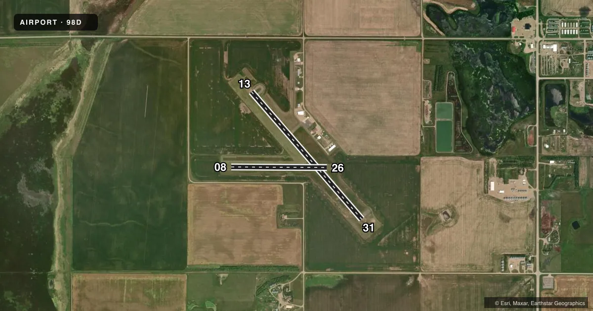
Airport sketch
Runways drawn to scale from FAA survey coordinates, rendered over satellite imagery. Not for navigation.
Approaches & charts
Services on the field
Fuel grades, oxygen, maintenance, ramp storage and lighting — as declared to the FAA by the airport operator.
Fuel & services
- Fuel
- 100LLA
- Oxygen (bottled)
- Not available
- Oxygen (bulk)
- Not available
- Airframe repair
- Minor
- Power plant repair
- Minor
- Other services
- AGRI
Ramp & ground
- Transient storage
- Tie-down
- Hangar
- Landing fee
- No fee published
- Customs
- Not available
- Lighting schedule
- SEE RMK
- Beacon schedule
- SS-SR
- Beacon
- White / Green (civil land)(WG)
- Wind indicator
- Lighted
- Segmented circle
- No
Fuel & FBOs
Cheapest 100LL and Jet A on the field and nearby. Always confirm with the FBO before taxi.
Airport notes
Surface conditions, obstructions, local procedures, lighting outages and other notes published with each FAA cycle.
General notes
- 150 FT WATER TWR 1.4 MILE SE OF RWY 31.
- ULTRA-LIGHT ACT ARND ARPT.
- WILDLIFE ON AND INVOF ARPT.
- FOR CD CTC MINNEAPOLIS ARTCC AT 651-463-5588.
Lighting notes
- ACTVT MIRL RWY 13/31 & PAPI RWY 13 & 31 - CTAF.
- ULTRALIGHTS ON AND INVOF ARPT.
Runway surface & condition
- 08/26RWY 08/26 CLSD WINTER MONTHS DUE TO LACK OF SNOW REMOVAL.
Approach & departure obstructions
- 08RWY MKD WITH WHITE & BLACK CONES.
- 26RWY MKD WITH WHITE & BLACK CONES.
Other notes
- EXISTED PRIOR TO 1959.
VFR map & nearby airports
VFR sectional. Tap any ICAO chip to open that airport.
Key facts · 98D
Answer card- ICAO
- 98D
- Name
- ONIDA MUNI
- Location
- ONIDA, SOUTH DAKOTA
- Elevation
- 1,884.8 ft MSL
- Traffic pattern altitude
- 2,884.8 ft MSL (1,000 AGL)
- Control tower
- Non-towered (use CTAF)
- Total runways
- 2
- Longest runway
- 13/31 · 3,800 ft
- Published ILS approaches
- 0
- Published frequencies
- 1
- Magnetic variation
- 6°
- Current flight rules
- VFR
- Current wind
- 040° at 8 kt
- Favored runway now
- RWY 08
Onida Muni is in Onida, South Dakota. The field elevation is 1,884.8 ft MSL. It has two runways. The longest is 3,800 ft on runway 13/31. Runway 13/31 is asphalt. Runway 08/26 is turf and 2,160 ft long. Runway 08/26 is closed during winter months because snow removal is not provided. This is an untowered field. CTAF is 122.9.
No ILS approaches are published here. Pattern altitude is not published in the facts, so use the standard 1,000 ft AGL for light piston operations unless the current FAA Chart Supplement says otherwise. The on-field FBO is Onida Municipal Airport. It carries 100LL and Jet A Prist. Call (605) 258-2743 for current service details before you go.
A few operational items matter here. Runway 13/31 has medium intensity lights. The PAPIs on 13 and 31 are activated by CTAF. Runway 08 and runway 26 are marked with white and black cones. There is a 150 ft water tower about 1.4 miles southeast of runway 31. Ultralight activity and wildlife are both reported in and around the airport. For clearance delivery, contact Minneapolis ARTCC at 651-463-5588. If you are planning a night or winter arrival, verify current conditions with the airport operator or the FBO directly by phone.