METAR & TAF 3FU
3FU does not publish a METAR.
Showing the nearest reporting station: KABR (ABERDEEN RGNL) · 38.4 NM away. Conditions at 3FU may differ.
METAR · KABR
Observed 09:53Z
KABR 270953Z AUTO 01006KT 8SM CLR 22/16 A2979 RMK AO2 SLP078 T02170161 $
- Wind
- 010° @ 6 kt
- Visibility
- 8 SM
- Temp / Dew
- 22°C / 16°C
- Altimeter
- 29.79 inHg
- Clouds
- CLR
- Density alt
- 2,949 ft
- Ceiling
- Unlimited
- Rules
- VFR
Airport info & contacts
Manager on record, flight service, ARTCC, attendance schedule and pattern altitude — published by the FAA and refreshed every 28 days.
Location
- From city
- 1 NM E
- VFR sectional
- TWIN CITIES
- ARTCC
- ZMP · MINNEAPOLIS
- NOTAM facility
- HON (NOTAM-D)
Airport manager
- Name
- KASEY KOPECKY
- Phone
- 605-530-1093
- Address
- P O BOX 21, FAULKTON SD 57438
Flight service · Hours
- FSS HON
- HURON1-800-WX-BRIEF
- Attendance
- Unattended
Frequencies
Tap any row to copy the frequency to your clipboard.
Runways & pattern
Full pagePattern entry · RWY 31
LEFT TRAFFICRunway end performance
| End | TORA | TODA | ASDA | LDA | VGSI | Approach lights | Obstruction |
|---|---|---|---|---|---|---|---|
| 13 | 3,249' | 3,249' | — | — | — | — | 16', road, 560' from thr, 0' R of cntrln, slope 22 |
| 31 | — | — | — | — | — | — | 5', fence, 350' from thr, 0' R of cntrln, slope 30 |
Declared distances in feet. TORA = takeoff run available, TODA = takeoff distance, ASDA = accelerate-stop, LDA = landing distance.
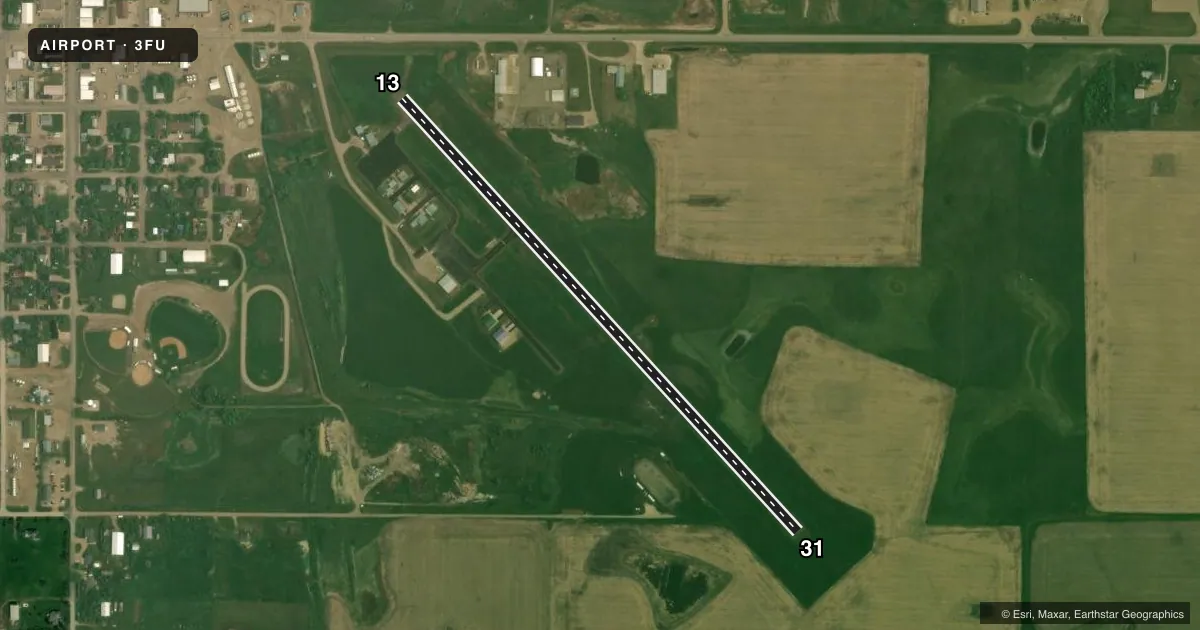
Airport sketch
Runways drawn to scale from FAA survey coordinates, rendered over satellite imagery. Not for navigation.
Approaches & charts
Services on the field
Fuel grades, oxygen, maintenance, ramp storage and lighting — as declared to the FAA by the airport operator.
Fuel & services
- Fuel
- Not available
- Oxygen (bottled)
- Not available
- Oxygen (bulk)
- Not available
- Airframe repair
- Minor
- Power plant repair
- Minor
- Other services
- AGRI,INSTR
Ramp & ground
- Transient storage
- Tie-down
- Landing fee
- No fee published
- Customs
- Not available
- Beacon schedule
- SS-SR
- Beacon
- White / Green (civil land)(WG)
- Wind indicator
- Lighted
- Segmented circle
- No
Fuel & FBOs
Cheapest 100LL and Jet A on the field and nearby. Always confirm with the FBO before taxi.
Airport notes
Surface conditions, obstructions, local procedures, lighting outages and other notes published with each FAA cycle.
General notes
- RY 13 4 FT FENCE 200 FT RIGHT 415 FT FROM THR; TOP OF FENCE BLO RY END ELEVATION.
- WILDLIFE AND WATERFOWL ON AND INVOF AIRPORT.
- FOR CD CTC MINNEAPOLIS ARTCC AT 651-463-5588.
Approach & departure obstructions
- 13APCH RATIO 50:1 TO DSPLCD THLD.
Other notes
- AUTOMATED UNICOM. ADZY ALSO AVBL BY CALLING 617-262-3825.
VFR map & nearby airports
VFR sectional. Tap any ICAO chip to open that airport.
Key facts · 3FU
Answer card- ICAO
- 3FU
- Name
- FAULKTON MUNI
- Location
- FAULKTON, SOUTH DAKOTA
- Elevation
- 1,571 ft MSL
- Traffic pattern altitude
- 2,571 ft MSL (1,000 AGL)
- Control tower
- Non-towered (use CTAF)
- Total runways
- 1
- Longest runway
- 13/31 · 3,249 ft
- Published ILS approaches
- 0
- Published frequencies
- 1
- Magnetic variation
- 8°
- Current flight rules
- VFR
- Current wind
- 010° at 6 kt
- Favored runway now
- RWY 31
Faulkton Muni is in Faulkton, South Dakota. The field elevation is 1,571 ft MSL. It has one runway, 13/31, which is 3,249 ft long and asphalt. There is no control tower. CTAF is 122.9. No ILS approaches are published here.
For pattern work, the published pattern altitude is not listed. Use the standard 1,000 ft AGL pattern for light piston operations unless current local guidance says otherwise. Runway headings are magnetic. The field sits in open country. Watch for wildlife and waterfowl on and near the airport. That is a real factor here.
Runway 13 has a fence off the right side near the approach end. The Chart Supplement also notes a 50 to 1 approach ratio to the displaced threshold on that end. Automated UNICOM is available. Advisory service is also available by phone at 617-262-3825. For clearance delivery, contact Minneapolis ARTCC at 651-463-5588. There are no on-field FBOs listed. Verify fuel and service availability with the airport operator or on the field by radio before you go. For a first trip, plan for a non-towered arrival. Keep an eye out for wildlife. Review the current Chart Supplement before departure.