METAR & TAF KMKA
KMKA does not publish a METAR.
Showing the nearest reporting station: KHON (HURON RGNL) · 32.4 NM away. Conditions at KMKA may differ.
METAR · KHON
Observed 12:55Z
KHON 271255Z AUTO 33005KT 8SM CLR 23/22 A2984 RMK AO2 SLP093 T02330222
- Wind
- 330° @ 5 kt
- Visibility
- 8 SM
- Temp / Dew
- 23°C / 22°C
- Altimeter
- 29.84 inHg
- Clouds
- CLR
- Density alt
- 3,006 ft
- Ceiling
- Unlimited
- Rules
- VFR
Airport info & contacts
Manager on record, flight service, ARTCC, attendance schedule and pattern altitude — published by the FAA and refreshed every 28 days.
Location
- From city
- 2 NM E
- VFR sectional
- TWIN CITIES
- ARTCC
- ZMP · MINNEAPOLIS
- NOTAM facility
- HON (NOTAM-D)
Airport manager
- Name
- TERRY MANNING
- Phone
- 605-853-2705
- Address
- 120 W 2ND ST, MILLER SD 57362
Flight service · Hours
- FSS HON
- HURON1-800-WX-BRIEF
- Attendance
- IREG
Frequencies
Tap any row to copy the frequency to your clipboard.
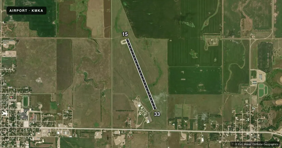
Runways & pattern
Full pagePattern entry · RWY 33
LEFT TRAFFICRunway end performance
| End | TORA | TODA | ASDA | LDA | VGSI | Approach lights | Obstruction |
|---|---|---|---|---|---|---|---|
| 15 | — | — | — | — | PAPI 2-box left(3°) | — | — |
| 33 | — | — | — | — | PAPI 2-box left(3°) | — | — |
Declared distances in feet. TORA = takeoff run available, TODA = takeoff distance, ASDA = accelerate-stop, LDA = landing distance.
Airport sketch
Runways drawn to scale from FAA survey coordinates, rendered over satellite imagery. Not for navigation.
Approaches & charts
Services on the field
Fuel grades, oxygen, maintenance, ramp storage and lighting — as declared to the FAA by the airport operator.
Fuel & services
- Fuel
- 100LL
- Oxygen (bottled)
- Not available
- Oxygen (bulk)
- Not available
- Airframe repair
- Minor
- Power plant repair
- Minor
- Other services
- AGRI
Ramp & ground
- Transient storage
- Tie-down
- Hangar
- Landing fee
- No fee published
- Customs
- Not available
- Lighting schedule
- SEE RMK
- Wind indicator
- Lighted
- Segmented circle
- No
Fuel & FBOs
Cheapest 100LL and Jet A on the field and nearby. Always confirm with the FBO before taxi.
Airport notes
Surface conditions, obstructions, local procedures, lighting outages and other notes published with each FAA cycle.
General notes
- GCO AVBL ON FREQ 121.725 (4 CLICKS TO MINNEAPOLIS CENTER AND 6 CLICKS TO FLT SVCS)
- FOR CD IF UNA VIA GCO CTC MINNEAPOLIS ARTCC AT 651-463-5588.
Lighting notes
- ACTVT PAPI RWYS 15 & 33; MIRL RWY 15/33 - 122.8.
Fuel notes
- 100LLFOR FUEL CALL 605-204-0565, 605-204-0730.
VFR map & nearby airports
VFR sectional. Tap any ICAO chip to open that airport.
Key facts · KMKA
Answer card- ICAO
- KMKA
- Name
- MILLER MUNI
- Location
- MILLER, SOUTH DAKOTA
- Elevation
- 1,569.6 ft MSL
- Traffic pattern altitude
- 2,569.6 ft MSL (1,000 AGL)
- Control tower
- Non-towered (use CTAF)
- Total runways
- 1
- Longest runway
- 15/33 · 3,601 ft
- Published ILS approaches
- 0
- Published frequencies
- 1
- Magnetic variation
- 7°
- Current flight rules
- VFR
- Current wind
- 330° at 5 kt
- Favored runway now
- RWY 33
Miller Muni is in Miller, South Dakota. The field elevation is 1,569.6 ft MSL. KMKA has one runway. Runway 15/33 is 3,601 ft long with concrete pavement. The airport is non-towered. CTAF is 122.9. Published remarks also note a ground communications outlet on 121.725 with four clicks to Minneapolis Center. Six clicks go to flight services. If you need clearance delivery and cannot use the ground communications outlet, contact Minneapolis ARTCC at 651-463-5588.
No ILS approaches are published here. The pattern altitude is not published in the facts, so use the standard 1,000 ft AGL for light piston aircraft unless the current FAA Chart Supplement says otherwise. The runway has medium intensity lights. PAPI is installed for runways 15 and 33. Fuel remarks say to call 605-204-0565 or 605-204-0730 for 100LL. There are no on-field FBOs listed in the facts, so verify fuel and service details before you go.
For a first-time arrival, the main things to plan for are the non-towered pattern, the single runway layout and the lack of published ILS. Check the current FAA Chart Supplement for any noise or local operating notes before flying in.