METAR & TAF 1V2
1V2 does not publish a METAR.
Showing the nearest reporting station: KAIA (ALLIANCE MUNI) · 46.2 NM away. Conditions at 1V2 may differ.
METAR · KAIA
Observed 15:53Z
KAIA 271553Z AUTO 21011KT 10SM CLR 30/16 A3003 RMK AO2 LTG DSNT SE AND S SLP111 T03000156 $
- Wind
- 210° @ 11 kt
- Visibility
- 10 SM
- Temp / Dew
- 30°C / 16°C
- Altimeter
- 30.03 inHg
- Clouds
- CLR
- Density alt
- 6,297 ft
- Ceiling
- Unlimited
- Rules
- VFR
Airport info & contacts
Manager on record, flight service, ARTCC, attendance schedule and pattern altitude — published by the FAA and refreshed every 28 days.
Location
- From city
- 1 NM NW
- VFR sectional
- CHEYENNE
- ARTCC
- ZDV · DENVER
- NOTAM facility
- OLU (NOTAM-D)
Airport manager
- Name
- BRIAN BRENNEMANN
- Phone
- (308) 458-2411
- Address
- 64855 BRENNEMAN ROAD, HYANNIS NE 69350-0302
Flight service · Hours
- FSS OLU
- COLUMBUS1-800-WX-BRIEF
- Attendance
- Unattended
Frequencies
Tap any row to copy the frequency to your clipboard.
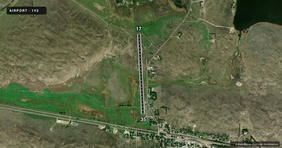
Runways & pattern
Full pagePattern entry · RWY 17
LEFT TRAFFICRunway end performance
| End | TORA | TODA | ASDA | LDA | VGSI | Approach lights | Obstruction |
|---|---|---|---|---|---|---|---|
| 35 | — | — | — | — | — | — | 167', tree, 2117' from thr, 178' R of cntrln, slope 11 |
Declared distances in feet. TORA = takeoff run available, TODA = takeoff distance, ASDA = accelerate-stop, LDA = landing distance.
Airport sketch
Runways drawn to scale from FAA survey coordinates, rendered over satellite imagery. Not for navigation.
Approaches & charts
Services on the field
Fuel grades, oxygen, maintenance, ramp storage and lighting — as declared to the FAA by the airport operator.
Fuel & services
- Fuel
- 100LL
- Oxygen (bottled)
- Not available
- Oxygen (bulk)
- Not available
- Airframe repair
- Not available
- Power plant repair
- Not available
Ramp & ground
- Transient storage
- Tie-down
- Landing fee
- No fee published
- Customs
- Not available
- Lighting schedule
- SEE RMK
- Beacon schedule
- SS-SR
- Beacon
- White / Green (civil land)(WG)
- Wind indicator
- Yes
- Segmented circle
- No
Fuel & FBOs
Cheapest 100LL and Jet A on the field and nearby. Always confirm with the FBO before taxi.
Airport notes
Surface conditions, obstructions, local procedures, lighting outages and other notes published with each FAA cycle.
General notes
- FOR CD CTC DENVER ARTCC AT 303-651-4257.
Lighting notes
- BCN 2950' SE & TWR ON HILL EAST OF ARPT.
- DUSK-DAWN. ACTVT MIRL RY 17/35 - CTAF.
Fuel notes
- 100LL24HR CREDIT CARD AVBL.
Approach & departure obstructions
- 17RWY 17 CLOSE-IN OBSTN APCH SLOPE 22:1 DUE TO PUBLIC ROAD CLNC 16 FT ABOVE RWY END ELEV 409 FT FROM DSPLCD THR
- 35RWY 35 CLOSE-IN OBSTN APCH RATIO 24:1 DUE TO 34 FT POLE 822 FT FROM DSPLCD THR.
- 35APCH RATIO 16:1 DUE TO 167 FT TREE 2792 FT FROM DSPLCD THR.
Other notes
- OWNERPHONE NO FOR GRANT COUNTY CLERK.
VFR map & nearby airports
VFR sectional. Tap any ICAO chip to open that airport.
Key facts · 1V2
Answer card- ICAO
- 1V2
- Name
- GRANT COUNTY
- Location
- HYANNIS, NEBRASKA
- Elevation
- 3,737 ft MSL
- Traffic pattern altitude
- 4,737 ft MSL (1,000 AGL)
- Control tower
- Non-towered (use CTAF)
- Total runways
- 1
- Longest runway
- 17/35 · 3,975 ft
- Published ILS approaches
- 0
- Published frequencies
- 1
- Magnetic variation
- 10°
- Current flight rules
- VFR
- Current wind
- 210° at 11 kt
- Favored runway now
- RWY 17
Grant County Airport sits near Hyannis, Nebraska. Field elevation is 3,737 ft MSL. The airport has one runway. Runway 17/35 is 3,975 ft long and asphalt. There is no control tower. CTAF is 122.9.
No ILS approaches are published here. Pattern altitude is not published, so use the standard 1,000 ft AGL for light piston operations unless the current FAA Chart Supplement says otherwise. That puts the normal pattern reference at 4,737 ft MSL based on the field elevation. Runway 17/35 has medium intensity lights. They are controlled by CTAF and work from dusk to dawn.
Sandhill Oil Co. is on the field. It carries 100LL. Published remarks say 100LL is available 24 hours by credit card. The field also has close-in obstacle notes on both runway ends. Runway 17 has a road near the approach path. Runway 35 has a pole and a tree noted on approach. The airport also notes the beacon is southeast of the field and the tower sits on a hill east of the airport. For clearance delivery, contact Denver ARTCC. At this elevation, expect thinner air and plan for performance, especially on warm days. Check the current FAA Chart Supplement before flight for any changes to remarks or pattern guidance.