METAR & TAF KTIF
Current METAR
Observed 10:35Z
KTIF 271035Z AUTO 29009KT 10SM CLR 22/20 A2993 RMK AO2 T02210200
- Wind
- 290° @ 9 kt
- Visibility
- 10 SM
- Temp / Dew
- 22°C / 20°C
- Altimeter
- 29.93 inHg
- Clouds
- CLR
- Density alt
- 4,455 ft
- Ceiling
- Unlimited
- Rules
- VFR
Airport info & contacts
Manager on record, flight service, ARTCC, attendance schedule and pattern altitude — published by the FAA and refreshed every 28 days.
Location
- From city
- 1 NM S
- VFR sectional
- OMAHA
- ARTCC
- ZDV · DENVER
- NOTAM facility
- TIF (NOTAM-D)
Airport manager
- Name
- JACK JOHNSTON
- Phone
- 308-645-9016
- Address
- P.O. BOX 22, THEDFORD NE 69166-0022
Flight service · Hours
- FSS OLU
- COLUMBUS1-800-WX-BRIEF
- Attendance
- Unattended
Frequencies
Tap any row to copy the frequency to your clipboard.
Runways & pattern
Full pagePattern entry · RWY 29
LEFT TRAFFICRunway end performance
| End | TORA | TODA | ASDA | LDA | VGSI | Approach lights | Obstruction |
|---|---|---|---|---|---|---|---|
| 11 | — | — | — | — | PAPI 2-box left(3°) | — | — |
| 29 | — | — | — | — | PAPI 2-box left(3°) | — | 31', tree, 756' from thr, 306' R of cntrln, slope 17 |
Declared distances in feet. TORA = takeoff run available, TODA = takeoff distance, ASDA = accelerate-stop, LDA = landing distance.
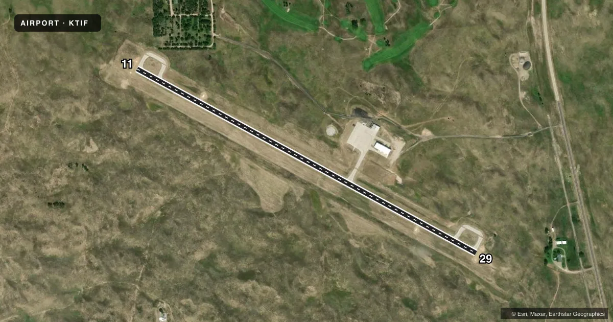
Airport sketch
Runways drawn to scale from FAA survey coordinates, rendered over satellite imagery. Not for navigation.
Approaches & charts
Services on the field
Fuel grades, oxygen, maintenance, ramp storage and lighting — as declared to the FAA by the airport operator.
Fuel & services
- Fuel
- 100LLA
Ramp & ground
- Transient storage
- Tie-down
- Hangar
- Lighting schedule
- SEE RMK
- Beacon schedule
- SS-SR
- Beacon
- White / Green (civil land)(WG)
- Wind indicator
- Yes
- Segmented circle
- No
Fuel & FBOs
Cheapest 100LL and Jet A on the field and nearby. Always confirm with the FBO before taxi.
Airport notes
Surface conditions, obstructions, local procedures, lighting outages and other notes published with each FAA cycle.
General notes
- COURTESY VAN AVBL.
- FOR CD CTC DENVER ARTCC AT 303-651-4257.
Lighting notes
- ACTVT REIL RWY 11 & 29; PAPI RWY 11 & 29; MIRL RWY 11/29 -CTAF.
Fuel notes
- 100LLFUEL AVBL H24 VIA CREDIT CARD.
Approach & departure obstructions
- 2914 FT TREE 107 FT FM RWY END 280 FT R.
- 11APCH 23:1 DUE TO HILL 18 FT ABV & 628 FT FM RWY END; 281 FT R OFFSET.
Other notes
- PRVDD MAINTAIN CLEAR 20:1 APCH & CLEAR 7:1 TRSNL SFC.
- FOR HNGR AVBLTY CALL 308-645-9016.
- OWNERCHAIRMAN OF THOMAS CO ARPT AUTH CELL 308-645-9016.
VFR map & nearby airports
VFR sectional. Tap any ICAO chip to open that airport.
Key facts · KTIF
Answer card- ICAO
- KTIF
- Name
- THOMAS COUNTY
- Location
- THEDFORD, NEBRASKA
- Elevation
- 2,925.4 ft MSL
- Traffic pattern altitude
- 3,925.4 ft MSL (1,000 AGL)
- Control tower
- Non-towered (use CTAF)
- Total runways
- 1
- Longest runway
- 11/29 · 4,402 ft
- Published ILS approaches
- 0
- Published frequencies
- 1
- Magnetic variation
- 8°
- Current flight rules
- VFR
- Current wind
- 290° at 9 kt
- Favored runway now
- RWY 29
Thomas County Airport sits in Thedford, Nebraska. Field elevation is 2,925.4 ft MSL. The airport has one runway. Runway 11/29 is 4,402 ft long with a concrete surface. There is no control tower, so CTAF is 122.9 for traffic work. No ILS approaches are published here.
Pattern altitude is not published. Use the standard 1,000 ft AGL pattern for light piston operations unless the current Chart Supplement says otherwise. The field has runway end identifier lights, PAPI on both ends and medium intensity runway lights that are controlled by CTAF. 100LL is available 24 hours a day by credit card. The on-field FBO is Thomas County Airport. It carries AVGAS_100LL and JET_A_PRIST. Call the FBO at (308) 645-2233 for current service details.
This is a high-elevation field, so performance planning matters. The published remarks also note an obstruction issue on the 11 end. The approach slope there is affected by a hill near the runway end. Check the current Chart Supplement before you go. Clearance delivery is handled through Denver Center. A courtesy van is available. If you need hangar space, call the airport contact before arrival.