METAR & TAF KAIA
Current METAR
Observed 04:53Z
KAIA 270453Z AUTO 09009KT 10SM CLR 29/12 A2996 RMK AO2 LTG DSNT W SLP079 T02890117
- Wind
- 090° @ 9 kt
- Visibility
- 10 SM
- Temp / Dew
- 29°C / 12°C
- Altimeter
- 29.96 inHg
- Clouds
- CLR
- Density alt
- 6,504 ft
- Ceiling
- Unlimited
- Rules
- VFR
Airport info & contacts
Manager on record, flight service, ARTCC, attendance schedule and pattern altitude — published by the FAA and refreshed every 28 days.
Location
- From city
- 3 NM SE
- VFR sectional
- CHEYENNE
- ARTCC
- ZDV · DENVER
- NOTAM facility
- AIA (NOTAM-D)
Airport manager
- Name
- MS LYNN PLACEK
- Phone
- 308-762-4512
- Address
- 5631 SARPY ROAD, PO BOX D, ALLIANCE NE 69301
Flight service · Hours
- FSS OLU
- COLUMBUS1-800-WX-BRIEF
- Attendance
- ALL
Frequencies
Tap any row to copy the frequency to your clipboard.
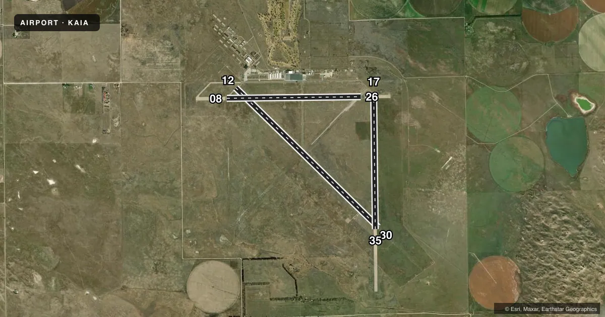
Runways & pattern
Full pagePattern entry · RWY 08
LEFT TRAFFIC| Runway | Heading (°M) | Length | Surface | Traffic |
|---|---|---|---|---|
| 12/30 | 127° / 307° | 9,203 ft | ASPH | Standard L |
| 17/35 | 172° / 352° | 6,311 ft | ASPH | Standard L |
| 08/26Favored | 82° / 262° | 6,190 ft | ASPH | Standard L |
Runway end performance
| End | TORA | TODA | ASDA | LDA | VGSI | Approach lights | Obstruction |
|---|---|---|---|---|---|---|---|
| 12 | 9,203' | 9,203' | 9,203' | 9,203' | VASI 4-box left(3°) | — | — |
| 30 | 9,203' | 9,203' | 9,203' | 9,203' | PAPI 4-box left(3°) | MALSR | — |
| 17 | 6,311' | 6,311' | 6,311' | 6,311' | — | — | — |
| 35 | 6,311' | 6,311' | 6,311' | 6,311' | — | — | — |
| 08 | 6,190' | 6,190' | 6,190' | 6,190' | — | — | — |
| 26 | 6,190' | 6,190' | 6,190' | 6,190' | — | — | — |
Declared distances in feet. TORA = takeoff run available, TODA = takeoff distance, ASDA = accelerate-stop, LDA = landing distance.
Airport sketch
Runways drawn to scale from FAA survey coordinates, rendered over satellite imagery. Not for navigation.
Approaches & charts
ILS · 1
Services on the field
Fuel grades, oxygen, maintenance, ramp storage and lighting — as declared to the FAA by the airport operator.
Fuel & services
- Fuel
- 100LLA
- Oxygen (bottled)
- Not available
- Airframe repair
- Major
- Power plant repair
- Major
- Other services
- AGRI,INSTR,RNTL,SALES
Ramp & ground
- Transient storage
- Tie-down
- Hangar
- Landing fee
- No fee published
- Customs
- Not available
- Lighting schedule
- SEE RMK
- Beacon schedule
- SS-SR
- Beacon
- White / Green (civil land)(WG)
- Wind indicator
- Lighted
- Segmented circle
- Yes
Fuel & FBOs
Cheapest 100LL and Jet A on the field and nearby. Always confirm with the FBO before taxi.
Airport notes
Surface conditions, obstructions, local procedures, lighting outages and other notes published with each FAA cycle.
General notes
- ULTRALIGHT & GLIDER OPNS ON & INVOF ARPT.
- AERIAL SPRAYING OPNS ON & INVOF ARPT.
- RY 08/26 DESIGNATED CALM WIND.
- HAYING OPNS ON INTERIOR OF ARPT DURG SUMMER MONTHS.
- OCCASIONAL USE BY ACFT WITH NO RADIO.
- BACK TAXIING.
- MIGRATORY WATERFOWL ON & INVOF ARPT.
- FOR CD IF UNA TO CTC ON FSS FREQ, CTC DENVER ARTCC AT 303-651-4257.
Lighting notes
- ACTVT MALSR RWY 30; REIL RWY 12; VASI RWY 12; PAPI RWY 30 & MIRL RWY 12/30 & 08/26 -CTAF.
Runway surface & condition
- 08/26PCR VALUE: 39/R/B/W/T
- 12/30PCR VALUE: 39/R/B/W/T
- 17/35PCR VALUE: 39/R/B/W/T
- 17/35RWY 17/35 NOT AVBL FOR PART 121/PART 380 OPS WITH SKED PAX CARRYING OPS MORE THAN 9 PAX SEATS AND NON-SKED PAX CARRYING OPS MORE THAN 30 PAX SEATS.
VFR map & nearby airports
VFR sectional. Tap any ICAO chip to open that airport.
Key facts · KAIA
Answer card- ICAO
- KAIA
- Name
- ALLIANCE MUNI
- Location
- ALLIANCE, NEBRASKA
- Elevation
- 3,930.6 ft MSL
- Traffic pattern altitude
- 4,930.6 ft MSL (1,000 AGL)
- Control tower
- Non-towered (use CTAF)
- Total runways
- 3
- Longest runway
- 12/30 · 9,203 ft
- Published ILS approaches
- 1
- Published frequencies
- 2
- Magnetic variation
- 7°
- Current flight rules
- VFR
- Current wind
- 090° at 9 kt
- Favored runway now
- RWY 08
Alliance Muni sits in Alliance, Nebraska. The field elevation is 3,930.6 ft MSL. It has three asphalt runways. The longest is runway 12/30 at 9,203 ft. There is no control tower. CTAF and UNICOM are both 123.0.
Runway 30 has the ILS. Published lighting notes show MALSR on runway 30. Runway 12 has REIL and VASI. Runway 30 has PAPI. Medium intensity runway lighting is published for runways 12/30 and 08/26. Runway 08/26 is listed for calm wind conditions. Back taxiing is required. Plan your ground work carefully.
Pattern altitude is not published. Use the standard 1,000 ft AGL for light piston operations unless the current Chart Supplement says otherwise. That puts the traffic pattern at about 4,930.6 ft MSL. Heartland Aviation is on the field. It carries 100LL and Jet A with Prist. If you need clearance delivery and cannot reach Flight Service, the remarks say to contact Denver ARTCC. Expect some mixed traffic. The airport notes haying, aerial spraying, occasional no-radio use and migratory waterfowl in and around the field. Runway 17/35 is also restricted for certain large passenger-carrying operations.