METAR & TAF 2V6
Current METAR
Observed 12:14Z
K2V6 271214Z AUTO 02004KT 10SM CLR 23/17 A2999 RMK AO2
- Wind
- 020° @ 4 kt
- Visibility
- 10 SM
- Temp / Dew
- 23°C / 17°C
- Altimeter
- 29.99 inHg
- Clouds
- CLR
- Density alt
- 6,004 ft
- Ceiling
- Unlimited
- Rules
- VFR
Airport info & contacts
Manager on record, flight service, ARTCC, attendance schedule and pattern altitude — published by the FAA and refreshed every 28 days.
Location
- From city
- 1 NM SE
- VFR sectional
- CHEYENNE
- ARTCC
- ZDV · DENVER
- NOTAM facility
- DEN (NOTAM-D)
Airport manager
- Name
- ROBERT MOORE
- Phone
- 970-848-3878
- Address
- 321 S. MAIN ST., YUMA CO 80759
Flight service · Hours
- FSS DEN
- DENVER1-800-WX-BRIEF
- Attendance
- MON-SAT · DALGT
Frequencies
Tap any row to copy the frequency to your clipboard.
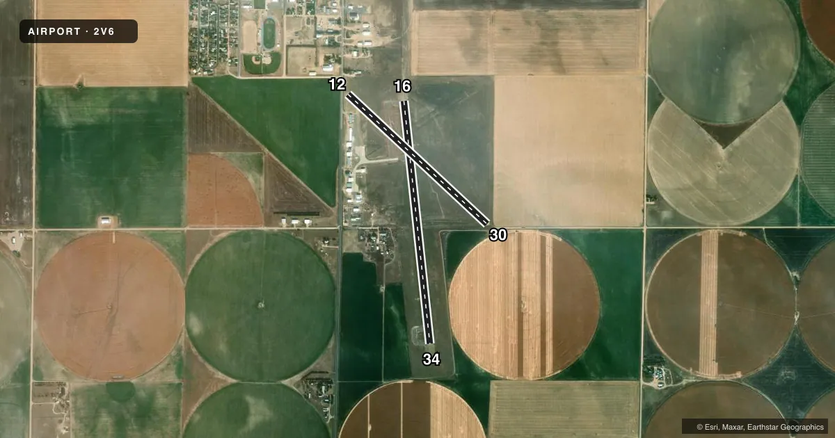
Runways & pattern
Full pagePattern entry · RWY 34
RIGHT TRAFFIC| Runway | Heading (°M) | Length | Surface | Traffic |
|---|---|---|---|---|
| 16/34Favored | 166° / 346° | 4,201 ft | ASPH | 34 R |
| 12/30 | 126° / 306° | 3,277 ft | ASPH-GRVL | 12 R |
Runway end performance
| End | TORA | TODA | ASDA | LDA | VGSI | Approach lights | Obstruction |
|---|---|---|---|---|---|---|---|
| 16 | — | — | — | — | PAPI 2-box left(3°) | — | 15', tree, 740' from thr, 85' R of cntrln, slope 36 |
| 34 | — | — | — | — | PAPI 2-box left(3°) | — | 13', other, 632' from thr, 124' R of cntrln, slope 33 |
| 12 | — | — | — | — | — | — | 18', road, 78' from thr, 16' R of cntrln, slope 4 |
| 30 | — | — | — | — | — | — | 13', road, 194' from thr, 0' R of cntrln, slope 14 |
Declared distances in feet. TORA = takeoff run available, TODA = takeoff distance, ASDA = accelerate-stop, LDA = landing distance.
Airport sketch
Runways drawn to scale from FAA survey coordinates, rendered over satellite imagery. Not for navigation.
Approaches & charts
Services on the field
Fuel grades, oxygen, maintenance, ramp storage and lighting — as declared to the FAA by the airport operator.
Fuel & services
- Fuel
- 100LLJ
- Oxygen (bottled)
- Not available
- Oxygen (bulk)
- Not available
- Airframe repair
- Not available
- Power plant repair
- Not available
- Other services
- AGRI,AMB
Ramp & ground
- Transient storage
- Tie-down
- Hangar
- Landing fee
- No fee published
- Customs
- Not available
- Lighting schedule
- SEE RMK
- Beacon schedule
- SS-SR
- Beacon
- White / Green (civil land)(WG)
- Wind indicator
- Lighted
- Segmented circle
- Yes
Fuel & FBOs
Cheapest 100LL and Jet A on the field and nearby. Always confirm with the FBO before taxi.
Airport notes
Surface conditions, obstructions, local procedures, lighting outages and other notes published with each FAA cycle.
General notes
- TWYS MKD WITH BLUE & YELLOW REFLECTORS.
- RWY 12/30 SOFT WHEN WET.
- RWY 30 HAS 2 FT DITCH AT THLD 0B; 4 FT FENCE 50 FT FM THLD 0B.
- BE ALERT, INTENSIVE USAF STUDENT TRNG INVOF COLORADO SPRINGS & PUEBLO.
- FOR CD CTC DENVER ARTCC AT 303-651-4257.
Lighting notes
- MIRL RWY 16/34 PRESET MED INTS DUSK-DAWN. ACTVT REIL RWY 16/34 - CTAF. PCL NOT AVBL FOR PAPI SYS.
Fuel notes
- 100LLSELF SERVE
- JSELF SERVE
Runway surface & condition
- 12/30RWY 12/30 CNTR 650 FT ASPH, RMNDR GRVL.
Approach & departure obstructions
- 16PAPI UNUSBL BYD 8 DEG RIGHT OF CNTRLN.
- 16INTERMITTENT +12 FT IRRIGATION PIVOT
Other notes
- MANAGERCITY MANAGER.
VFR map & nearby airports
VFR sectional. Tap any ICAO chip to open that airport.
Key facts · 2V6
Answer card- ICAO
- 2V6
- Name
- YUMA MUNI
- Location
- YUMA, COLORADO
- Elevation
- 4,137.7 ft MSL
- Traffic pattern altitude
- 5,137.7 ft MSL (1,000 AGL)
- Control tower
- Non-towered (use CTAF)
- Total runways
- 2
- Longest runway
- 16/34 · 4,201 ft
- Published ILS approaches
- 0
- Published frequencies
- 2
- Magnetic variation
- 7°
- Current flight rules
- VFR
- Current wind
- 020° at 4 kt
- Favored runway now
- RWY 34
Yuma Muni sits in Yuma, Colorado. The field elevation is 4,137.7 ft MSL. It has two runways. The longest is Runway 16/34 at 4,201 ft. This is an uncontrolled airport with CTAF and UNICOM both on 122.8. No ILS approaches are published here.
The pattern altitude is not published. Use 1,000 ft AGL as the standard light piston pattern unless the current Chart Supplement or local procedures say otherwise. Runway 16/34 has medium intensity lights preset from dusk to dawn. The runway end identifier lights are tied to CTAF. The PAPI on Runway 16 is not usable more than 8 degrees right of centerline. Runway 16 also has an intermittent 12-foot irrigation pivot obstruction. Runway 12/30 is part asphalt and part gravel. The center 650 ft is asphalt. The rest is gravel. It is also soft when wet.
There are no on-field FBOs listed. Self-serve 100LL is published. Jet fuel is also self-serve. For clearance delivery, contact Denver ARTCC at 303-651-4257. Expect a rural Colorado field with high elevation performance planning in mind. The remarks also call out intensive USAF student training in the Colorado Springs and Pueblo area. Stay sharp on frequency discipline and traffic scanning.