METAR & TAF KSYF
Current METAR
Observed 13:15Z
KSYF 271315Z AUTO 03007G16KT 10SM CLR 27/19 A2992 RMK AO2
- Wind
- 030° @ 7G16 kt
- Visibility
- 10 SM
- Temp / Dew
- 27°C / 19°C
- Altimeter
- 29.92 inHg
- Clouds
- CLR
- Density alt
- 5,693 ft
- Ceiling
- Unlimited
- Rules
- VFR
Airport info & contacts
Manager on record, flight service, ARTCC, attendance schedule and pattern altitude — published by the FAA and refreshed every 28 days.
Location
- From city
- 1 NM S
- VFR sectional
- WICHITA
- ARTCC
- ZDV · DENVER
- NOTAM facility
- ICT (NOTAM-D)
Airport manager
- Name
- MICHAEL HANSON
- Phone
- 785-332-8844
- Address
- 212 E. WASHINGTON ST, PO BOX 517, ST. FRANCIS KS 67756
Flight service · Hours
- FSS ICT
- WICHITA1-800-WX-BRIEF
Frequencies
Tap any row to copy the frequency to your clipboard.
Runways & pattern
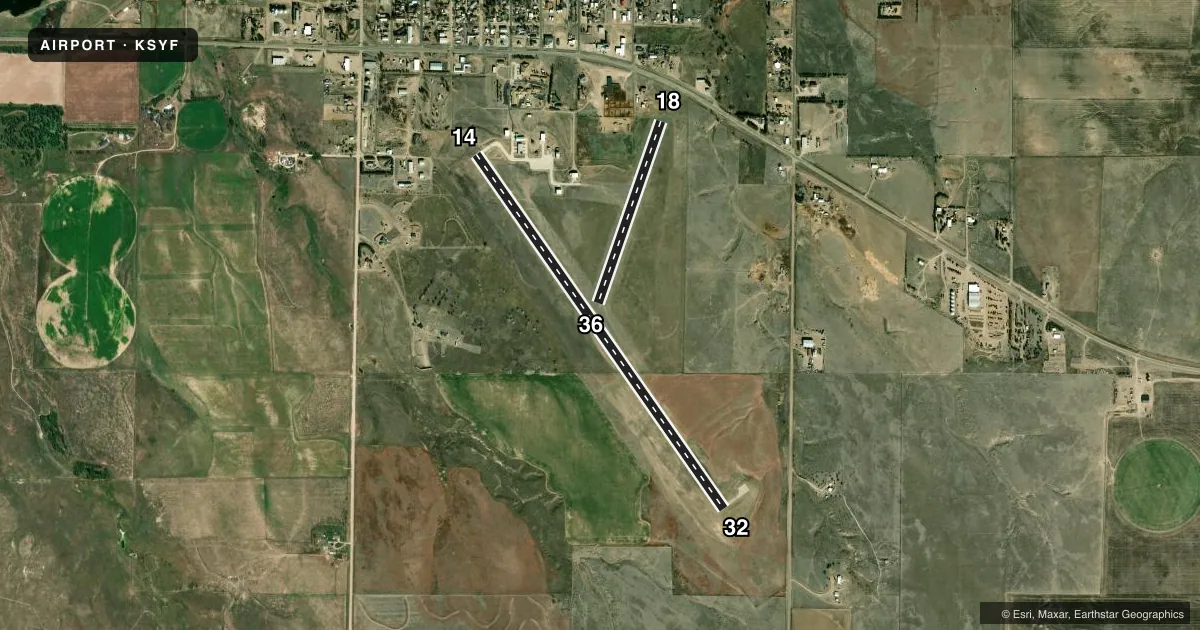
Full pagePattern entry · RWY 36
LEFT TRAFFIC| Runway | Heading (°M) | Length | Surface | Traffic |
|---|---|---|---|---|
| 14/32 | 139° / 319° | 5,200 ft | CONC | Standard L |
| 18/36Favored | 193° / 13° | 2,313 ft | TURF | Standard L |
Runway end performance
| End | TORA | TODA | ASDA | LDA | VGSI | Approach lights | Obstruction |
|---|---|---|---|---|---|---|---|
| 14 | 5,200' | 5,200' | 5,200' | 5,000' | — | — | 36', trees, 662' from thr, 214' R of cntrln, slope 12 |
| 32 | 5,200' | 5,200' | 5,200' | 5,200' | — | — | — |
| 18 | — | — | — | — | — | — | 15', road, 55' from thr, 0' R of cntrln, slope 3 |
Declared distances in feet. TORA = takeoff run available, TODA = takeoff distance, ASDA = accelerate-stop, LDA = landing distance.
Airport sketch
Runways drawn to scale from FAA survey coordinates, rendered over satellite imagery. Not for navigation.
Approaches & charts
Services on the field
Fuel grades, oxygen, maintenance, ramp storage and lighting — as declared to the FAA by the airport operator.
Fuel & services
- Fuel
- 100LL
- Other services
- AFRT,AGRI,CHTR,INSTR,RNTL
Ramp & ground
- Transient storage
- Tie-down
- Landing fee
- No fee published
- Lighting schedule
- SEE RMK
- Beacon schedule
- SS-SR
- Beacon
- White / Green (civil land)(WG)
- Wind indicator
- Lighted
- Segmented circle
- No
Fuel & FBOs
Cheapest 100LL and Jet A on the field and nearby. Always confirm with the FBO before taxi.
Airport notes
Surface conditions, obstructions, local procedures, lighting outages and other notes published with each FAA cycle.
General notes
- FOR CD CTC DENVER ARTCC AT 303-651-4257.
Lighting notes
- ACTVT MIRL RWY 14/32 - CTAF.
Approach & departure obstructions
- 1835 FT PLINE AT 450 FT 0B.
Other notes
- PRVDD THE APCH TO EACH RWY IS MAINTD FOR A MIN 20:1 GLIDE SLOPE AND THE TRSNL SFC BE MAINTD FOR A 7:1 SLOPE.
VFR map & nearby airports
VFR sectional. Tap any ICAO chip to open that airport.
Key facts · KSYF
Answer card- ICAO
- KSYF
- Name
- CHEYENNE COUNTY MUNI
- Location
- ST FRANCIS, KANSAS
- Elevation
- 3,429.5 ft MSL
- Traffic pattern altitude
- 4,429.5 ft MSL (1,000 AGL)
- Control tower
- Non-towered (use CTAF)
- Total runways
- 2
- Longest runway
- 14/32 · 5,200 ft
- Published ILS approaches
- 0
- Published frequencies
- 2
- Magnetic variation
- 6°
- Current flight rules
- VFR
- Current wind
- 030° at 7 kt
- Favored runway now
- RWY 36
Cheyenne County Muni sits in St. Francis, Kansas. The field elevation is 3,429.5 ft MSL. It has two runways. The longest is 14/32 at 5,200 ft of concrete. Runway 18/36 is 2,313 ft of turf. There is no control tower. CTAF and UNICOM are both 122.8. No ILS approaches are published here.
The pattern altitude is not published. Use 1,000 ft AGL for light piston operations unless the current Chart Supplement says otherwise. That puts the pattern at about 4,429.5 ft MSL. The airport sits in open country with high field elevation. Expect density altitude to matter on warm days. Runway 18 has a published obstacle note. A 35 ft power line sits 450 ft off the departure end on the outbound bearing. Runway 14/32 has medium intensity lights that are activated by radio on the CTAF.
Nutrien Ag Solutions is on the field. It carries AVGAS 100LL. For clearance delivery, contact Denver ARTCC at 303-651-4257. The published remarks also call out a minimum 20 to 1 glide slope surface near the runways. Check the current Chart Supplement before you go. That is the best place to confirm any current operational notes before a first arrival.