METAR & TAF KITR
Current METAR
Observed 22:53Z
KITR 262253Z AUTO 35008KT 10SM CLR 42/09 A2993 RMK AO2 SLP061 T04170089 $
- Wind
- 350° @ 8 kt
- Visibility
- 10 SM
- Temp / Dew
- 42°C / 9°C
- Altimeter
- 29.93 inHg
- Clouds
- CLR
- Density alt
- 8,458 ft
- Ceiling
- Unlimited
- Rules
- VFR
Airport info & contacts
Manager on record, flight service, ARTCC, attendance schedule and pattern altitude — published by the FAA and refreshed every 28 days.
Location
- From city
- 3 NM S
- VFR sectional
- WICHITA
- ARTCC
- ZDV · DENVER
- NOTAM facility
- ITR (NOTAM-D)
Airport manager
- Name
- DANIEL MELIA
- Phone
- 719-346-5352
- Address
- 14111 HWY 385, BURLINGTON CO 80807
Flight service · Hours
- FSS DEN
- DENVER1-800-WX-BRIEF
- Attendance
- DALGT
Frequencies
Tap any row to copy the frequency to your clipboard.
Runways & pattern
Full pagePattern entry · RWY 33
LEFT TRAFFICRunway end performance
| End | TORA | TODA | ASDA | LDA | VGSI | Approach lights | Obstruction |
|---|---|---|---|---|---|---|---|
| 15 | — | — | — | — | PAPI 4-box left(3°) | — | — |
| 33 | — | — | — | — | PAPI 4-box left(3°) | — | — |
Declared distances in feet. TORA = takeoff run available, TODA = takeoff distance, ASDA = accelerate-stop, LDA = landing distance.
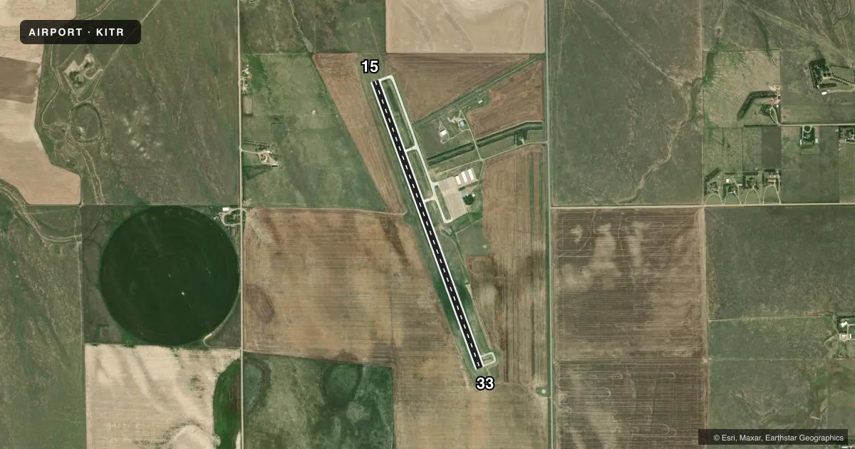
Airport sketch
Runways drawn to scale from FAA survey coordinates, rendered over satellite imagery. Not for navigation.
Approaches & charts
ILS · 1
Services on the field
Fuel grades, oxygen, maintenance, ramp storage and lighting — as declared to the FAA by the airport operator.
Fuel & services
- Fuel
- 100LLA1+
- Oxygen (bottled)
- Not available
- Oxygen (bulk)
- Not available
- Airframe repair
- Not available
- Power plant repair
- Not available
- Other services
- AGRI,INSTR
Ramp & ground
- Transient storage
- Tie-down
- Hangar
- Landing fee
- No fee published
- Lighting schedule
- SEE RMK
- Beacon schedule
- SS-SR
- Beacon
- White / Green (civil land)(WG)
- Wind indicator
- Lighted
- Segmented circle
- Yes
Fuel & FBOs
Cheapest 100LL and Jet A on the field and nearby. Always confirm with the FBO before taxi.
Airport notes
Surface conditions, obstructions, local procedures, lighting outages and other notes published with each FAA cycle.
General notes
- BE ALERT; INTENSIVE USAF STUDENT TRAINING IN VICINITY OF COLORADO SPRINGS & PUEBLO COLORADO.
- TXY MARKED WITH BLUE REFLECTORS.
- FOR CD CTC DENVER ARTCC AT 303-651-4257.
Lighting notes
- ACTVT MIRL RY 15/33; PAPI AND REIL RYS 15 & 33 - CTAF.
Fuel notes
- 100LL24 HR SELF SERVE FUEL AVBL.
VFR map & nearby airports
VFR sectional. Tap any ICAO chip to open that airport.
Key facts · KITR
Answer card- ICAO
- KITR
- Name
- KIT CARSON COUNTY
- Location
- BURLINGTON, COLORADO
- Elevation
- 4,218.4 ft MSL
- Traffic pattern altitude
- 5,218.4 ft MSL (1,000 AGL)
- Control tower
- Non-towered (use CTAF)
- Total runways
- 1
- Longest runway
- 15/33 · 5,199 ft
- Published ILS approaches
- 1
- Published frequencies
- 2
- Magnetic variation
- 6°
- Current flight rules
- VFR
- Current wind
- 350° at 8 kt
- Favored runway now
- RWY 33
Kit Carson County Airport (KITR) is in Burlington, Colorado. The field elevation is 4,218.4 ft MSL. It has one runway. Runway 15/33 is 5,199 ft long with an asphalt surface. The airport is non-towered. CTAF and UNICOM are both 122.8. The published pattern altitude is not listed, so use the standard 1,000 ft AGL for light piston traffic unless the current Chart Supplement says otherwise.
Runway 33 has an ILS approach. The runway lighting is medium intensity and the PAPI and REIL are available on both runway ends. Those lights are controlled by CTAF. Taxiways are marked with blue reflectors. The airport also notes 24-hour self-serve 100LL fuel. Kit Carson County Airport on the field carries AVGAS 100LL and Jet A. Call the airport at (719) 343-5630 for current details.
For a first-time arrival, plan for the elevation. Density altitude can run high here in warm weather. The airport also advises pilots to stay alert for intensive U.S. Air Force student training in the Colorado Springs and Pueblo area. If you need clearance delivery, contact Denver Air Route Traffic Control Center at 303-651-4257 before departure.