METAR & TAF 5K0
5K0 does not publish a METAR.
Showing the nearest reporting station: KSYF (CHEYENNE COUNTY MUNI) · 11.0 NM away. Conditions at 5K0 may differ.
METAR · KSYF
Observed 12:35Z
KSYF 271235Z AUTO 06007KT 10SM CLR 25/19 A2992 RMK AO2
- Wind
- 060° @ 7 kt
- Visibility
- 10 SM
- Temp / Dew
- 25°C / 19°C
- Altimeter
- 29.92 inHg
- Clouds
- CLR
- Density alt
- 5,526 ft
- Ceiling
- Unlimited
- Rules
- VFR
Airport info & contacts
Manager on record, flight service, ARTCC, attendance schedule and pattern altitude — published by the FAA and refreshed every 28 days.
Location
- From city
- 1 NM SW
- VFR sectional
- WICHITA
- ARTCC
- ZDV · DENVER
- NOTAM facility
- ICT (NOTAM-D)
Airport manager
- Name
- ROD YOUNG
- Phone
- 785-734-2631
- Address
- 122 WEST 6TH, BIRD CITY KS 67731
Flight service · Hours
- FSS ICT
- WICHITA1-800-WX-BRIEF
- Attendance
- APR-SEP · DALGT
- OCT-MAR · Unattended
Frequencies
Tap any row to copy the frequency to your clipboard.
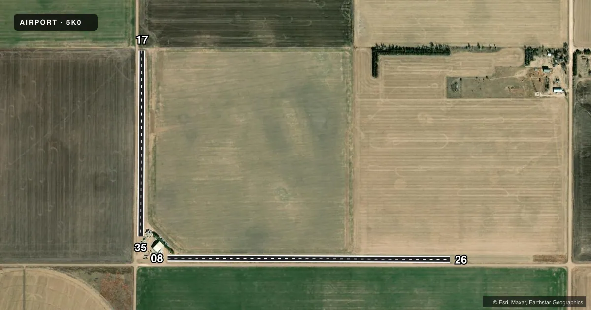
Runways & pattern
Full pagePattern entry · RWY 08
RIGHT TRAFFIC| Runway | Heading (°M) | Length | Surface | Traffic |
|---|---|---|---|---|
| 08/26Favored | 81° / 261° | 3,460 ft | TURF | 08 R |
| 17/35 | 171° / 351° | 2,270 ft | TURF | Standard L |
Runway end performance
| End | TORA | TODA | ASDA | LDA | VGSI | Approach lights | Obstruction |
|---|---|---|---|---|---|---|---|
| 08 | — | — | — | — | — | — | 17', road, 0' from thr, 65' R of cntrln, slope 1 |
| 26 | — | — | — | — | — | — | 18', road, 0' from thr, 65' R of cntrln, slope 1 |
| 17 | — | — | — | — | — | — | 17', road, 0' from thr, 77' R of cntrln, slope 1 |
| 35 | — | — | — | — | — | — | 17', road, 0' from thr, 77' R of cntrln, slope 1 |
Declared distances in feet. TORA = takeoff run available, TODA = takeoff distance, ASDA = accelerate-stop, LDA = landing distance.
Airport sketch
Runways drawn to scale from FAA survey coordinates, rendered over satellite imagery. Not for navigation.
Approaches & charts
Services on the field
Fuel grades, oxygen, maintenance, ramp storage and lighting — as declared to the FAA by the airport operator.
Fuel & services
- Fuel
- Not available
- Other services
- AGRI
Ramp & ground
- Transient storage
- Not published
- Wind indicator
- Yes
- Segmented circle
- No
Fuel & FBOs
Cheapest 100LL and Jet A on the field and nearby. Always confirm with the FBO before taxi.
Airport notes
Surface conditions, obstructions, local procedures, lighting outages and other notes published with each FAA cycle.
General notes
- FOR CD CTC DENVER ARTCC AT 303-651-4257.
Approach & departure obstructions
- 17NORTH END RWY MKD W/ORANGE & WHITE BARRELS.
Other notes
- PRVDD APCHS ARE MAINTAINED FOR A 20:1 GLIDE SLOPE & TRANSITIONAL SURFACE A 7:1 SLOPE; RGT HAND TFC PTN TO RWY 8 IS USED.
- 1OCT-MAR CALL 785-734-2631 FOR ARPT CONDS.
- 08/26EAST THIRD OF RWY ROUGH.
VFR map & nearby airports
VFR sectional. Tap any ICAO chip to open that airport.
Key facts · 5K0
Answer card- ICAO
- 5K0
- Name
- BRESSLER FLD
- Location
- BIRD CITY, KANSAS
- Elevation
- 3,489 ft MSL
- Traffic pattern altitude
- 4,489 ft MSL (1,000 AGL)
- Control tower
- Non-towered (use CTAF)
- Total runways
- 2
- Longest runway
- 08/26 · 3,460 ft
- Published ILS approaches
- 0
- Published frequencies
- 1
- Magnetic variation
- 9°
- Current flight rules
- VFR
- Current wind
- 060° at 7 kt
- Favored runway now
- RWY 08
Bressler Fld sits in Bird City, Kansas. The field elevation is 3,489 ft MSL. It has two turf runways. The longest is runway 08/26 at 3,460 ft. Runway 17/35 is 2,270 ft. There is no control tower. CTAF is 122.9.
No ILS approaches are published here. Pattern altitude is not published in the facts, so use the standard 1,000 ft AGL for light piston operations unless the current Chart Supplement says otherwise. The airport sits in western Kansas, so density altitude can be a factor on warm days. That matters on turf, especially with the elevation and the shorter runway. The published remarks also call out rough turf on the east third of runway 08/26. The north end of runway 17 is marked with orange and white barrels. Right-hand traffic is used for runway 8.
There are no on-field FBOs listed in the facts. Plan on confirming services with the airport operator or the FBO directly by phone before arrival. From October through March, call 785-734-2631 for airport conditions. For clearance delivery, contact Denver ARTCC at 303-651-4257.