METAR & TAF KADT
Current METAR
Observed 13:10Z
KADT 271310Z AUTO 03013KT 10SM CLR 28/20 A2993 RMK AO2 T02840198
- Wind
- 030° @ 13 kt
- Visibility
- 10 SM
- Temp / Dew
- 28°C / 20°C
- Altimeter
- 29.93 inHg
- Clouds
- CLR
- Density alt
- 5,256 ft
- Ceiling
- Unlimited
- Rules
- VFR
Airport info & contacts
Manager on record, flight service, ARTCC, attendance schedule and pattern altitude — published by the FAA and refreshed every 28 days.
Location
- From city
- 2 NM N
- VFR sectional
- WICHITA
- ARTCC
- ZDV · DENVER
- NOTAM facility
- ICT (NOTAM-D)
Airport manager
- Name
- KEVIN WORTHY
- Phone
- 785-626-3344
- Address
- 12323 HWY 25, ATWOOD KS 67730
Flight service · Hours
- FSS ICT
- WICHITA1-800-WX-BRIEF
- Attendance
- Unattended
Frequencies
Tap any row to copy the frequency to your clipboard.
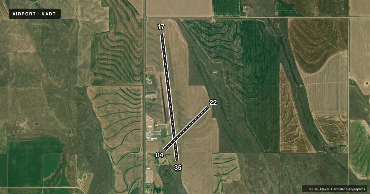
Runways & pattern
Full pagePattern entry · RWY 04
LEFT TRAFFIC| Runway | Heading (°M) | Length | Surface | Traffic |
|---|---|---|---|---|
| 17/35 | 167° / 347° | 5,000 ft | ASPH | Standard L |
| 04/22Favored | 40° / 220° | 2,400 ft | TURF | Standard L |
Runway end performance
| End | TORA | TODA | ASDA | LDA | VGSI | Approach lights | Obstruction |
|---|---|---|---|---|---|---|---|
| 17 | — | — | — | — | PAPI 2-box left(3°) | — | — |
| 35 | — | — | — | — | PAPI 2-box right(3°) | — | — |
| 04 | — | — | — | — | — | — | 28', pline, 950' from thr, 0' R of cntrln, slope 33 |
Declared distances in feet. TORA = takeoff run available, TODA = takeoff distance, ASDA = accelerate-stop, LDA = landing distance.
Airport sketch
Runways drawn to scale from FAA survey coordinates, rendered over satellite imagery. Not for navigation.
Approaches & charts
Services on the field
Fuel grades, oxygen, maintenance, ramp storage and lighting — as declared to the FAA by the airport operator.
Fuel & services
- Fuel
- 100LL
- Oxygen (bottled)
- Not available
- Oxygen (bulk)
- Not available
- Other services
- AGRI
Ramp & ground
- Transient storage
- Tie-down
- Hangar
- Landing fee
- No fee published
- Lighting schedule
- SEE RMK
- Beacon schedule
- SS-SR
- Beacon
- White / Green (civil land)(WG)
- Wind indicator
- Lighted
- Segmented circle
- Yes
Fuel & FBOs
Cheapest 100LL and Jet A on the field and nearby. Always confirm with the FBO before taxi.
Airport notes
Surface conditions, obstructions, local procedures, lighting outages and other notes published with each FAA cycle.
General notes
- PUBLIC PHONE AVBL 24 HRS.
- FOR CD CTC DENVER ARTCC AT 303-651-4257.
Lighting notes
- ACTVT REIL RWY 17 & 35; PAPI RWYS RWY 17 & 35; MIRL RWY 17/35 - CTAF.
Fuel notes
- 100LL24 HR SELF-SERVE FUEL.
Other notes
- EXISTED PRIOR TO 1959.
- 04/22ACUTE DIFFERENCE IN SFC ELEV AT INT WITH RWY 17 & 35. SUG OPS BE CONDUCTED E OF THAT INT.
VFR map & nearby airports
VFR sectional. Tap any ICAO chip to open that airport.
Key facts · KADT
Answer card- ICAO
- KADT
- Name
- ATWOOD/RAWLINS COUNTY
- Location
- ATWOOD, KANSAS
- Elevation
- 2,990.7 ft MSL
- Traffic pattern altitude
- 3,990.7 ft MSL (1,000 AGL)
- Control tower
- Non-towered (use CTAF)
- Total runways
- 2
- Longest runway
- 17/35 · 5,000 ft
- Published ILS approaches
- 0
- Published frequencies
- 2
- Magnetic variation
- 6°
- Current flight rules
- VFR
- Current wind
- 030° at 13 kt
- Favored runway now
- RWY 04
Atwood/Rawlins County Airport (KADT) sits in Atwood, Kansas. Field elevation is 2,990.7 ft MSL. The airport has two runways. The longest is 17/35 at 5,000 ft asphalt. Runway 04/22 is 2,400 ft turf. There is no control tower. CTAF and UNICOM are both 122.7.
No ILS approaches are published here. Pattern altitude is not published, so use the current FAA Chart Supplement before you go. The airport has 24-hour self-serve 100LL. The on-field FBO is Atwood-Rawlins County Airport. It carries AVGAS 100LL. Call (785) 626-9014 for current service details.
Runway 17/35 has medium intensity lighting controlled by CTAF. Runway end identifier lights and PAPI are installed on 17 and 35. For clearance delivery, contact Denver ARTCC at 303-651-4257. One operational note matters on the turf side. There is an acute elevation change where runway 04/22 meets 17/35. Suggested operations are east of that intersection. If you are new to the field, plan for the higher elevation and check density altitude before departure. This is a non-towered airport, so standard self-announce discipline matters on 122.7.