METAR & TAF KGLD
Current METAR
Observed 02:53Z
KGLD 270253Z AUTO 13006KT 10SM CLR 29/14 A2988 RMK AO2 SLP058 T02890144 53003
- Wind
- 130° @ 6 kt
- Visibility
- 10 SM
- Temp / Dew
- 29°C / 14°C
- Altimeter
- 29.88 inHg
- Clouds
- CLR
- Density alt
- 6,265 ft
- Ceiling
- Unlimited
- Rules
- VFR
Airport info & contacts
Manager on record, flight service, ARTCC, attendance schedule and pattern altitude — published by the FAA and refreshed every 28 days.
Location
- From city
- 2 NM N
- VFR sectional
- WICHITA
- ARTCC
- ZDV · DENVER
- NOTAM facility
- GLD (NOTAM-D)
Airport manager
- Name
- KENT BROWN
- Phone
- 785-890-4501
- Address
- 204 W. 11TH ST., GOODLAND KS 67735
Flight service · Hours
- FSS ICT
- WICHITA1-800-WX-BRIEF
- Attendance
- DALGT
Frequencies
Tap any row to copy the frequency to your clipboard.
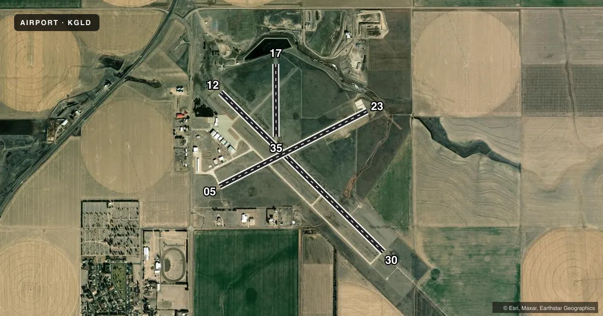
Runways & pattern
Full pagePattern entry · RWY 12
LEFT TRAFFIC| Runway | Heading (°M) | Length | Surface | Traffic |
|---|---|---|---|---|
| 12/30Favored | 125° / 305° | 5,499 ft | CONC | Standard L |
| 05/23 | 54° / 234° | 4,001 ft | CONC | Standard L |
| 17/35 | 171° / 351° | 1,754 ft | TURF | Standard L |
Runway end performance
| End | TORA | TODA | ASDA | LDA | VGSI | Approach lights | Obstruction |
|---|---|---|---|---|---|---|---|
| 12 | — | — | — | — | — | — | 30', bldg, 720' from thr, 525' R of cntrln, slope 17 |
| 30 | — | — | — | — | — | MALSR | — |
| 05 | — | — | — | — | PAPI 4-box left(3°) | — | 22', road, 625' from thr, 270' R of cntrln, slope 19 |
| 23 | — | — | — | — | PAPI 4-box left(3°) | — | — |
| 17 | — | — | — | — | — | — | 62', pole, 378' from thr, 0' R of cntrln, slope 6 |
Declared distances in feet. TORA = takeoff run available, TODA = takeoff distance, ASDA = accelerate-stop, LDA = landing distance.
Airport sketch
Runways drawn to scale from FAA survey coordinates, rendered over satellite imagery. Not for navigation.
Approaches & charts
ILS · 1
Services on the field
Fuel grades, oxygen, maintenance, ramp storage and lighting — as declared to the FAA by the airport operator.
Fuel & services
- Fuel
- 100LLA+
- Oxygen (bottled)
- Not available
- Oxygen (bulk)
- Low pressure
- Airframe repair
- Major
- Power plant repair
- Major
- Other services
- AGRI,INSTR,RNTL
Ramp & ground
- Transient storage
- Tie-down
- Hangar
- Landing fee
- No fee published
- Customs
- Not available
- Lighting schedule
- SEE RMK
- Beacon schedule
- SS-SR
- Beacon
- White / Green (civil land)(WG)
- Wind indicator
- Lighted
- Segmented circle
- No
Fuel & FBOs
Cheapest 100LL and Jet A on the field and nearby. Always confirm with the FBO before taxi.
Airport notes
Surface conditions, obstructions, local procedures, lighting outages and other notes published with each FAA cycle.
General notes
- TWY A2 ONLY AVBL FOR ACFT OVER 12500 LBS.
- FOR CD CTC DENVER ARTCC ON FREQ. IF UNA, CTC FSS ON FREQ VIA RCO. IF UNA, CTC DENVER ARTCC AT 303-651-4257.
Lighting notes
- ACTVT MALSR RWY 30; REIL RWY 12; PAPI RWY 05 & 23; MIRL RWY 05/23 & 12/30 - CTAF.
Approach & departure obstructions
- 23TURN-AROUND DOES NOT HAVE CLNC FOR HLDG.
- 30CALM WIND RWY.
- 173 FT DIA YELLOW CONES MARK THLD.
- 353 FT DIA YELLOW CONES MARK THLD.
- 05PAPI UNUSBL BYD 8 DEGS L OF CNTRLN.
- 17UNMKD 30 FT PLINE, 1300 FT DSTC, ACRS APCH, 43:1.
Other notes
- 1FOR SVC CALL 785-890-7531 (DAY) OR 785-443-1328 (NIGHT).
- MANAGERCITY/ARPT MGR.
VFR map & nearby airports
VFR sectional. Tap any ICAO chip to open that airport.
Key facts · KGLD
Answer card- ICAO
- KGLD
- Name
- RENNER FLD/GOODLAND MUNI
- Location
- GOODLAND, KANSAS
- Elevation
- 3,657.6 ft MSL
- Traffic pattern altitude
- 4,657.6 ft MSL (1,000 AGL)
- Control tower
- Non-towered (use CTAF)
- Total runways
- 3
- Longest runway
- 12/30 · 5,499 ft
- Published ILS approaches
- 1
- Published frequencies
- 2
- Magnetic variation
- 9°
- Current flight rules
- VFR
- Current wind
- 130° at 6 kt
- Favored runway now
- RWY 12
Renner Fld/Goodland Muni sits in Goodland, Kansas. Field elevation is 3,657.6 ft MSL. The airport has three runways. The longest is runway 12/30 at 5,499 ft. There is no control tower. CTAF and UNICOM are both 122.8.
The airport has one ILS approach to runway 30. Pattern altitude is not published in the facts, so a light piston pilot should plan on the standard 1,000 ft AGL unless the current Chart Supplement says otherwise. Butterfly Aviation is on the field. It carries 100LL and Jet A Prist. Call them at (785) 890-7531 for current service details.
Several published remarks matter for planning. Runway 30 is listed as the calm wind runway. MALSR is activated for runway 30. Runway end identifier lights are installed on runway 12. PAPI is installed on runways 05 and 23. The PAPI on runway 05 is unusable beyond 8 degrees left of centerline. There is also an unmarked 30-foot power line 1,300 feet out on the runway 17 approach. Taxiway A2 is only available for aircraft over 12,500 pounds. This is high-plains flying at 3,657.6 ft MSL, so expect density altitude to matter on warm days. Check the current Chart Supplement for any published noise or curfew restrictions before flying in.