METAR & TAF KLAR
Current METAR
Observed 15:53Z
KLAR 271553Z AUTO 16009KT 10SM OVC100 23/11 A3032 RMK AO2 SLP138 T02280106
- Wind
- 160° @ 9 kt
- Visibility
- 10 SM
- Temp / Dew
- 23°C / 11°C
- Altimeter
- 30.32 inHg
- Clouds
- OVC
- Density alt
- 9,496 ft
- Ceiling
- 10,000 ft AGL
- Rules
- VFR
Airport info & contacts
Manager on record, flight service, ARTCC, attendance schedule and pattern altitude — published by the FAA and refreshed every 28 days.
Location
- From city
- 3 NM W
- VFR sectional
- CHEYENNE
- ARTCC
- ZDV · DENVER
- NOTAM facility
- LAR (NOTAM-D)
Airport manager
- Name
- AMY TERRELL
- Phone
- 307-742-4164
- Address
- 555 GENERAL BREES RD, LARAMIE WY 82070
Flight service · Hours
- FSS CPR
- CASPER1-800-WX-BRIEF
- Attendance
- OCT - APR · 0600-1900
- MAY-SEPT · 0700-1900
Frequencies
Tap any row to copy the frequency to your clipboard.
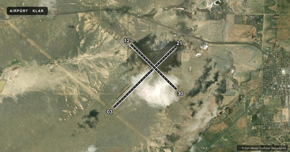
Runways & pattern
Full pagePattern entry · RWY 12
LEFT TRAFFIC| Runway | Heading (°M) | Length | Surface | Traffic |
|---|---|---|---|---|
| 03/21 | 33° / 213° | 8,503 ft | ASPH | Standard L |
| 12/30Favored | 122° / 302° | 6,301 ft | ASPH | Standard L |
Runway end performance
| End | TORA | TODA | ASDA | LDA | VGSI | Approach lights | Obstruction |
|---|---|---|---|---|---|---|---|
| 03 | 8,503' | 8,503' | 8,503' | 8,503' | PAPI 4-box left(3°) | — | — |
| 21 | 8,503' | 8,503' | 8,503' | 8,503' | PAPI 4-box left(3°) | — | — |
| 12 | 6,301' | 6,301' | 6,301' | 6,301' | PAPI 4-box left(3°) | — | — |
| 30 | 6,301' | 6,301' | 6,301' | 6,301' | PAPI 4-box left(3°) | ODALS | — |
Declared distances in feet. TORA = takeoff run available, TODA = takeoff distance, ASDA = accelerate-stop, LDA = landing distance.
Airport sketch
Runways drawn to scale from FAA survey coordinates, rendered over satellite imagery. Not for navigation.
Approaches & charts
Services on the field
Fuel grades, oxygen, maintenance, ramp storage and lighting — as declared to the FAA by the airport operator.
Fuel & services
- Fuel
- 100LLA
- Oxygen (bottled)
- Not available
- Oxygen (bulk)
- Not available
- Airframe repair
- Not available
- Power plant repair
- Not available
- Other services
- AFRT,CHTR,INSTR,RNTL
Ramp & ground
- Transient storage
- Tie-down
- Hangar
- Landing fee
- Yes
- Customs
- Not available
- Lighting schedule
- SEE RMK
- Beacon schedule
- SS-SR
- Beacon
- White / Green (civil land)(WG)
- Wind indicator
- Lighted
- Segmented circle
- Yes
Fuel & FBOs
Cheapest 100LL and Jet A on the field and nearby. Always confirm with the FBO before taxi.
Airport notes
Surface conditions, obstructions, local procedures, lighting outages and other notes published with each FAA cycle.
General notes
- AFLD SFC COND UNMNTD 2200-0500.
- FOR CD CTC DENVER ARTCC ON FREQ. IF UNA, CTC FSS ON FREQ VIA RCO. IF UNA, CTC DENVER ARTCC AT 303-651-4257.
Lighting notes
- ACTVT ODALS RWY 30; REIL RWY 03, 21 & 12; PAPI RWY 03, 12, 21, & 30; MIRL RWY 03/21 & RWY 12/30 - CTAF.
Runway surface & condition
- 03/21PCR VALUE: 320/F/C/X/T
- 12/30PCR VALUE: 350/F/C/X/T
Other notes
- INDEX B AVBL UPON REQ.
VFR map & nearby airports
VFR sectional. Tap any ICAO chip to open that airport.
Key facts · KLAR
Answer card- ICAO
- KLAR
- Name
- LARAMIE RGNL
- Location
- LARAMIE, WYOMING
- Elevation
- 7,283.7 ft MSL
- Traffic pattern altitude
- 8,283.7 ft MSL (1,000 AGL)
- Control tower
- Non-towered (use CTAF)
- Total runways
- 2
- Longest runway
- 03/21 · 8,503 ft
- Published ILS approaches
- 0
- Published frequencies
- 2
- Magnetic variation
- 13°
- Current flight rules
- VFR
- Current wind
- 160° at 9 kt
- Favored runway now
- RWY 12
Laramie Rgnl sits in Laramie, Wyoming at 7,283.7 ft MSL. It has two asphalt runways. The longest is 8,503 ft on runway 03/21. Runway 12/30 is 6,301 ft. There is no control tower, so use CTAF 123.05 for self-announce traffic. No ILS approaches are published here. Pattern altitude is not published. Use the standard 1,000 ft AGL for light piston ops unless the current Chart Supplement says otherwise.
Cowboy Aviation is on the field. It carries 100LL and Jet A Prist. For a first-time arrival, the big item is altitude. Performance will feel different here, especially on warm days. The field also sits in Wyoming terrain, so plan your climb and descent with the elevation in mind. Published remarks note that runway 30 has an omnidirectional approach lighting system. PAPI is installed on all four runway ends. Runway end identifier lights are installed on 03, 12 and 21. Airport surface condition is unmonitored from 2200 to 0500. Check conditions before a night arrival. Clearance delivery is handled through Denver Center or Flight Service when needed.