METAR & TAF KDGW
Current METAR
Observed 12:53Z
KDGW 271253Z AUTO 14010KT 10SM CLR 24/12 A3008 RMK AO2 SLP102 T02390117
- Wind
- 140° @ 10 kt
- Visibility
- 10 SM
- Temp / Dew
- 24°C / 12°C
- Altimeter
- 30.08 inHg
- Clouds
- CLR
- Density alt
- 6,998 ft
- Ceiling
- Unlimited
- Rules
- VFR
Airport info & contacts
Manager on record, flight service, ARTCC, attendance schedule and pattern altitude — published by the FAA and refreshed every 28 days.
Location
- From city
- 3 NM N
- VFR sectional
- CHEYENNE
- ARTCC
- ZDV · DENVER
- NOTAM facility
- DGW (NOTAM-D)
Airport manager
- Name
- STEVE GOOD
- Phone
- 307-358-4924
- Address
- P O BOX 774, DOUGLAS WY 82633
Flight service · Hours
- FSS CPR
- CASPER1-800-WX-BRIEF
- Attendance
- MON-FRI · 0630-1700
- SAT-SUN · 0800-1700
Frequencies
Tap any row to copy the frequency to your clipboard.
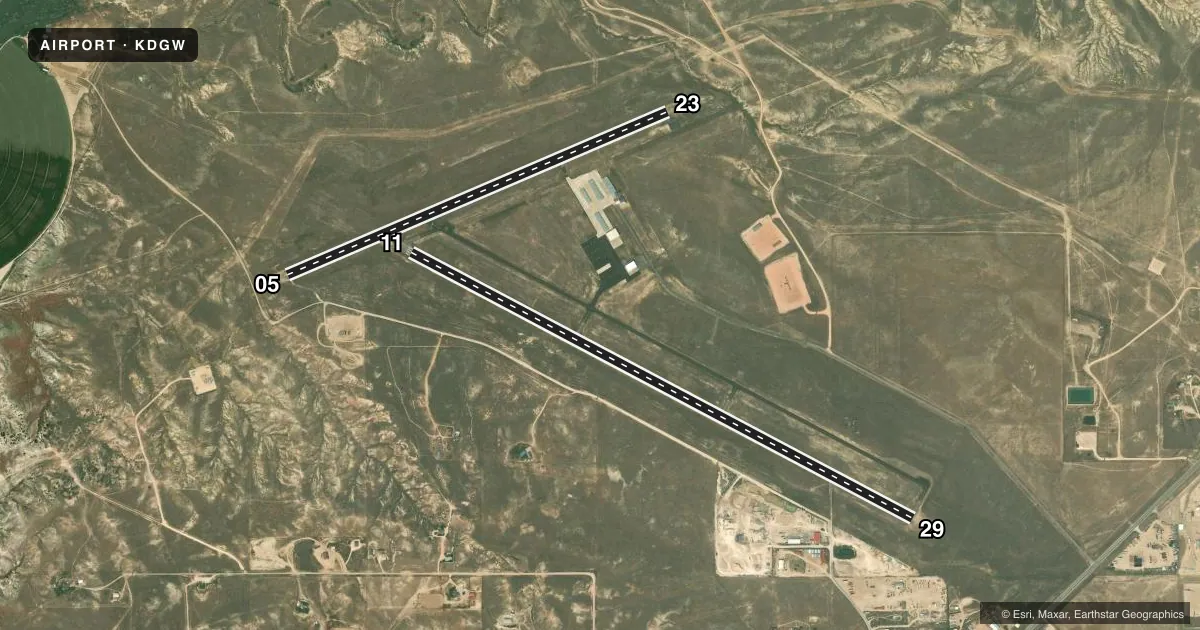
Runways & pattern
Full pagePattern entry · RWY 11
LEFT TRAFFIC| Runway | Heading (°M) | Length | Surface | Traffic |
|---|---|---|---|---|
| 11/29Favored | 107° / 287° | 6,534 ft | ASPH | Standard L |
| 05/23 | 56° / 236° | 4,760 ft | GRVL-DIRT | Standard L |
Runway end performance
| End | TORA | TODA | ASDA | LDA | VGSI | Approach lights | Obstruction |
|---|---|---|---|---|---|---|---|
| 11 | — | — | — | — | PAPI 2-box left(3°) | — | — |
| 29 | — | — | — | — | PAPI 2-box left(3°) | — | — |
| 23 | — | — | — | — | PAPI 2-box left(3°) | — | 116', hill, 2925' from thr, 175' R of cntrln, slope 23 |
Declared distances in feet. TORA = takeoff run available, TODA = takeoff distance, ASDA = accelerate-stop, LDA = landing distance.
Airport sketch
Runways drawn to scale from FAA survey coordinates, rendered over satellite imagery. Not for navigation.
Approaches & charts
Services on the field
Fuel grades, oxygen, maintenance, ramp storage and lighting — as declared to the FAA by the airport operator.
Fuel & services
- Fuel
- 100LLA
- Oxygen (bottled)
- Not available
- Oxygen (bulk)
- Not available
- Airframe repair
- Major
- Power plant repair
- Major
Ramp & ground
- Transient storage
- Tie-down
- Hangar
- Landing fee
- No fee published
- Lighting schedule
- SEE RMK
- Beacon schedule
- SS-SR
- Beacon
- White / Green (civil land)(WG)
- Wind indicator
- Lighted
- Segmented circle
- Yes
Fuel & FBOs
Cheapest 100LL and Jet A on the field and nearby. Always confirm with the FBO before taxi.
Airport notes
Surface conditions, obstructions, local procedures, lighting outages and other notes published with each FAA cycle.
General notes
- WILDLIFE ON & INVOF ARPT.
- RETRO-REFLECTIVE MKRS ALG ALL TWYS.
- FOR CD IF UNA TO CTC ON FSS FREQ, CTC DENVER ARTCC AT 303-651-4257.
Lighting notes
- ACTVT REIL RWYS 11 AND 29; MIRL RWY 05/23 &11/29 DALGT HRS - 122.8. MIRL RWY 05/23 & 11/29 PRESET TO LOW INTST DARK HRS, TO INCR INTST - 122.8. PAPI RWY 11, 23 & 29 OPR CONSLY.
Fuel notes
- 100LLFUEL AFT HRS SEE PHONE NRS POSTED IN TRML LOBBY. CALL OUT FEE WILL APPLY.
Other notes
- 05/23ASPH REMOVED & CONVERTED TO A TREATED BASE SFC 2019.
VFR map & nearby airports
VFR sectional. Tap any ICAO chip to open that airport.
Key facts · KDGW
Answer card- ICAO
- KDGW
- Name
- CONVERSE COUNTY
- Location
- DOUGLAS, WYOMING
- Elevation
- 4,932.7 ft MSL
- Traffic pattern altitude
- 5,932.7 ft MSL (1,000 AGL)
- Control tower
- Non-towered (use CTAF)
- Total runways
- 2
- Longest runway
- 11/29 · 6,534 ft
- Published ILS approaches
- 0
- Published frequencies
- 2
- Magnetic variation
- 11°
- Current flight rules
- VFR
- Current wind
- 140° at 10 kt
- Favored runway now
- RWY 11
Converse County Airport sits near Douglas, Wyoming. Field elevation is 4,932.7 ft MSL. This is a two-runway field with the longest runway at 6,534 ft. There is no control tower. CTAF and UNICOM are both 122.8. No ILS approaches are published here.
Runway 11/29 is the longest runway. It is asphalt. Runway 05/23 is 4,760 ft and is listed as gravel-dirt. The published pattern altitude is not given, so use the standard 1,000 ft AGL pattern unless the current Chart Supplement says otherwise. That puts the light piston pattern at 5,932.7 ft MSL based on the field elevation.
R&G Aircraft Service is on the field. Fuel grades are not reported in the facts, so confirm what is available with the FBO before you go. The published remarks also note after-hours 100LL fuel with a call-out fee. Lighting is worth planning for here. Runway end identifier lights are active on 11 and 29. Medium intensity runway lights serve both runways. They are preset low during dark hours. Use 122.8 to brighten them. Wildlife is reported on and near the airport, so expect a careful scan on taxi, takeoff and landing. Retro-reflective taxiway markers are installed. If you need clearance delivery and cannot reach Flight Service, contact Denver ARTCC at 303-651-4257.