METAR & TAF KLSK
KLSK does not publish a METAR.
Showing the nearest reporting station: KGUR (CAMP GUERNSEY) · 32.9 NM away. Conditions at KLSK may differ.
METAR · KGUR
Observed 15:55Z
KGUR 241555Z AUTO 00000KT 10SM CLR 28/18 A3011 RMK AO2 SLP164 T02760180
- Wind
- 000° @ 0 kt
- Visibility
- 10 SM
- Temp / Dew
- 28°C / 18°C
- Altimeter
- 30.11 inHg
- Clouds
- CLR
- Density alt
- 7,483 ft
- Ceiling
- Unlimited
- Rules
- VFR
Airport info & contacts
Manager on record, flight service, ARTCC, attendance schedule and pattern altitude — published by the FAA and refreshed every 28 days.
Location
- From city
- 3 NM E
- VFR sectional
- CHEYENNE
- ARTCC
- ZDV · DENVER
- NOTAM facility
- CPR (NOTAM-D)
Airport manager
- Name
- ROYCE THOMPSON
- Phone
- 307-334-3622
- Address
- BOX 390, LUSK WY 82225
Flight service · Hours
- FSS CPR
- CASPER1-800-WX-BRIEF
- Attendance
- Unattended
Frequencies
Tap any row to copy the frequency to your clipboard.
Runways & pattern
Full pagePattern entry · RWY 10
LEFT TRAFFICRunway end performance
| End | TORA | TODA | ASDA | LDA | VGSI | Approach lights | Obstruction |
|---|---|---|---|---|---|---|---|
| 10 | — | — | — | — | PAPI 2-box left(3°) | — | 5', pole, 268' from thr, 48' R of cntrln, slope 13 |
| 28 | — | — | — | — | PAPI 2-box left(3°) | — | — |
Declared distances in feet. TORA = takeoff run available, TODA = takeoff distance, ASDA = accelerate-stop, LDA = landing distance.
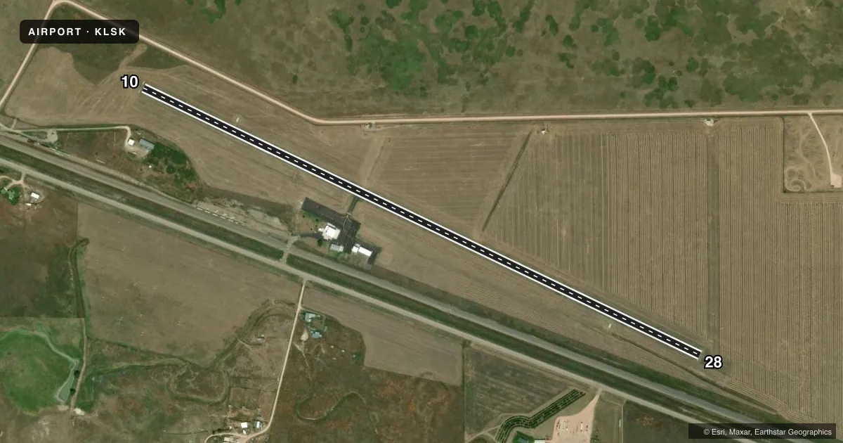
Airport sketch
Runways drawn to scale from FAA survey coordinates, rendered over satellite imagery. Not for navigation.
Approaches & charts
Services on the field
Fuel grades, oxygen, maintenance, ramp storage and lighting — as declared to the FAA by the airport operator.
Fuel & services
- Fuel
- 100LL
- Oxygen (bottled)
- Not available
- Oxygen (bulk)
- Not available
- Airframe repair
- Not available
- Power plant repair
- Not available
Ramp & ground
- Transient storage
- Tie-down
- Landing fee
- No fee published
- Customs
- Not available
- Lighting schedule
- SEE RMK
- Beacon schedule
- SS-SR
- Beacon
- White / Green (civil land)(WG)
- Wind indicator
- Lighted
- Segmented circle
- No
Fuel & FBOs
Cheapest 100LL and Jet A on the field and nearby. Always confirm with the FBO before taxi.
Airport notes
Surface conditions, obstructions, local procedures, lighting outages and other notes published with each FAA cycle.
General notes
- FOR CD IF UNA TO CTC ON FSS FREQ, CTC DENVER ARTCC AT 303-651-4257.
Lighting notes
- ACTVT REIL RWY 28; PAPI RWY 10 & 28; MIRL RWY 10/28 - 122.8.
Fuel notes
- 100LLAVBL VIA CREDIT CARD READER.
VFR map & nearby airports
VFR sectional. Tap any ICAO chip to open that airport.
Key facts · KLSK
Answer card- ICAO
- KLSK
- Name
- LUSK MUNI
- Location
- LUSK, WYOMING
- Elevation
- 4,966.8 ft MSL
- Traffic pattern altitude
- 5,966.8 ft MSL (1,000 AGL)
- Control tower
- Non-towered (use CTAF)
- Total runways
- 1
- Longest runway
- 10/28 · 5,058 ft
- Published ILS approaches
- 0
- Published frequencies
- 2
- Magnetic variation
- 12°
- Current flight rules
- VFR
- Current wind
- 000° at 0 kt
- Favored runway now
- –
Lusk Muni sits in Lusk, Wyoming. The field elevation is 4,966.8 ft MSL. It has one runway. Runway 10/28 is 5,058 ft long with an asphalt surface. There is no control tower. CTAF and UNICOM are both 122.8. No ILS approaches are published here.
The pattern altitude is not published. Use the standard 1,000 ft AGL for light piston traffic unless the current Chart Supplement says otherwise. The on-field FBO is Lusk Municipal Airport. It carries AVGAS 100LL. Fuel is available via credit card reader. The field also has runway end identifier lights on Runway 28. Runways 10 and 28 have precision approach path indicators. Runways 10 and 28 also have medium intensity runway lights.
This is a high-elevation airport, so performance planning matters. Expect thinner air than you get at lower fields. Check takeoff and landing numbers with your aircraft and weight. If you need clearance delivery and cannot reach Flight Service on the published frequency, the Chart Supplement says to contact Denver ARTCC at 303-651-4257. For any current noise, airspace, or operating changes, verify with the current FAA Chart Supplement or the airport operator before you go.