METAR & TAF KTOR
Current METAR
Observed 11:53Z
KTOR 271153Z AUTO 31004KT 10SM CLR 23/13 A3004 RMK AO2 SLP107 70003 T02280133 10267 20211 53008 $
- Wind
- 310° @ 4 kt
- Visibility
- 10 SM
- Temp / Dew
- 23°C / 13°C
- Altimeter
- 30.04 inHg
- Clouds
- CLR
- Density alt
- 6,028 ft
- Ceiling
- Unlimited
- Rules
- VFR
Airport info & contacts
Manager on record, flight service, ARTCC, attendance schedule and pattern altitude — published by the FAA and refreshed every 28 days.
Location
- From city
- 2 NM E
- VFR sectional
- CHEYENNE
- ARTCC
- ZDV · DENVER
- NOTAM facility
- TOR (NOTAM-D)
Airport manager
- Name
- MIKE RICHEY
- Phone
- 307-532-8551
- Address
- 2000 E 20TH AVE., TORRINGTON WY 82240
Flight service · Hours
- FSS CPR
- CASPER1-800-WX-BRIEF
- Attendance
- 0800-1700
Frequencies
Tap any row to copy the frequency to your clipboard.
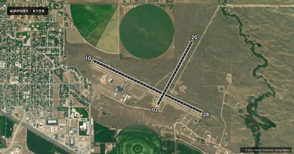
Runways & pattern
Full pagePattern entry · RWY 28
LEFT TRAFFIC| Runway | Heading (°M) | Length | Surface | Traffic |
|---|---|---|---|---|
| 10/28Favored | 108° / 288° | 5,703 ft | ASPH | Standard L |
| 02/20 | 22° / 202° | 3,401 ft | ASPH | 02 R |
Runway end performance
| End | TORA | TODA | ASDA | LDA | VGSI | Approach lights | Obstruction |
|---|---|---|---|---|---|---|---|
| 10 | — | — | — | — | PAPI 2-box left(3°) | — | — |
| 28 | — | — | — | — | PAPI 2-box left(3°) | — | 13', hill, 666' from thr, 53' R of cntrln, slope 35 |
Declared distances in feet. TORA = takeoff run available, TODA = takeoff distance, ASDA = accelerate-stop, LDA = landing distance.
Airport sketch
Runways drawn to scale from FAA survey coordinates, rendered over satellite imagery. Not for navigation.
Approaches & charts
Services on the field
Fuel grades, oxygen, maintenance, ramp storage and lighting — as declared to the FAA by the airport operator.
Fuel & services
- Fuel
- 100LLA+
- Oxygen (bottled)
- Not available
- Oxygen (bulk)
- Not available
- Airframe repair
- Major
- Power plant repair
- Not available
- Other services
- AGRI,INSTR
Ramp & ground
- Transient storage
- Tie-down
- Hangar
- Landing fee
- No fee published
- Customs
- Not available
- Lighting schedule
- SEE RMK
- Beacon schedule
- SS-SR
- Beacon
- White / Green (civil land)(WG)
- Wind indicator
- Lighted
- Segmented circle
- Yes
Fuel & FBOs
Cheapest 100LL and Jet A on the field and nearby. Always confirm with the FBO before taxi.
Airport notes
Surface conditions, obstructions, local procedures, lighting outages and other notes published with each FAA cycle.
General notes
- DEER & WATERFOWL ON & INVOF ARPT.
- FOR CD CTC DENVER ARTCC AT 303-651-4257.
Lighting notes
- ACTVT REIL RWY 28; PAPI RWY 10 & 28; MIRL RWY 10/28 - CTAF.
Fuel notes
- 100LLFOR FUEL AFT HRS CALL 307-338-8835.
Approach & departure obstructions
- 28REIL OTS INDEFLY.
Other notes
- EXISTED PRIOR TO 1959.
- 1EXC NTL HOLS.
VFR map & nearby airports
VFR sectional. Tap any ICAO chip to open that airport.
Key facts · KTOR
Answer card- ICAO
- KTOR
- Name
- TORRINGTON MUNI
- Location
- TORRINGTON, WYOMING
- Elevation
- 4,206.9 ft MSL
- Traffic pattern altitude
- 5,206.9 ft MSL (1,000 AGL)
- Control tower
- Non-towered (use CTAF)
- Total runways
- 2
- Longest runway
- 10/28 · 5,703 ft
- Published ILS approaches
- 0
- Published frequencies
- 2
- Magnetic variation
- 7°
- Current flight rules
- VFR
- Current wind
- 310° at 4 kt
- Favored runway now
- RWY 28
Torrington Muni sits in Torrington, Wyoming at 4,206.9 ft MSL. It has two asphalt runways. The longest is 5,703 ft on runway 10/28. There is no control tower. CTAF and UNICOM are both 122.8. No ILS approaches are published here. Pattern altitude is not published, so a light piston pilot should plan on the standard 1,000 ft AGL unless the current Chart Supplement says otherwise.
The on-field FBO is Torrington Municipal Airport. It carries 100LL and Jet A. Airport attendance is available daily except national holidays. For fuel after hours, the published remarks give a phone number to call. Runway 10 and 28 have medium intensity lights. PAPI is installed on both of those runways. Runway end identifier lights are listed for runway 28. They are out of service indefinitely.
This is a non-towered field, so use the common traffic advisory frequency and make your calls early. Deer and waterfowl are reported on and near the airport. That matters on taxi, takeoff and landing. The field is in Wyoming at a fairly high elevation, so performance planning should be part of the brief. Check the current FAA Chart Supplement for any updated remarks before you go.