METAR & TAF 13R
13R does not publish a METAR.
Showing the nearest reporting station: KEEO (MEEKER COULTER FLD) · 38.0 NM away. Conditions at 13R may differ.
METAR · KEEO
Observed 00:53Z
KEEO 270053Z AUTO 11007KT 10SM CLR 28/11 A3021 RMK AO2 SLP129 T02830106
- Wind
- 110° @ 7 kt
- Visibility
- 10 SM
- Temp / Dew
- 28°C / 11°C
- Altimeter
- 30.21 inHg
- Clouds
- CLR
- Density alt
- 7,808 ft
- Ceiling
- Unlimited
- Rules
- VFR
Airport info & contacts
Manager on record, flight service, ARTCC, attendance schedule and pattern altitude — published by the FAA and refreshed every 28 days.
Location
- From city
- 5 NM NE
- VFR sectional
- CHEYENNE
- ARTCC
- ZDV · DENVER
- NOTAM facility
- DEN
Airport manager
- Name
- RIO BLANCO WATER CONSERVANCE DIS.
- Phone
- 970-675-5055
- Address
- 2252 E MAIN ST, RANGELY CO 81648
Flight service · Hours
- FSS DEN
- DENVER1-800-WX-BRIEF
Frequencies
Tap any row to copy the frequency to your clipboard.
Runways & pattern
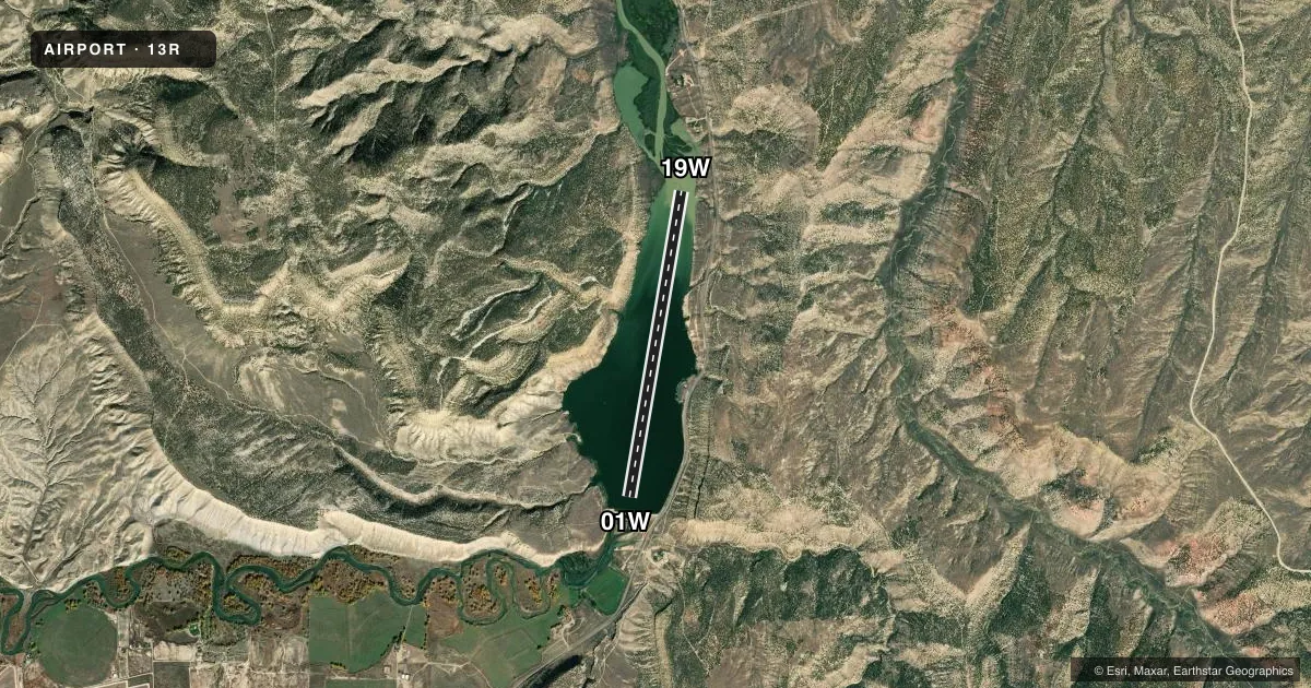
Full pagePattern entry · RWY 19W
LEFT TRAFFICAirport sketch
Runways drawn to scale from FAA survey coordinates, rendered over satellite imagery. Not for navigation.
Approaches & charts
Services on the field
Fuel grades, oxygen, maintenance, ramp storage and lighting — as declared to the FAA by the airport operator.
Fuel & services
- Fuel
- Not available
- Contract fuel
- Not available
- Oxygen (bottled)
- Not available
- Oxygen (bulk)
- Not available
- Airframe repair
- Not available
- Power plant repair
- Not available
Ramp & ground
- Transient storage
- Not published
- Wind indicator
- No
- Segmented circle
- No
Fuel & FBOs
Cheapest 100LL and Jet A on the field and nearby. Always confirm with the FBO before taxi.
Airport notes
Surface conditions, obstructions, local procedures, lighting outages and other notes published with each FAA cycle.
General notes
- SRNDD BY +750 FT TRRN & CLIFFS.
- RCMD RANGELY ARPT CTAF 122.8 TO AVOID TFC CONFLICT.
- ADZ PRIOR TO ARR - 970-675-5055; MUST HAVE PERFORMED & DCMTD AQUATIC NUISANCE SPECIES INSP.
- NO SVC AVBL.
- CTN: UNATNDD; USE AT OWN RISK; NO WAKE BUOYS MAY BE PRESENT NEAR SHORE.
- APCH SFC DATA NOT MNTD.
- 50 FT PLINES 500 FT EAST OF RWY 01W/19W.
VFR map & nearby airports
VFR sectional. Tap any ICAO chip to open that airport.
Key facts · 13R
Answer card- ICAO
- 13R
- Name
- KENNEY RESERVOIR
- Location
- RANGLEY, COLORADO
- Elevation
- 5,329 ft MSL
- Traffic pattern altitude
- 6,329 ft MSL (1,000 AGL)
- Control tower
- Non-towered (use CTAF)
- Total runways
- 1
- Longest runway
- 01W/19W · 6,800 ft
- Published ILS approaches
- 0
- Published frequencies
- 1
- Magnetic variation
- –
- Current flight rules
- VFR
- Current wind
- 110° at 7 kt
- Favored runway now
- RWY 19W
Kenney Reservoir (13R) is in Rangely, Colorado. The field elevation is 5,329 ft MSL. It has one runway. Runway 01W/19W is a 6,800 ft water runway. There is no control tower. CTAF is 122.9.
No ILS approaches are published here. Pattern altitude is not published in the facts. Use the standard 1,000 ft AGL pattern only if that matches current local guidance and the current FAA Chart Supplement. The published remarks matter here. There are 50 ft power lines about 500 ft east of runway 01W/19W. The area is surrounded by terrain and cliffs that rise about 750 ft. Approach surface data is not maintained. The field is unattended. No service is available.
There are no on-field FBOs listed. Plan on self-sufficiency. The remarks also say to call ahead at 970-675-5055 before arrival. You must have completed and documented the aquatic nuisance species inspection. The remarks recommend using Rangely Airport CTAF 122.8 to avoid traffic conflict. That is worth confirming before you go. This is a high-elevation water strip with nearby terrain. Give yourself extra margin on climb and descent, especially if density altitude is high.