METAR & TAF KVEL
Current METAR
Observed 11:53Z
KVEL 271153Z AUTO 34003KT 10SM FEW100 24/10 A3012 RMK AO2 SLP110 T02440100 10289 20233 53001 $
- Wind
- 340° @ 3 kt
- Visibility
- 10 SM
- Temp / Dew
- 24°C / 10°C
- Altimeter
- 30.12 inHg
- Clouds
- FEW
- Density alt
- 7,372 ft
- Ceiling
- Unlimited
- Rules
- VFR
Airport info & contacts
Manager on record, flight service, ARTCC, attendance schedule and pattern altitude — published by the FAA and refreshed every 28 days.
Location
- From city
- 1 NM SE
- VFR sectional
- SALT LAKE CITY
- ARTCC
- ZLC · SALT LAKE CITY
- NOTAM facility
- VEL (NOTAM-D)
Airport manager
- Name
- KEN CAMPBELL
- Phone
- (435) 789-3400
- Address
- 730 EAST 800 S., VERNAL UT 84078
Flight service · Hours
- FSS CDC
- CEDAR CITY1-800-WX-BRIEF
- Attendance
- DAWN-DUSK
Frequencies
Tap any row to copy the frequency to your clipboard.
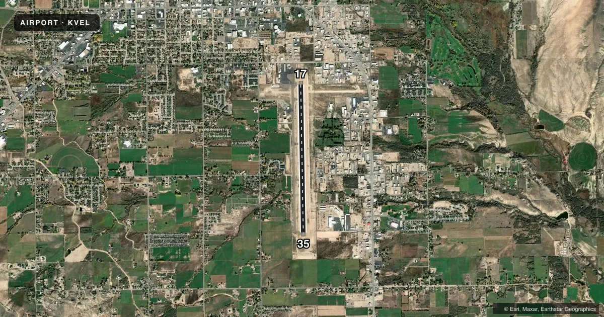
Runways & pattern
Full pagePattern entry · RWY 35
LEFT TRAFFICRunway end performance
| End | TORA | TODA | ASDA | LDA | VGSI | Approach lights | Obstruction |
|---|---|---|---|---|---|---|---|
| 17 | 7,000' | — | — | — | PAPI 4-box left(3°) | — | 33', pole, 586' from thr, 367' R of cntrln, slope 11 |
| 35 | 7,000' | — | — | — | PAPI 4-box left(3°) | — | 44', trees, 1094' from thr, 203' R of cntrln, slope 20 |
Declared distances in feet. TORA = takeoff run available, TODA = takeoff distance, ASDA = accelerate-stop, LDA = landing distance.
Airport sketch
Runways drawn to scale from FAA survey coordinates, rendered over satellite imagery. Not for navigation.
Approaches & charts
Services on the field
Fuel grades, oxygen, maintenance, ramp storage and lighting — as declared to the FAA by the airport operator.
Fuel & services
- Fuel
- 100LLA
- Oxygen (bulk)
- HIGH/LOW
- Airframe repair
- Major
- Power plant repair
- Major
- Other services
- AFRT,INSTR,RNTL
Ramp & ground
- Transient storage
- Tie-down
- Hangar
- Landing fee
- No fee published
- Customs
- Not available
- Lighting schedule
- SEE RMK
- Beacon schedule
- SS-SR
- Beacon
- White / Green (civil land)(WG)
- Wind indicator
- Lighted
- Segmented circle
- Yes
Fuel & FBOs
Cheapest 100LL and Jet A on the field and nearby. Always confirm with the FBO before taxi.
Airport notes
Surface conditions, obstructions, local procedures, lighting outages and other notes published with each FAA cycle.
General notes
- RWY 07/25 DECOMMISSIONED.
- FOR CD IF UNA TO CTC ON FSS FREQ, CTC SALT LAKE ARTCC AT 801-320-2568.
- COLD TEMPERATURE AIRPORT. ALTITUDE CORRECTION REQUIRED AT OR BELOW -26C.
Lighting notes
- ACTVT REIL RWY 17 & 35; MIRL RWY 17/35 - CTAF. PAPI RWY 17 & 35 ON CONSLY.
Runway surface & condition
- 17/35PCR VALUE: 230/F/D/X/T
Other notes
- 24 HR PPR FOR ACR OPS OVR 30 PAX SEATS - AMGR.
- 1AFT HR OPS CTC 435-789-8494 OR 435-261-9000.
VFR map & nearby airports
VFR sectional. Tap any ICAO chip to open that airport.
Key facts · KVEL
Answer card- ICAO
- KVEL
- Name
- VERNAL RGNL
- Location
- VERNAL, UTAH
- Elevation
- 5,274.2 ft MSL
- Traffic pattern altitude
- 6,274.2 ft MSL (1,000 AGL)
- Control tower
- Non-towered (use CTAF)
- Total runways
- 1
- Longest runway
- 17/35 · 7,000 ft
- Published ILS approaches
- 0
- Published frequencies
- 2
- Magnetic variation
- 10°
- Current flight rules
- VFR
- Current wind
- 340° at 3 kt
- Favored runway now
- RWY 35
Vernal Rgnl sits in Vernal, Utah. Field elevation is 5,274.2 ft MSL. The airport has one runway. Runway 17/35 is 7,000 ft asphalt. It is the longest runway on the field. There is no control tower. CTAF and UNICOM are both 122.7. No ILS approaches are published here, so plan with the current chart and weather in mind.
The published pattern altitude is not listed. Use the standard 1,000 ft AGL pattern unless local procedures or the current Chart Supplement say otherwise. The field has two on-field FBOs. Dinaland Aviation carries 100LL, Jet A and Jet A Prist. Classic Aviation carries 100LL, Jet A and Jet A Prist. If you need after-hours help, the published remarks say to call 435-789-8494 or 435-261-9000.
A few operational items matter here. Runway end identifier lights are installed on 17 and 35. Medium intensity runway lights are controlled by CTAF. PAPI is on continuously for both ends. The airport sits at high elevation. That means takeoff and climb performance deserve attention, especially on warm days. It is also a cold temperature airport. Altitude correction is required at or below minus 26 degrees Celsius. Runway 07/25 is decommissioned. If you need clearance delivery help and cannot reach flight service, contact Salt Lake ARTCC at 801-320-2568.