METAR & TAF 74V
Current METAR
Observed 16:35Z
K74V 261635Z AUTO VRB03KT 10SM CLR 30/10 A3018 RMK AO2
- Wind
- VAR @ 3 kt
- Visibility
- 10 SM
- Temp / Dew
- 30°C / 10°C
- Altimeter
- 30.18 inHg
- Clouds
- CLR
- Density alt
- 7,896 ft
- Ceiling
- Unlimited
- Rules
- VFR
Airport info & contacts
Manager on record, flight service, ARTCC, attendance schedule and pattern altitude — published by the FAA and refreshed every 28 days.
Location
- From city
- 3 NM SW
- VFR sectional
- SALT LAKE CITY
- ARTCC
- ZLC · SALT LAKE CITY
- NOTAM facility
- CDC (NOTAM-D)
Airport manager
- Name
- KIRBY WOLFINJER
- Phone
- 435-722-5001
- Address
- 255 S. STATE ST., ROOSEVELT UT 84066
Flight service · Hours
- FSS CDC
- CEDAR CITY1-800-WX-BRIEF
- Attendance
- Unattended
Frequencies
Tap any row to copy the frequency to your clipboard.
Runways & pattern
Full pagePattern entry · RWY 07
LEFT TRAFFICRunway end performance
| End | TORA | TODA | ASDA | LDA | VGSI | Approach lights | Obstruction |
|---|---|---|---|---|---|---|---|
| 07 | — | — | — | — | PAPI 4-box left(3°) | — | — |
| 25 | — | — | — | — | PAPI 4-box left(3°) | — | — |
Declared distances in feet. TORA = takeoff run available, TODA = takeoff distance, ASDA = accelerate-stop, LDA = landing distance.
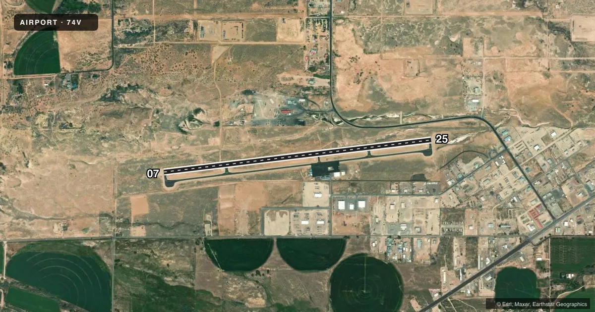
Airport sketch
Runways drawn to scale from FAA survey coordinates, rendered over satellite imagery. Not for navigation.
Approaches & charts
Services on the field
Fuel grades, oxygen, maintenance, ramp storage and lighting — as declared to the FAA by the airport operator.
Fuel & services
- Fuel
- 100LLA
- Airframe repair
- Major
- Power plant repair
- Major
- Other services
- INSTR,RNTL
Ramp & ground
- Transient storage
- Tie-down
- Hangar
- Landing fee
- No fee published
- Customs
- Not available
- Lighting schedule
- SEE RMK
- Beacon schedule
- SS-SR
- Beacon
- White / Green (civil land)(WG)
- Wind indicator
- Lighted
- Segmented circle
- Yes
Fuel & FBOs
Cheapest 100LL and Jet A on the field and nearby. Always confirm with the FBO before taxi.
Airport notes
Surface conditions, obstructions, local procedures, lighting outages and other notes published with each FAA cycle.
Lighting notes
- ACTVT & INCR INTST REIL RWY 07 & 25; MIRL RWY 7/25 - CTAF. PAPI RWY 07 & 25 ON CONSLY.
Other notes
- 1FOR SVC CALL 435-722-4558 OR 435-722-5001.
- MANAGERPUBLIC WORKS DIR/ARPT MGR.
VFR map & nearby airports
VFR sectional. Tap any ICAO chip to open that airport.
Key facts · 74V
Answer card- ICAO
- 74V
- Name
- ROOSEVELT MUNI
- Location
- ROOSEVELT, UTAH
- Elevation
- 5,176.1 ft MSL
- Traffic pattern altitude
- 6,176.1 ft MSL (1,000 AGL)
- Control tower
- Non-towered (use CTAF)
- Total runways
- 1
- Longest runway
- 07/25 · 6,501 ft
- Published ILS approaches
- 0
- Published frequencies
- 2
- Magnetic variation
- 10°
- Current flight rules
- VFR
- Current wind
- 000° at 3 kt
- Favored runway now
- RWY 07
Roosevelt Muni sits in Roosevelt, Utah. The field elevation is 5,176.1 ft MSL. It has one runway, 07/25, at 6,501 ft. There is no control tower. CTAF and UNICOM are both 122.8.
No ILS approaches are published here. The runway lighting is pilot-controlled on CTAF. The runway end identifier lights on 07 and 25 can be activated and their intensity increased. The PAPI on both ends is on continuously. For a first-time arrival, the big item is elevation. Expect high-density-altitude performance planning, especially on warm days. The published pattern altitude is not listed, so use the standard 1,000 ft AGL for light piston traffic unless the current Chart Supplement says otherwise.
Roosevelt Municipal Airport is the on-field FBO. It carries 100LL and Jet A. For service, the published numbers are 435-722-4558 and 435-722-5001. If you need current airport details or any local operating notes, check the current FAA Chart Supplement or call the airport operator directly before departure.