METAR & TAF U69
Current METAR
Observed 09:55Z
KU69 270955Z AUTO 35005KT 10SM CLR 26/08 A3017 RMK A01
- Wind
- 350° @ 5 kt
- Visibility
- 10 SM
- Temp / Dew
- 26°C / 8°C
- Altimeter
- 30.17 inHg
- Clouds
- CLR
- Density alt
- 8,240 ft
- Ceiling
- Unlimited
- Rules
- VFR
Airport info & contacts
Manager on record, flight service, ARTCC, attendance schedule and pattern altitude — published by the FAA and refreshed every 28 days.
Location
- From city
- 2 NM NE
- VFR sectional
- SALT LAKE CITY
- ARTCC
- ZLC · SALT LAKE CITY
- NOTAM facility
- CDC (NOTAM-D)
Airport manager
- Name
- RODNEY ROWLEY
- Phone
- 435-823-1292
- Address
- 500 E MAIN, DRAWER 974, DUCHESNE UT 84021
Flight service · Hours
- FSS CDC
- CEDAR CITY1-800-WX-BRIEF
- Attendance
- ON CALL
Frequencies
Tap any row to copy the frequency to your clipboard.
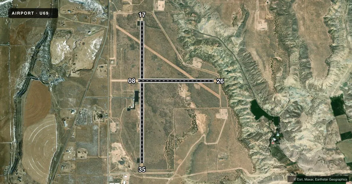
Runways & pattern
Full pagePattern entry · RWY 35
LEFT TRAFFIC| Runway | Heading (°M) | Length | Surface | Traffic |
|---|---|---|---|---|
| 17/35Favored | 165° / 345° | 5,800 ft | ASPH | Standard L |
| 08/26 | 75° / 255° | 3,091 ft | DIRT | Standard L |
Runway end performance
| End | TORA | TODA | ASDA | LDA | VGSI | Approach lights | Obstruction |
|---|---|---|---|---|---|---|---|
| 17 | — | — | — | — | PAPI 2-box left(3°) | — | 5', fence, 360' from thr, 0' R of cntrln, slope 20 |
| 35 | — | — | — | — | PAPI 2-box left(3°) | — | — |
| 08 | — | — | — | — | — | — | 10', road, 0' from thr, 125' R of cntrln, slope 0 |
| 26 | — | — | — | — | — | — | 10', road, 0' from thr, 125' R of cntrln, slope 0 |
Declared distances in feet. TORA = takeoff run available, TODA = takeoff distance, ASDA = accelerate-stop, LDA = landing distance.
Airport sketch
Runways drawn to scale from FAA survey coordinates, rendered over satellite imagery. Not for navigation.
Approaches & charts
Services on the field
Fuel grades, oxygen, maintenance, ramp storage and lighting — as declared to the FAA by the airport operator.
Fuel & services
- Fuel
- 100LL
- Oxygen (bottled)
- Not available
- Oxygen (bulk)
- Not available
- Airframe repair
- Not available
- Power plant repair
- Not available
- Other services
- AGRI
Ramp & ground
- Transient storage
- Tie-down
- Landing fee
- No fee published
- Customs
- Not available
- Lighting schedule
- SEE RMK
- Beacon schedule
- SS-SR
- Beacon
- White / Green (civil land)(WG)
- Wind indicator
- Lighted
- Segmented circle
- Yes
Fuel & FBOs
Cheapest 100LL and Jet A on the field and nearby. Always confirm with the FBO before taxi.
Airport notes
Surface conditions, obstructions, local procedures, lighting outages and other notes published with each FAA cycle.
Lighting notes
- ACTVT REIL RWY 17 & 35, PAPI RWY 17 & 35, MIRL RWY 17/35 - CTAF.
Fuel notes
- 100LL24 HR SELF SVC. AMERICAN EXPS CREDIT CARD NOT ACPTD.
Approach & departure obstructions
- 0830 FT PLINES & OIL WELLS WEST SIDE RWY 08.
- 0810 FT PVT RD ACRS APCH.
Other notes
- EXISTED PRIOR TO 1959.
- PILOT PRVD OWN ROPES.
- 08/263000 FT OF USBL RWY LENGTH EAST OF RWY 17/35.
VFR map & nearby airports
VFR sectional. Tap any ICAO chip to open that airport.
Key facts · U69
Answer card- ICAO
- U69
- Name
- DUCHESNE MUNI
- Location
- DUCHESNE, UTAH
- Elevation
- 5,830.9 ft MSL
- Traffic pattern altitude
- 6,830.9 ft MSL (1,000 AGL)
- Control tower
- Non-towered (use CTAF)
- Total runways
- 2
- Longest runway
- 17/35 · 5,800 ft
- Published ILS approaches
- 0
- Published frequencies
- 2
- Magnetic variation
- 15°
- Current flight rules
- VFR
- Current wind
- 350° at 5 kt
- Favored runway now
- RWY 35
Duchesne Muni sits in Duchesne, Utah. Field elevation is 5,830.9 ft MSL. The airport has two runways. The longest is 5,800 ft on runway 17/35. Runway 08/26 is 3,091 ft dirt. There is no control tower. CTAF and UNICOM are both 122.8. No ILS approaches are published.
Pattern altitude is not published. Use the standard 1,000 ft AGL for light piston operations unless the current Chart Supplement says otherwise. That puts the light-aircraft pattern at about 6,830.9 ft MSL. This is a high-elevation field. Expect performance to matter, especially on warm days.
Published remarks matter here. There are 30-foot power lines and oil wells on the west side of runway 08. There is also a 10-foot private road across the approach to runway 08. Runway 17/35 has runway end identifier lights, PAPI and medium intensity runway lights that are controlled from CTAF. Fuel is available 24 hours self-service. Pilots provide their own ropes. No on-field FBOs are listed, so call the airport operator or the field directly before arrival if you need current service details.