METAR & TAF 33U
33U does not publish a METAR.
Showing the nearest reporting station: KVEL (VERNAL RGNL) · 29.4 NM away. Conditions at 33U may differ.
METAR · KVEL
Observed 03:53Z
KVEL 270353Z AUTO VRB05KT 10SM -RA FEW080 SCT110 31/08 A3011 RMK AO2 RAB33 SLP109 P0000 T03110083 $
- Wind
- VAR @ 5 kt
- Visibility
- 10 SM
- Temp / Dew
- 31°C / 8°C
- Altimeter
- 30.11 inHg
- Clouds
- SCT
- Density alt
- 9,820 ft
- Ceiling
- Unlimited
- Rules
- VFR
Airport info & contacts
Manager on record, flight service, ARTCC, attendance schedule and pattern altitude — published by the FAA and refreshed every 28 days.
Location
- From city
- 1 NM SW
- VFR sectional
- SALT LAKE CITY
- ARTCC
- ZLC · SALT LAKE CITY
- NOTAM facility
- CDC (NOTAM-D)
Airport manager
- Name
- RANDY ASAY
- Phone
- 307-780-8019
- Address
- 95 NORTH 1ST WEST, PO BOX 219, MANILA UT 84046-0219
Flight service · Hours
- FSS CDC
- CEDAR CITY1-800-WX-BRIEF
- Attendance
- Unattended
Frequencies
Tap any row to copy the frequency to your clipboard.
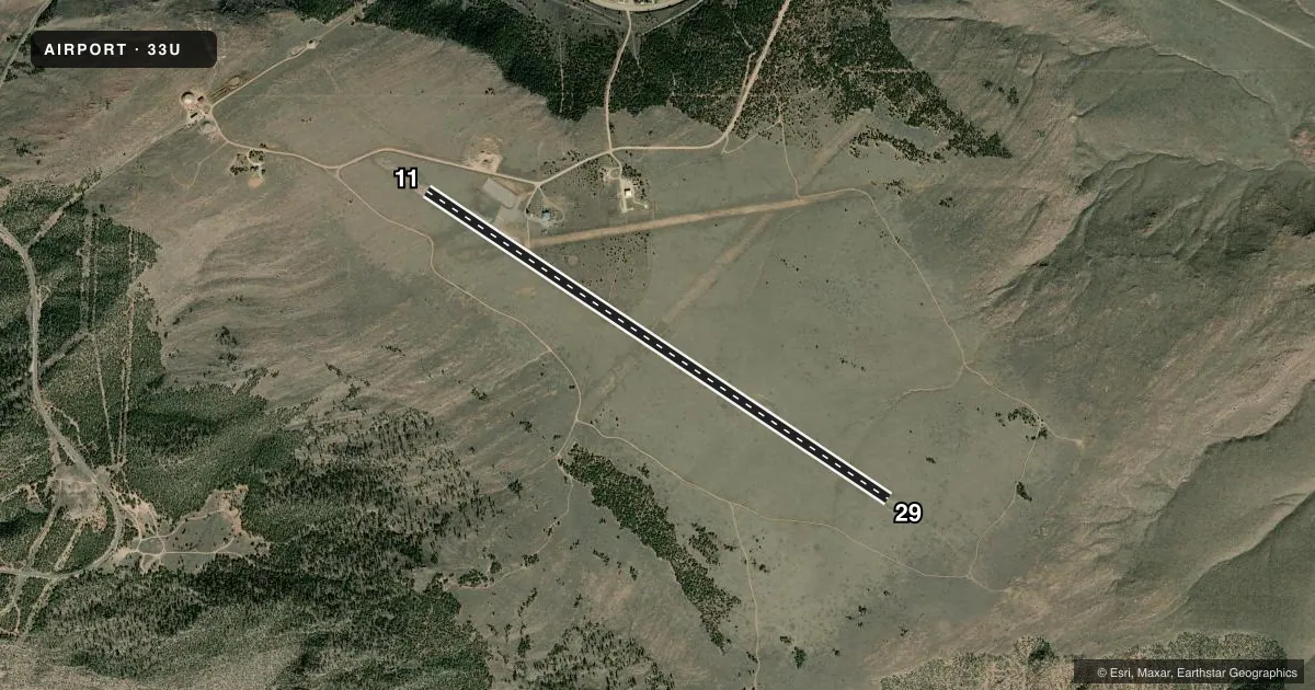
Runways & pattern
Full pagePattern entry · RWY 29
LEFT TRAFFICAirport sketch
Runways drawn to scale from FAA survey coordinates, rendered over satellite imagery. Not for navigation.
Approaches & charts
Services on the field
Fuel grades, oxygen, maintenance, ramp storage and lighting — as declared to the FAA by the airport operator.
Fuel & services
- Fuel
- Not available
- Oxygen (bottled)
- Not available
- Oxygen (bulk)
- Not available
- Airframe repair
- Not available
- Power plant repair
- Not available
Ramp & ground
- Transient storage
- Tie-down
- Landing fee
- No fee published
- Customs
- Not available
- Wind indicator
- Yes
- Segmented circle
- No
Fuel & FBOs
Cheapest 100LL and Jet A on the field and nearby. Always confirm with the FBO before taxi.
Airport notes
Surface conditions, obstructions, local procedures, lighting outages and other notes published with each FAA cycle.
General notes
- DEER AND ELK ON AND INVOF ARPT.
- TWO XNG DIRT/TURF RWYS APPEAR TO BE OPN BUT ARE CLSD & NOT MNTND.
- ACFT IN EXCESS OF 12,500 LBS MAX GWT PROHIBITED FM USING APRT.
- FOR CD CTC SALT LAKE ARTCC AT 801-320-2568.
Runway surface & condition
- 07/25USE CTN; XS RWY 11/29.
Other notes
- 1IREG SN REMOVAL. CALL FOR FICONS.
- MANAGERCOUNTY CLERK/AMGR.
- 07/25NOT MNTND. ROUGH, UNEVEN SFC. POSS ANIMAL HOLES; TREES ON APCH ENDS.
VFR map & nearby airports
VFR sectional. Tap any ICAO chip to open that airport.
Key facts · 33U
Answer card- ICAO
- 33U
- Name
- DUTCH JOHN
- Location
- DUTCH JOHN, UTAH
- Elevation
- 6,561 ft MSL
- Traffic pattern altitude
- 7,561 ft MSL (1,000 AGL)
- Control tower
- Non-towered (use CTAF)
- Total runways
- 1
- Longest runway
- 11/29 · 6,000 ft
- Published ILS approaches
- 0
- Published frequencies
- 1
- Magnetic variation
- 14°
- Current flight rules
- VFR
- Current wind
- 000° at 5 kt
- Favored runway now
- RWY 29
Dutch John Airport (33U) sits in Dutch John, Utah. The field elevation is 6,561 ft MSL. It has one runway. Runway 11/29 is 6,000 ft long and asphalt. There is no control tower. CTAF is 122.9. No ILS approaches are published.
Pattern altitude is not published. Use 1,000 ft AGL as the standard light-piston pattern unless the current Chart Supplement or local procedures say otherwise. That puts the pattern at about 7,561 ft MSL. The airport sits at high elevation, so expect reduced climb performance and a longer takeoff roll than you would see at lower fields. Deer and elk are reported on and near the airport. That matters on taxi, takeoff and landing.
Published remarks also say snow removal can be irregular. Call for field conditions before you go. Two dirt and turf runways appear in some references. They are closed and not maintained. Runway 07/25 is closed indefinitely. It is not inspected. Aircraft over 12,500 pounds maximum gross weight are prohibited. For clearance delivery, contact Salt Lake ARTCC at 801-320-2568. There are no on-field FBOs listed, so verify services with the airport operator or the FBO directly by phone before arrival.