METAR & TAF KAXX
Current METAR
Observed 06:35Z
KAXX 270635Z AUTO 00000KT 10SM SCT100 OVC120 15/14 A3045 RMK AO2 T01470135
- Wind
- 000° @ 0 kt
- Visibility
- 10 SM
- Temp / Dew
- 15°C / 14°C
- Altimeter
- 30.45 inHg
- Clouds
- OVC
- Density alt
- 9,733 ft
- Ceiling
- 12,000 ft AGL
- Rules
- VFR
Airport info & contacts
Manager on record, flight service, ARTCC, attendance schedule and pattern altitude — published by the FAA and refreshed every 28 days.
Location
- From city
- 1 NM N
- VFR sectional
- DENVER
- ARTCC
- ZAB · ALBUQUERQUE
- NOTAM facility
- ABQ (NOTAM-D)
Airport manager
- Name
- JEFFERY GILMER
- Phone
- 575-447-1194
- Address
- PO BOX 610, ANGEL FIRE NM 87710
Flight service · Hours
- FSS ABQ
- ALBUQUERQUE1-800-WX-BRIEF
- Attendance
- 0800-1630
Frequencies
Tap any row to copy the frequency to your clipboard.
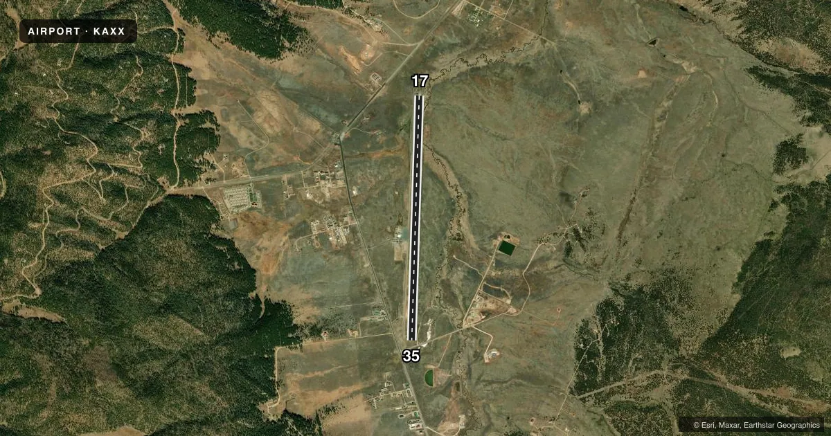
Runways & pattern
Full pagePattern entry · RWY 17
LEFT TRAFFICRunway end performance
| End | TORA | TODA | ASDA | LDA | VGSI | Approach lights | Obstruction |
|---|---|---|---|---|---|---|---|
| 17 | — | — | — | — | PAPI 2-box left(3.05°) | — | 118', gnd, 2576' from thr, 360' R of cntrln, slope 20 |
| 35 | — | — | — | — | — | — | 8', road, 360' from thr, 0' R of cntrln, slope 20 |
Declared distances in feet. TORA = takeoff run available, TODA = takeoff distance, ASDA = accelerate-stop, LDA = landing distance.
Airport sketch
Runways drawn to scale from FAA survey coordinates, rendered over satellite imagery. Not for navigation.
Approaches & charts
Services on the field
Fuel grades, oxygen, maintenance, ramp storage and lighting — as declared to the FAA by the airport operator.
Fuel & services
- Fuel
- 100LLA+
Ramp & ground
- Transient storage
- Tie-down
- Hangar
- Landing fee
- No fee published
- Lighting schedule
- SEE RMK
- Beacon schedule
- SEE RMK
- Beacon
- White / Green (civil land)(WG)
- Wind indicator
- Lighted
- Segmented circle
- Yes
Fuel & FBOs
Cheapest 100LL and Jet A on the field and nearby. Always confirm with the FBO before taxi.
Airport notes
Surface conditions, obstructions, local procedures, lighting outages and other notes published with each FAA cycle.
General notes
- ARPT LCTD IN MOUNTAIN VALLEY; RISING TERRAIN IN ALL DIRECTIONS. STRONG GUSTY CROSSWINDS POSSIBLE. HIGH DENSITY ALTITUDE PROBABLE.
- 6-8 INCH DROP OFF AT THLD OF RWY 17.
- AVOID OVERFLIGHT OF TAOS PUEBLO WORLD HERITGE SITE WEST OF ARPT.
- COLD TEMPERATURE AIRPORT. ALTITUDE CORRECTION REQUIRED AT OR BELOW -29C.
- FOR CD CTC ALBUQUERQUE ARTCC AT 505-856-4861.
Lighting notes
- ACTVT ROTG BCN - CTAF.
- ACTVT REIL RWY 17 & 35; MIRL RWY 17/35 - CTAF. PAPI RWY 17 ON CONSLY.
Fuel notes
- 100LL24 HR. SELF SERVE 100LL, JETA+ WITH MAJOR CREDIT CARD
Other notes
- CALL 575-449-1194 FOR AVBLTY.
VFR map & nearby airports
VFR sectional. Tap any ICAO chip to open that airport.
Key facts · KAXX
Answer card- ICAO
- KAXX
- Name
- ANGEL FIRE
- Location
- ANGEL FIRE, NEW MEXICO
- Elevation
- 8,379.5 ft MSL
- Traffic pattern altitude
- 9,379.5 ft MSL (1,000 AGL)
- Control tower
- Non-towered (use CTAF)
- Total runways
- 1
- Longest runway
- 17/35 · 8,900 ft
- Published ILS approaches
- 0
- Published frequencies
- 2
- Magnetic variation
- 10°
- Current flight rules
- VFR
- Current wind
- 000° at 0 kt
- Favored runway now
- –
Angel Fire Airport sits in Angel Fire, New Mexico. The field elevation is 8,379.5 ft MSL. It has one runway, 17/35, which is 8,900 ft long and paved. There is no control tower. CTAF and UNICOM are both 122.8. No ILS approaches are published.
Pattern altitude is not published. Use the standard 1,000 ft AGL pattern unless local procedures or current chart data say otherwise. The airport is in a mountain valley with rising terrain in all directions. Expect high density altitude. Strong gusty crosswinds are possible. That matters here more than at a low-elevation strip.
Angel Fire Airport is on the field. It carries Jet A and 100LL. Published remarks say 24-hour self-serve fuel is available with a major credit card. The runway lights and runway end identifier lights are activated on CTAF. The PAPI for runway 17 is on continuously. There is a six to eight inch drop-off at the threshold of runway 17. Avoid overflight of Taos Pueblo World Heritage Site west of the airport. For clearance delivery, contact Albuquerque ARTCC at 505-856-4861. If you are planning a winter arrival, note that this is a cold temperature airport and altitude correction is required at or below minus 29 degrees Celsius.