METAR & TAF KLVS
Current METAR
Observed 14:53Z
KLVS 271453Z AUTO 32004KT 10SM CLR 26/13 A3027 RMK AO2 SLP122 T02560133 51004
- Wind
- 320° @ 4 kt
- Visibility
- 10 SM
- Temp / Dew
- 26°C / 13°C
- Altimeter
- 30.27 inHg
- Clouds
- CLR
- Density alt
- 9,414 ft
- Ceiling
- Unlimited
- Rules
- VFR
Airport info & contacts
Manager on record, flight service, ARTCC, attendance schedule and pattern altitude — published by the FAA and refreshed every 28 days.
Location
- From city
- 5 NM NE
- VFR sectional
- ALBUQUERQUE
- ARTCC
- ZAB · ALBUQUERQUE
- NOTAM facility
- LVS (NOTAM-D)
Airport manager
- Name
- JOHN ARAGON
- Phone
- 505-454-0881
- Address
- 910 AIRPORT ROAD, LAS VEGAS NM 87701
Flight service · Hours
- FSS ABQ
- ALBUQUERQUE1-800-WX-BRIEF
- Attendance
- MON-FRI · 0800-1630
Frequencies
Tap any row to copy the frequency to your clipboard.
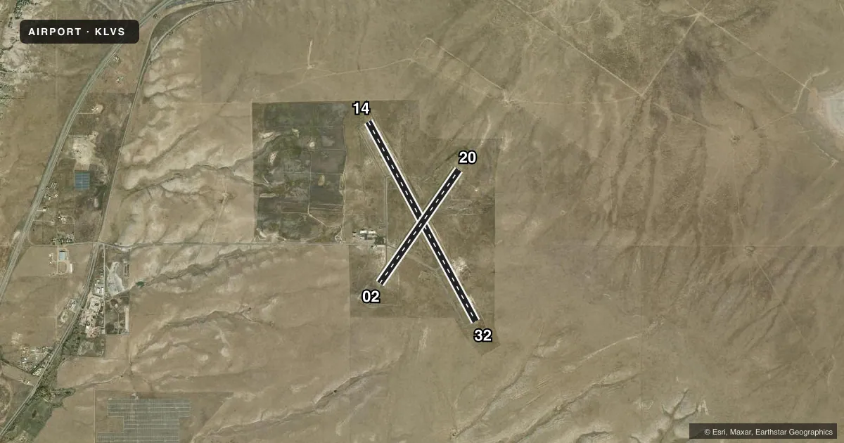
Runways & pattern
Full pagePattern entry · RWY 32
LEFT TRAFFIC| Runway | Heading (°M) | Length | Surface | Traffic |
|---|---|---|---|---|
| 14/32Favored | 139° / 319° | 8,199 ft | ASPH | Standard L |
| 02/20 | 22° / 202° | 5,006 ft | ASPH | Standard L |
Runway end performance
| End | TORA | TODA | ASDA | LDA | VGSI | Approach lights | Obstruction |
|---|---|---|---|---|---|---|---|
| 14 | — | — | — | — | PAPI 2-box left(3°) | — | — |
| 32 | — | — | — | — | PAPI 2-box left(3°) | — | — |
| 02 | — | — | — | — | PAPI 2-box left(3°) | ODALS | — |
| 20 | — | — | — | — | PAPI 2-box left(3°) | ODALS | — |
Declared distances in feet. TORA = takeoff run available, TODA = takeoff distance, ASDA = accelerate-stop, LDA = landing distance.
Airport sketch
Runways drawn to scale from FAA survey coordinates, rendered over satellite imagery. Not for navigation.
Approaches & charts
Services on the field
Fuel grades, oxygen, maintenance, ramp storage and lighting — as declared to the FAA by the airport operator.
Fuel & services
- Fuel
- 100LLA1
Ramp & ground
- Transient storage
- Tie-down
- Customs
- Not available
- Lighting schedule
- SEE RMK
- Beacon schedule
- SS-SR
- Beacon
- White / Green (civil land)(WG)
- Wind indicator
- Lighted
- Segmented circle
- Yes
Fuel & FBOs
Cheapest 100LL and Jet A on the field and nearby. Always confirm with the FBO before taxi.
Airport notes
Surface conditions, obstructions, local procedures, lighting outages and other notes published with each FAA cycle.
General notes
- BIRDS ON & INVOF ARPT.
- NMRS HOLD & DRCTN SIGNS OTS.
- FOR CD IF UNA TO CTC ON FSS FREQ, CTC ALBUQUERQUE ARTCC AT 505-856-4561.
- FUEL 24 HR SELF SVC WITH CREDIT CARD.
Lighting notes
- ACTVT PAPI RWY 02, 20, 14, 32; MIRL RWY 02/20 & 14/32 - CTAF.
Approach & departure obstructions
- 02OTS INDEFLY.
- 20OTS INDEFLY.
Other notes
- 1IF UNAVBL - EMERG 505-429-3198 OR 505-425-7504.
VFR map & nearby airports
VFR sectional. Tap any ICAO chip to open that airport.
Key facts · KLVS
Answer card- ICAO
- KLVS
- Name
- LAS VEGAS MUNI
- Location
- LAS VEGAS, NEW MEXICO
- Elevation
- 6,877.2 ft MSL
- Traffic pattern altitude
- 7,877.2 ft MSL (1,000 AGL)
- Control tower
- Non-towered (use CTAF)
- Total runways
- 2
- Longest runway
- 14/32 · 8,199 ft
- Published ILS approaches
- 0
- Published frequencies
- 2
- Magnetic variation
- 13°
- Current flight rules
- VFR
- Current wind
- 320° at 4 kt
- Favored runway now
- RWY 32
Las Vegas Muni sits in Las Vegas, New Mexico. The field elevation is 6,877.2 ft MSL. It has two asphalt runways. The longest is 8,199 ft on runway 14/32. There is no control tower. CTAF and UNICOM are both 122.8. No ILS approaches are published.
Pattern altitude is not published. Use 1,000 ft AGL for light piston operations unless the current Chart Supplement says otherwise. That puts the normal traffic pattern at about 7,877 ft MSL. The airport is high enough that density altitude can matter on warm days. Plan performance with that in mind.
The on-field FBO is Las Vegas Municipal Airport. It carries JET_A_PRIST. Fuel is available 24 hours by self-service with a credit card. The published remarks also note birds on and near the airport. Runway 02 and runway 20 have approach lighting systems out of service indefinitely. Numbered hold and direction signs are also out of service. PAPI is available for runways 02, 20, 14 and 32. Medium intensity runway lights on both runways are controlled by CTAF. For clearance delivery, if Flight Service is not available, contact Albuquerque ARTCC. First-time visitors should also review the current Chart Supplement for any local procedures before arrival.