METAR & TAF S42
S42 does not publish a METAR.
Showing the nearest reporting station: KRTN (RATON MUNI/CREWS FLD) · 25.3 NM away. Conditions at S42 may differ.
METAR · KRTN
Observed 20:53Z
KRTN 262053Z AUTO 20007KT 10SM CLR 35/07 RMK AO2 LTG DSNT W AND NW SLPNO T03500072
- Wind
- 200° @ 7 kt
- Visibility
- 10 SM
- Temp / Dew
- 35°C / 7°C
- Altimeter
- —
- Clouds
- CLR
- Density alt
- 9,709 ft
- Ceiling
- Unlimited
- Rules
- VFR
Airport info & contacts
Manager on record, flight service, ARTCC, attendance schedule and pattern altitude — published by the FAA and refreshed every 28 days.
Location
- From city
- 1 NM S
- VFR sectional
- DENVER
- ARTCC
- ZAB · ALBUQUERQUE
- NOTAM facility
- ABQ (NOTAM-D)
Airport manager
- Name
- CRAIG EPPLER
- Phone
- 575-483-2682
- Address
- P.O. BOX 488, SPRINGER NM 87747
Flight service · Hours
- FSS ABQ
- ALBUQUERQUE1-800-WX-BRIEF
- Attendance
- Unattended
Frequencies
Tap any row to copy the frequency to your clipboard.
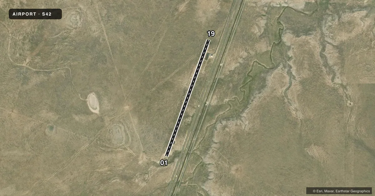
Runways & pattern
Full pagePattern entry · RWY 19
LEFT TRAFFICRunway end performance
| End | TORA | TODA | ASDA | LDA | VGSI | Approach lights | Obstruction |
|---|---|---|---|---|---|---|---|
| 01 | — | — | — | — | — | — | 18', hill, 1000' from thr, 0' R of cntrln, slope 44 |
Declared distances in feet. TORA = takeoff run available, TODA = takeoff distance, ASDA = accelerate-stop, LDA = landing distance.
Airport sketch
Runways drawn to scale from FAA survey coordinates, rendered over satellite imagery. Not for navigation.
Approaches & charts
Services on the field
Fuel grades, oxygen, maintenance, ramp storage and lighting — as declared to the FAA by the airport operator.
Fuel & services
- Fuel
- Not available
Ramp & ground
- Transient storage
- Tie-down
- Landing fee
- No fee published
- Customs
- Not available
- Lighting schedule
- SEE RMK
- Beacon schedule
- SS-SR
- Beacon
- White / Green (civil land)(WG)
- Wind indicator
- Lighted
- Segmented circle
- Yes
Fuel & FBOs
Cheapest 100LL and Jet A on the field and nearby. Always confirm with the FBO before taxi.
Airport notes
Surface conditions, obstructions, local procedures, lighting outages and other notes published with each FAA cycle.
General notes
- RY ARPT ROAD GATES LOCKED; FOR ENTRY & EXIT CALL 575-483-2682 BEFORE ARRIVAL. NO PHONE ON ARPT.
- WILDLIFE ON & INVOF ARPT.
- FOR CD CTC ALBUQUERQUE ARTCC AT 505-856-4861.
- ACES GATE #2020.
Lighting notes
- ACTVT MIRL RWY 01/19 - CTAF. MIRL RWY 01/19 PRESET LOW INTST; INCR INTST - CTAF.
Approach & departure obstructions
- 193-10 FT DROP OFF 30 FT FM EDGE W SIDE ALG FIRST 300 FT FM THR.
Other notes
- MANAGEREMERG - 575-707-0265.
VFR map & nearby airports
VFR sectional. Tap any ICAO chip to open that airport.
Key facts · S42
Answer card- ICAO
- S42
- Name
- SPRINGER MUNI
- Location
- SPRINGER, NEW MEXICO
- Elevation
- 5,894 ft MSL
- Traffic pattern altitude
- 6,894 ft MSL (1,000 AGL)
- Control tower
- Non-towered (use CTAF)
- Total runways
- 1
- Longest runway
- 01/19 · 5,003 ft
- Published ILS approaches
- 0
- Published frequencies
- 1
- Magnetic variation
- 11°
- Current flight rules
- VFR
- Current wind
- 200° at 7 kt
- Favored runway now
- RWY 19
Springer Muni is in Springer, New Mexico. The field elevation is 5,894 ft MSL. It has one runway, 01/19, which is 5,003 ft long and asphalt. There is no control tower. CTAF is 122.9.
No ILS approaches are published here. The pattern altitude is not published, so use the standard 1,000 ft AGL unless the current Chart Supplement says otherwise. At this elevation, performance planning matters. Expect the airplane to feel the altitude on takeoff and climb.
The runway lights on 01/19 are medium intensity and are activated by CTAF. They are preset to low intensity. Increase intensity by CTAF if needed. For clearance delivery, contact Albuquerque ARTCC at 505-856-4861. Access is controlled by locked runway airport road gates. Call 575-483-2682 before arrival for entry and exit. There is no phone on the airport.
There are no on-field FBOs listed. Wildlife is reported on and near the airport. There is also a drop-off on the west side along the first 300 feet from the threshold of runway 19. A first-time pilot should plan a careful taxi and landing rollout, then verify current field conditions before departure.