METAR & TAF E89
E89 does not publish a METAR.
Showing the nearest reporting station: KTCC (TUCUMCARI MUNI) · 30.4 NM away. Conditions at E89 may differ.
METAR · KTCC
Observed 12:53Z
KTCC 271253Z AUTO 22006KT 10SM CLR 26/13 A3002 RMK AO2 SLP085 T02560133 $
- Wind
- 220° @ 6 kt
- Visibility
- 10 SM
- Temp / Dew
- 26°C / 13°C
- Altimeter
- 30.02 inHg
- Clouds
- CLR
- Density alt
- 6,444 ft
- Ceiling
- Unlimited
- Rules
- VFR
Airport info & contacts
Manager on record, flight service, ARTCC, attendance schedule and pattern altitude — published by the FAA and refreshed every 28 days.
Location
- From city
- 1 NM SW
- VFR sectional
- ALBUQUERQUE
- ARTCC
- ZAB · ALBUQUERQUE
- NOTAM facility
- ABQ (NOTAM-D)
Airport manager
- Name
- JANE LUCERO
- Phone
- 505-365-3891
- Address
- 3501 ACCESS RD C, PO BOX 9830, ALBUQUERQUE NM 87106
Flight service · Hours
- FSS ABQ
- ALBUQUERQUE1-800-WX-BRIEF
- Attendance
- Unattended
Frequencies
Tap any row to copy the frequency to your clipboard.
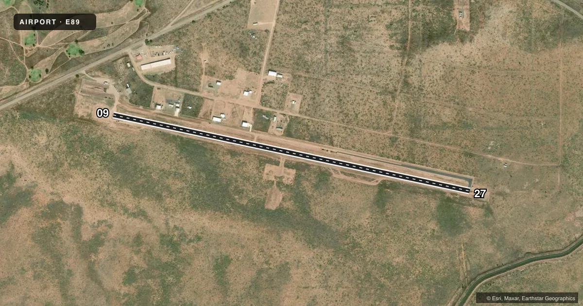
Runways & pattern
Full pagePattern entry · RWY 27
LEFT TRAFFICRunway end performance
| End | TORA | TODA | ASDA | LDA | VGSI | Approach lights | Obstruction |
|---|---|---|---|---|---|---|---|
| 09 | — | — | — | — | — | ODALS | — |
| 27 | — | — | — | — | — | ODALS | — |
Declared distances in feet. TORA = takeoff run available, TODA = takeoff distance, ASDA = accelerate-stop, LDA = landing distance.
Airport sketch
Runways drawn to scale from FAA survey coordinates, rendered over satellite imagery. Not for navigation.
Approaches & charts
Services on the field
Fuel grades, oxygen, maintenance, ramp storage and lighting — as declared to the FAA by the airport operator.
Fuel & services
- Fuel
- Not available
Ramp & ground
- Transient storage
- Tie-down
- Landing fee
- No fee published
- Customs
- Not available
- Lighting schedule
- SEE RMK
- Beacon schedule
- SS-SR
- Beacon
- White / Green (civil land)(WG)
- Wind indicator
- Lighted
- Segmented circle
- Yes
Fuel & FBOs
Cheapest 100LL and Jet A on the field and nearby. Always confirm with the FBO before taxi.
Airport notes
Surface conditions, obstructions, local procedures, lighting outages and other notes published with each FAA cycle.
General notes
- TWYS HAVE RETRO REFLECTIVE MKRS.
- WILDLIFE ON & INVOF ARPT.
- GATE ACES 4230.
- FOR CD CTC ALBUQUERQUE ARTCC AT 505-856-4861.
Lighting notes
- ACTVT ODALS RWY 09 & 27 - CTAF.
Runway surface & condition
- 09/27REFLECTIVE MKRS.
Approach & departure obstructions
- 09NSTD; ONE ODAL ILLUMINATES.
- 27NSTD; OTS INDEFLY.
- 09+5 FT SURVEY MKR 75 FT FM RWY END 52 FT L OF CNTRLN.
- 27+4 FT BRUSH 35 FT FM THR 110 FT R OF CNTRLN; 2-4 FT BRUSH 175 FT FM THR 75-125 FT L OF CNTRLN.
- 27SURVEY MKR 275 FT FM THR 55 FT L OF CNTRLN.
VFR map & nearby airports
VFR sectional. Tap any ICAO chip to open that airport.
Key facts · E89
Answer card- ICAO
- E89
- Name
- CONCHAS LAKE
- Location
- CONCHAS DAM, NEW MEXICO
- Elevation
- 4,232.3 ft MSL
- Traffic pattern altitude
- 5,232.3 ft MSL (1,000 AGL)
- Control tower
- Non-towered (use CTAF)
- Total runways
- 1
- Longest runway
- 09/27 · 4,800 ft
- Published ILS approaches
- 0
- Published frequencies
- 1
- Magnetic variation
- 10°
- Current flight rules
- VFR
- Current wind
- 220° at 6 kt
- Favored runway now
- RWY 27
Conchas Lake Airport (E89) sits at Conchas Dam, New Mexico. Field elevation is 4,232.3 ft MSL. The airport has one runway. Runway 09/27 is 4,800 ft long with asphalt pavement. There is no control tower. CTAF is 122.9.
No ILS approaches are published here. The published pattern altitude is not listed, so use the current Chart Supplement before you go. For light piston traffic, a standard 1,000 ft AGL pattern is often used when no local pattern is published, but verify that before flight. The airport notes nonstandard approach lighting on both ends. Runway 27 lighting is out of service indefinitely. The approach lights for runways 09 and 27 activate on CTAF.
There are no on-field FBOs listed, so plan ahead for fuel and ground support. Wildlife is reported on and near the airport. There are also published obstructions near both runway ends, including brush and survey markers. Taxiways use retro reflective markers. For clearance delivery, contact Albuquerque ARTCC at 505-856-4861. At this elevation, performance planning matters. Expect higher takeoff and climb distances than at low-elevation fields. Check density altitude before departure.