METAR & TAF N17
N17 does not publish a METAR.
Showing the nearest reporting station: KSXU (SANTA ROSA ROUTE 66) · 33.6 NM away. Conditions at N17 may differ.
METAR · KSXU
Observed 13:15Z
KSXU 271315Z AUTO 14007KT 10SM CLR 23/13 A3008 RMK AO2
- Wind
- 140° @ 7 kt
- Visibility
- 10 SM
- Temp / Dew
- 23°C / 13°C
- Altimeter
- 30.08 inHg
- Clouds
- CLR
- Density alt
- 8,122 ft
- Ceiling
- Unlimited
- Rules
- VFR
Airport info & contacts
Manager on record, flight service, ARTCC, attendance schedule and pattern altitude — published by the FAA and refreshed every 28 days.
Location
- From city
- 1 NM NE
- VFR sectional
- ALBUQUERQUE
- ARTCC
- ZAB · ALBUQUERQUE
- NOTAM facility
- ABQ (NOTAM-D)
Airport manager
- Name
- MAYOR ROMAN GARCIA
- Phone
- 575-584-2301
- Address
- PO BOX 278, VAUGHN NM 88353
Flight service · Hours
- FSS ABQ
- ALBUQUERQUE1-800-WX-BRIEF
- Attendance
- Unattended
Frequencies
Tap any row to copy the frequency to your clipboard.
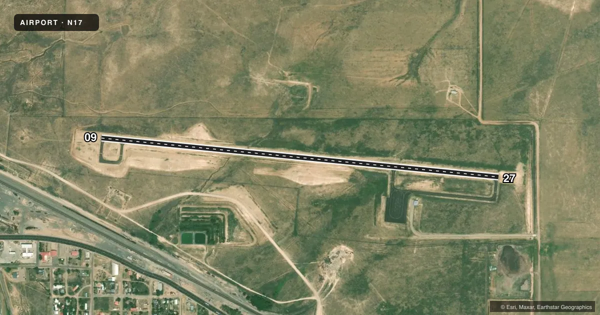
Runways & pattern
Full pagePattern entry · RWY 09
LEFT TRAFFICAirport sketch
Runways drawn to scale from FAA survey coordinates, rendered over satellite imagery. Not for navigation.
Approaches & charts
Services on the field
Fuel grades, oxygen, maintenance, ramp storage and lighting — as declared to the FAA by the airport operator.
Fuel & services
- Fuel
- Not available
Ramp & ground
- Transient storage
- Not published
- Wind indicator
- Yes
- Segmented circle
- Yes
Fuel & FBOs
Cheapest 100LL and Jet A on the field and nearby. Always confirm with the FBO before taxi.
Airport notes
Surface conditions, obstructions, local procedures, lighting outages and other notes published with each FAA cycle.
General notes
- FOR CD CTC ALBUQUERQUE ARTCC AT 505-856-4861.
Runway surface & condition
- 09/27417 FT TWRS 1 MI S.
Other notes
- MANAGEREMERG - 575-472-3711.
VFR map & nearby airports
VFR sectional. Tap any ICAO chip to open that airport.
Key facts · N17
Answer card- ICAO
- N17
- Name
- VAUGHN MUNI
- Location
- VAUGHN, NEW MEXICO
- Elevation
- 5,935.9 ft MSL
- Traffic pattern altitude
- 6,935.9 ft MSL (1,000 AGL)
- Control tower
- Non-towered (use CTAF)
- Total runways
- 1
- Longest runway
- 09/27 · 5,150 ft
- Published ILS approaches
- 0
- Published frequencies
- 1
- Magnetic variation
- –
- Current flight rules
- VFR
- Current wind
- 140° at 7 kt
- Favored runway now
- RWY 09
Vaughn Muni sits in Vaughn, New Mexico at 5,935.9 ft MSL. It has one runway, 09/27, which is 5,150 ft long and paved asphalt. The field is not towered. CTAF is 122.9. No ILS approaches are published here, so plan with the current charted procedures and the weather on the day of flight.
Pattern altitude is not published. Use 1,000 ft AGL for light piston operations unless the current Chart Supplement says otherwise. That puts the standard pattern roughly at 6,936 ft MSL. The airport sits in high terrain country. Density altitude can be a real factor here, especially on warm days.
Published remarks call out 417 ft towers about 1 mile south of the airport. That is worth keeping in mind on departure and arrival. For clearance delivery, contact Albuquerque ARTCC at 505-856-4861. No on-field FBOs are listed in the provided facts, so verify fuel and services with the airport operator or call the field directly before you go.