METAR & TAF 0E0
Current METAR
Observed 18:35Z
K0E0 271835Z AUTO 01006KT 10SM CLR 34/09 A3022 RMK AO2 T03390091
- Wind
- 010° @ 6 kt
- Visibility
- 10 SM
- Temp / Dew
- 34°C / 9°C
- Altimeter
- 30.22 inHg
- Clouds
- CLR
- Density alt
- 9,601 ft
- Ceiling
- Unlimited
- Rules
- VFR
Airport info & contacts
Manager on record, flight service, ARTCC, attendance schedule and pattern altitude — published by the FAA and refreshed every 28 days.
Location
- From city
- 2 NM SE
- VFR sectional
- ALBUQUERQUE
- ARTCC
- ZAB · ALBUQUERQUE
- NOTAM facility
- 0E0 (NOTAM-D)
Airport manager
- Name
- BOB HUDSON
- Phone
- 505-832-5072
- Address
- PO BOX 130, MORIARTY NM 87035
Flight service · Hours
- FSS ABQ
- ALBUQUERQUE1-800-WX-BRIEF
- Attendance
- 0800-1700
Frequencies
Tap any row to copy the frequency to your clipboard.
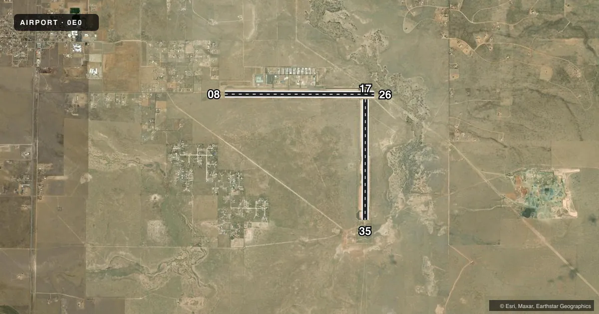
Runways & pattern
Full pagePattern entry · RWY 35
LEFT TRAFFIC| Runway | Heading (°M) | Length | Surface | Traffic |
|---|---|---|---|---|
| 08/26 | 79° / 259° | 7,702 ft | ASPH | Standard L |
| 17/35Favored | 169° / 349° | 6,201 ft | ASPH | Standard L |
Runway end performance
| End | TORA | TODA | ASDA | LDA | VGSI | Approach lights | Obstruction |
|---|---|---|---|---|---|---|---|
| 26 | — | — | — | — | PAPI 2-box left(3°) | — | — |
Declared distances in feet. TORA = takeoff run available, TODA = takeoff distance, ASDA = accelerate-stop, LDA = landing distance.
Airport sketch
Runways drawn to scale from FAA survey coordinates, rendered over satellite imagery. Not for navigation.
Approaches & charts
Services on the field
Fuel grades, oxygen, maintenance, ramp storage and lighting — as declared to the FAA by the airport operator.
Fuel & services
- Fuel
- 100LLA
- Oxygen (bottled)
- High pressure
- Airframe repair
- Major
- Power plant repair
- Major
- Other services
- GLD,TOW
Ramp & ground
- Transient storage
- Tie-down
- Landing fee
- No fee published
- Customs
- Not available
- Lighting schedule
- SEE RMK
- Beacon schedule
- SS-SR
- Beacon
- White / Green (civil land)(WG)
- Wind indicator
- Lighted
- Segmented circle
- Yes
Fuel & FBOs
Cheapest 100LL and Jet A on the field and nearby. Always confirm with the FBO before taxi.
Airport notes
Surface conditions, obstructions, local procedures, lighting outages and other notes published with each FAA cycle.
General notes
- GLIDER ACT INVOF ARPT.
Lighting notes
- ACTVT PAPI RWY 26; MIRL RWY 08/26 - CTAF.
Fuel notes
- 100LL100LL H24 SELF SVC WITH CREDIT CARD.
- AJET A SVC - 505-677-1122 OR 858-231-7478.
Runway surface & condition
- 08/26RWY 26 CALM WIND RWY.
Other notes
- MANAGEREMERG - 505-384-2706 POLICE.
- MANAGER505-832-4406.
VFR map & nearby airports
VFR sectional. Tap any ICAO chip to open that airport.
Key facts · 0E0
Answer card- ICAO
- 0E0
- Name
- MORIARTY MUNI
- Location
- MORIARTY, NEW MEXICO
- Elevation
- 6,204.2 ft MSL
- Traffic pattern altitude
- 7,204.2 ft MSL (1,000 AGL)
- Control tower
- Non-towered (use CTAF)
- Total runways
- 2
- Longest runway
- 08/26 · 7,702 ft
- Published ILS approaches
- 0
- Published frequencies
- 1
- Magnetic variation
- 11°
- Current flight rules
- VFR
- Current wind
- 010° at 6 kt
- Favored runway now
- RWY 35
Moriarty Muni sits in Moriarty, New Mexico. The field elevation is 6,204.2 ft MSL. It has two asphalt runways. The longest is runway 08/26 at 7,702 ft. Runway 17/35 is 6,201 ft. There is no control tower. Use CTAF 122.9 for traffic calls.
No ILS approaches are published here. The pattern altitude is not published in the facts, so use the current FAA Chart Supplement before you go. The airport sits at high elevation, so expect performance to matter on a warm day. Glider activity is also noted in the vicinity. Keep your scan active in the pattern and on climbout.
On the field, K0E0 Fuel is listed. It carries 100LL and Jet A. 100LL is available 24 hours self-service with credit card. Jet A service is also listed by phone. Runway 26 is the calm wind runway. PAPI is activated on runway 26. Medium intensity runway lights are on runways 08 and 26. If you are new to the field, plan for the elevation, the non-towered flow and the mixed traffic picture.