METAR & TAF E98
E98 does not publish a METAR.
Showing the nearest reporting station: KBRG (BELEN RGNL) · 8.3 NM away. Conditions at E98 may differ.
METAR · KBRG
Observed 15:55Z
KBRG 221555Z AUTO 04004KT 10SM CLR 26/14 A3027 RMK AO2 T02600140
- Wind
- 040° @ 4 kt
- Visibility
- 10 SM
- Temp / Dew
- 26°C / 14°C
- Altimeter
- 30.27 inHg
- Clouds
- CLR
- Density alt
- 6,882 ft
- Ceiling
- Unlimited
- Rules
- VFR
Airport info & contacts
Manager on record, flight service, ARTCC, attendance schedule and pattern altitude — published by the FAA and refreshed every 28 days.
Location
- From city
- 3 NM S
- VFR sectional
- ALBUQUERQUE
- ARTCC
- ZAB · ALBUQUERQUE
- NOTAM facility
- ABQ (NOTAM-D)
Airport manager
- Name
- KURT WINKER
- Phone
- 505-610-3676
- Address
- 330 LUSCOMBE LN, LOS LUNAS NM 87031-6763
Flight service · Hours
- FSS ABQ
- ALBUQUERQUE1-800-WX-BRIEF
- Attendance
- ALL
Frequencies
Tap any row to copy the frequency to your clipboard.
Runways & pattern
Full pagePattern entry · RWY 36
LEFT TRAFFICRunway end performance
| End | TORA | TODA | ASDA | LDA | VGSI | Approach lights | Obstruction |
|---|---|---|---|---|---|---|---|
| 18 | — | — | — | — | — | — | 15', road, 200' from thr, 0' R of cntrln, slope 0 |
| 36 | — | — | — | — | — | — | 12', road, 201' from thr, 35' R of cntrln, slope 0 |
Declared distances in feet. TORA = takeoff run available, TODA = takeoff distance, ASDA = accelerate-stop, LDA = landing distance.
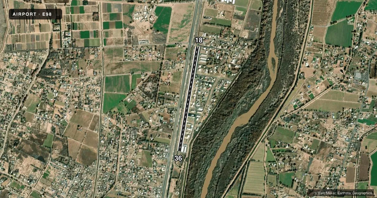
Airport sketch
Runways drawn to scale from FAA survey coordinates, rendered over satellite imagery. Not for navigation.
Approaches & charts
Services on the field
Fuel grades, oxygen, maintenance, ramp storage and lighting — as declared to the FAA by the airport operator.
Fuel & services
- Fuel
- 100LL
- Airframe repair
- Major
- Power plant repair
- Major
- Other services
- CHTR,INSTR,RNTL
Ramp & ground
- Transient storage
- Not published
- Customs
- Not available
- Lighting schedule
- SEE RMK
- Beacon schedule
- SS-SR
- Beacon
- White / Green (civil land)(WG)
- Wind indicator
- Yes
- Segmented circle
- No
Fuel & FBOs
Cheapest 100LL and Jet A on the field and nearby. Always confirm with the FBO before taxi.
Airport notes
Surface conditions, obstructions, local procedures, lighting outages and other notes published with each FAA cycle.
General notes
- RADIO COM REQ.
- RESIDENTIAL; PAEW ON ARPT.
- FOR CD CTC ALBUQUERQUE ARTCC AT 505-856-4861.
Lighting notes
- ACTVT LIRL RWY 18/36 - CTAF.
Fuel notes
- 100LLSELF SVC H24 WITH CREDIT CARD.
Runway surface & condition
- 18/36RWY 36 CALM WIND RWY. 6 FT DITCH 60 FT W; 8 FT RAILROAD 260 FT W & PARL TO RWY.
- 18/36NSTD LIRL; 2 THR LGTS EACH SIDE AT DTHRS.
Approach & departure obstructions
- 18ROAD 46 FT FM THR; +10 FT SIGN 90 FT FM END 125 FT R; +2 FT FENCE 25 FT FM END.
- 36ROAD 50 FT FM RWY END; +2 FT FENCE 35 FT FM RWY END.
- 36PRKD ACFT & BLDGS 65 FT E OF THR OBSTRUCT PRIM SFC.
- 18FADED OR MISG.
- 36FADED OR MISG.
- 18+15 FT ROAD AT END; APCH SLOPE 16:1 BASED ON DTHR.
- 36APCH RATIO 17:1 FM DTHR. BLUE HANGAR 227 FT FM DTHR 85 FT R.
VFR map & nearby airports
VFR sectional. Tap any ICAO chip to open that airport.
Key facts · E98
Answer card- ICAO
- E98
- Name
- MID VALLEY AIRPARK
- Location
- LOS LUNAS, NEW MEXICO
- Elevation
- 4,835.6 ft MSL
- Traffic pattern altitude
- 5,835.6 ft MSL (1,000 AGL)
- Control tower
- Non-towered (use CTAF)
- Total runways
- 1
- Longest runway
- 18/36 · 4,332 ft
- Published ILS approaches
- 0
- Published frequencies
- 1
- Magnetic variation
- 11°
- Current flight rules
- VFR
- Current wind
- 040° at 4 kt
- Favored runway now
- RWY 36
Mid Valley Airpark (E98) sits in Los Lunas, New Mexico. Field elevation is 4,835.6 ft MSL. The airport has one runway, 18/36, which is 4,332 ft long and asphalt. There is no control tower. CTAF is 122.9. No ILS approaches are published here.
Pattern altitude is not published. Use 1,000 ft AGL for light piston operations unless the current FAA Chart Supplement says otherwise. Runway 18/36 has nonstandard low intensity lights. They are activated by radio on CTAF. The field is in a residential area. Radio communication is required. Runway 36 is listed as the calm wind runway.
Hooey, LLC is on the field. It carries AVGAS 100LL. Self-serve 100LL is available 24 hours with a credit card. The runway environment has several published obstructions near both ends, including roads, a fence, a sign, a ditch and a railroad west of the runway. The approach to runway 36 also has parked aircraft and buildings near the threshold. A first-time pilot should plan a careful stabilized approach. Verify the displaced threshold picture. Review the current Chart Supplement before arrival for any operational notes or local restrictions.