METAR & TAF KBRG
Current METAR
Observed 15:55Z
KBRG 221555Z AUTO 04004KT 10SM CLR 26/14 A3027 RMK AO2 T02600140
- Wind
- 040° @ 4 kt
- Visibility
- 10 SM
- Temp / Dew
- 26°C / 14°C
- Altimeter
- 30.27 inHg
- Clouds
- CLR
- Density alt
- 7,333 ft
- Ceiling
- Unlimited
- Rules
- VFR
Airport info & contacts
Manager on record, flight service, ARTCC, attendance schedule and pattern altitude — published by the FAA and refreshed every 28 days.
Location
- From city
- 3 NM W
- VFR sectional
- ALBUQUERQUE
- ARTCC
- ZAB · ALBUQUERQUE
- NOTAM facility
- BRG (NOTAM-D)
Airport manager
- Name
- JOHN THOMPSON
- Phone
- (505) 966-2650
- Address
- 248 SHILOH WAY, BELEN NM 87002
Flight service · Hours
- FSS ABQ
- ALBUQUERQUE1-800-WX-BRIEF
- Attendance
- MON-FRI · 0800-1700
Frequencies
Tap any row to copy the frequency to your clipboard.
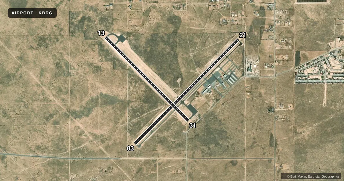
Runways & pattern
Full pagePattern entry · RWY 03
LEFT TRAFFIC| Runway | Heading (°M) | Length | Surface | Traffic |
|---|---|---|---|---|
| 03/21Favored | 34° / 214° | 6,601 ft | ASPH | 21 R |
| 13/31 | 124° / 304° | 5,280 ft | ASPH | 13 R |
Runway end performance
| End | TORA | TODA | ASDA | LDA | VGSI | Approach lights | Obstruction |
|---|---|---|---|---|---|---|---|
| 21 | — | — | — | — | PSIL(3°) | — | — |
Declared distances in feet. TORA = takeoff run available, TODA = takeoff distance, ASDA = accelerate-stop, LDA = landing distance.
Airport sketch
Runways drawn to scale from FAA survey coordinates, rendered over satellite imagery. Not for navigation.
Approaches & charts
Services on the field
Fuel grades, oxygen, maintenance, ramp storage and lighting — as declared to the FAA by the airport operator.
Fuel & services
- Fuel
- 100LLA1+
- Airframe repair
- Major
- Power plant repair
- Major
- Other services
- PAJA,SURV
Ramp & ground
- Transient storage
- Tie-down
- Hangar
- Landing fee
- No fee published
- Customs
- Not available
- Lighting schedule
- SEE RMK
- Beacon schedule
- SS-SR
- Beacon
- White / Green (civil land)(WG)
- Wind indicator
- Lighted
- Segmented circle
- Yes
Fuel & FBOs
Cheapest 100LL and Jet A on the field and nearby. Always confirm with the FBO before taxi.
Airport notes
Surface conditions, obstructions, local procedures, lighting outages and other notes published with each FAA cycle.
General notes
- MIL TRNG H24; RADIO RQRD.
- FOR CD CTC ALBUQUERQUE ARTCC AT 505-856-4861.
Lighting notes
- ACTVT PVASI RWY 21; MIRL RWY 03/21 - CTAF.
Fuel notes
- 100LLAFT HR FULL SVC JET A - AMGR. 100LL & JET A SELF SVC H24 WITH CREDIT CARD.
Runway surface & condition
- 13/31OVR 160000 LB NA. 4-8 IN DROP ALG N EDGE.
Approach & departure obstructions
- 03+2 FT DIRT BERM 90 FT L & R CNTRLN 60-200 FT FM THR.
Other notes
- AVBLTY - AMGR.
VFR map & nearby airports
VFR sectional. Tap any ICAO chip to open that airport.
Key facts · KBRG
Answer card- ICAO
- KBRG
- Name
- BELEN RGNL
- Location
- BELEN, NEW MEXICO
- Elevation
- 5,199.5 ft MSL
- Traffic pattern altitude
- 6,199.5 ft MSL (1,000 AGL)
- Control tower
- Non-towered (use CTAF)
- Total runways
- 2
- Longest runway
- 03/21 · 6,601 ft
- Published ILS approaches
- 0
- Published frequencies
- 4
- Magnetic variation
- 11°
- Current flight rules
- VFR
- Current wind
- 040° at 4 kt
- Favored runway now
- RWY 03
Belen Rgnl is in Belen, New Mexico. The field elevation is 5,199.5 ft MSL. It has two asphalt runways. The longest is 6,601 ft on runway 03/21. This is a non-towered field. No ILS approaches are published here. The published pattern altitude is not listed, so use the current Chart Supplement before you fly. For light piston traffic, standard pattern planning is 1,000 ft AGL unless the current published data says otherwise.
The on-field FBO is Belen Regional Airport. It carries 100LL and Jet A Prist. The remarks also note 24-hour self-service fuel with a credit card. After hours, full service Jet A is available through the airport manager. Military training is conducted around the clock, so expect active traffic and keep the radio on. Clearance delivery goes through Albuquerque ARTCC. Runway 21 has a precision visual glide path indicator. Medium intensity runway lights on 03 and 21 are controlled by CTAF. There is also a dirt berm near runway 03, 90 ft left and right of centerline from 60 to 200 ft from the threshold. Runway 13/31 has a 4 to 8 inch drop along the north edge. Pilots should verify current airport status with the airport manager if needed.