METAR & TAF KONM
Current METAR
Observed 17:15Z
KONM 271715Z AUTO 36008G15KT 10SM CLR 35/11 A3012 RMK AO2 T03510108
- Wind
- 360° @ 8G15 kt
- Visibility
- 10 SM
- Temp / Dew
- 35°C / 11°C
- Altimeter
- 30.12 inHg
- Clouds
- CLR
- Density alt
- 8,197 ft
- Ceiling
- Unlimited
- Rules
- VFR
Airport info & contacts
Manager on record, flight service, ARTCC, attendance schedule and pattern altitude — published by the FAA and refreshed every 28 days.
Location
- From city
- 3 NM S
- VFR sectional
- ALBUQUERQUE
- ARTCC
- ZAB · ALBUQUERQUE
- NOTAM facility
- ABQ (NOTAM-D)
Airport manager
- Name
- ISAAC ANGEL
- Phone
- 505-507-2800
- Address
- PO BOX K, SOCORRO NM 87801
Flight service · Hours
- FSS ABQ
- ALBUQUERQUE1-800-WX-BRIEF
- Attendance
- Unattended
Frequencies
Tap any row to copy the frequency to your clipboard.
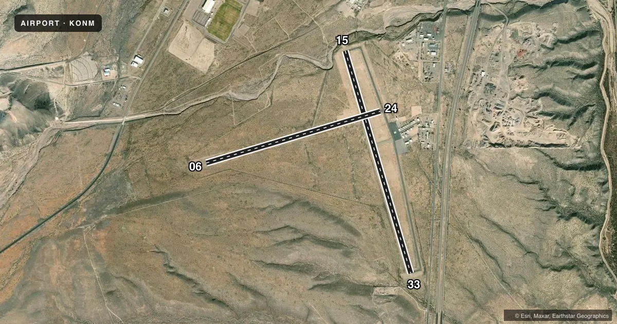
Runways & pattern
Full pagePattern entry · RWY 33
LEFT TRAFFIC| Runway | Heading (°M) | Length | Surface | Traffic |
|---|---|---|---|---|
| 15/33Favored | 155° / 335° | 5,841 ft | ASPH | Standard L |
| 06/24 | 65° / 245° | 4,590 ft | ASPH | Standard L |
Runway end performance
| End | TORA | TODA | ASDA | LDA | VGSI | Approach lights | Obstruction |
|---|---|---|---|---|---|---|---|
| 15 | — | — | — | — | PAPI 2-box left(4°) | — | — |
| 33 | — | — | — | — | PAPI 2-box left(4°) | — | — |
Declared distances in feet. TORA = takeoff run available, TODA = takeoff distance, ASDA = accelerate-stop, LDA = landing distance.
Airport sketch
Runways drawn to scale from FAA survey coordinates, rendered over satellite imagery. Not for navigation.
Approaches & charts
Services on the field
Fuel grades, oxygen, maintenance, ramp storage and lighting — as declared to the FAA by the airport operator.
Fuel & services
- Fuel
- 100LL
Ramp & ground
- Transient storage
- Tie-down
- Hangar
- Landing fee
- No fee published
- Customs
- Not available
- Lighting schedule
- SEE RMK
- Beacon schedule
- SS-SR
- Beacon
- White / Green (civil land)(WG)
- Wind indicator
- Lighted
- Segmented circle
- Yes
Fuel & FBOs
Cheapest 100LL and Jet A on the field and nearby. Always confirm with the FBO before taxi.
Airport notes
Surface conditions, obstructions, local procedures, lighting outages and other notes published with each FAA cycle.
General notes
- GATE CODE 4850.
- FOR CD CTC ALBUQUERQUE ARTCC AT 505-856-4561.
- RY 06/24 4-8 FT SCATTERED BRUSH IN PRI SFC 80 FT TO 125 FTFM CNTRLN SOUTH SIDE; 60 TO 125 FT FRM CENTERLINE NORTH SIDE, WEST OF INTXN.
- RY 15/33 4-7 FT BRUSH IN PRI SFC 70 FT -250 FT FM CNTRLN WEST SIDE, SOUTH OF RWY 06/24, 1 FT TO 2 FT BRUSH 100 FT TO 200 FT FM CNTRLN EAST SIDE OF RWY.
Lighting notes
- ACTVT PAPI RWY 15; PAPI RWY 33; MIRL RWY 06/24 & 15/33 - CTAF. MIRL RWY 15/33 PRESET LOW INTST; INCR INTST - CTAF.
Fuel notes
- 100LLAVBL H24 WITH CREDIT CARD.
Runway surface & condition
- 06/244-8 FT BRUSH IN PRIM SFC 50-125 FT FM CNTRLN S SIDE & 60-125 FT FM CNTRLN N SIDE.
- 15/33+4-7 FT BRUSH IN PRIM SFC 70-250 FT FM CNTRLN W SIDE & S OF RWY 06/24.
Approach & departure obstructions
- 151-3FT BRUSH 20-80 FT FM THR BOTH SIDES; 3 FT FENCE 80 FT FM THR 60 FT L OF CNTRLN.
- 15-40 FT DROP OFF 175 FT FM THR BOTH SIDES.
- 33-20 FT DROP OFF 100 FT FM THR BOTH SIDES.
- 1550:1 TO DTHR.
- 330:1 TO DTHR DUE TO 3-4 FT BRUSH 120-250 FT L OF CNTRLN AT DTHR.
Other notes
- THIS AIRPORT HAS BEEN SURVEYED BY THE NATIONAL GEODETIC SURVEY.
- CALL AMGR FOR AVBLTY.
- 1EMERG - 505-507-2800.
VFR map & nearby airports
VFR sectional. Tap any ICAO chip to open that airport.
Key facts · KONM
Answer card- ICAO
- KONM
- Name
- SOCORRO MUNI
- Location
- SOCORRO, NEW MEXICO
- Elevation
- 4,875.2 ft MSL
- Traffic pattern altitude
- 5,875.2 ft MSL (1,000 AGL)
- Control tower
- Non-towered (use CTAF)
- Total runways
- 2
- Longest runway
- 15/33 · 5,841 ft
- Published ILS approaches
- 0
- Published frequencies
- 2
- Magnetic variation
- 9°
- Current flight rules
- VFR
- Current wind
- 360° at 8 kt
- Favored runway now
- RWY 33
Socorro Muni sits in Socorro, New Mexico. Field elevation is 4,875.2 ft MSL. The airport has two asphalt runways. The longest is 5,841 ft on runway 15/33. Runway 06/24 is 4,590 ft. There is no control tower. CTAF and UNICOM are both 122.8.
No ILS approaches are published here. Pattern altitude is not published, so use the standard 1,000 ft AGL for light piston operations unless the current FAA Chart Supplement says otherwise. That puts the traffic pattern at about 5,875 ft MSL. The on-field FBO is Socorro Municipal Airport. It carries 100LL. Remarks say 100LL is available 24 hours with credit card. The field has medium intensity runway lights on both runways. PAPI is active on runways 15 and 33.
First-time pilots should pay close attention to the published brush and terrain notes. There is brush near the primary surface on runway 06/24. Runway 33 has a zero to one obstacle clearance slope at the departure end because of brush near the centerline. Runway 33 also has a drop-off near the threshold. This is a high-elevation field in central New Mexico, so expect density altitude to matter. Check the current FAA Chart Supplement for any updated operational notes before you go.