METAR & TAF KTCS
Current METAR
Observed 16:53Z
KTCS 271653Z AUTO 00000KT 10SM CLR 33/13 A3012 RMK AO2 SLP093 T03330133 $
- Wind
- 000° @ 0 kt
- Visibility
- 10 SM
- Temp / Dew
- 33°C / 13°C
- Altimeter
- 30.12 inHg
- Clouds
- CLR
- Density alt
- 7,941 ft
- Ceiling
- Unlimited
- Rules
- VFR
Airport info & contacts
Manager on record, flight service, ARTCC, attendance schedule and pattern altitude — published by the FAA and refreshed every 28 days.
Location
- From city
- 6 NM N
- VFR sectional
- ALBUQUERQUE
- ARTCC
- ZAB · ALBUQUERQUE
- NOTAM facility
- TCS (NOTAM-D)
Airport manager
- Name
- CHAD ROSACKER
- Phone
- 575-894-6199
- Address
- 505 SIMS, TRUTH OR CONSEQUENCE NM 87901
Flight service · Hours
- FSS ABQ
- ALBUQUERQUE1-800-WX-BRIEF
- Attendance
- 0800-1600
Frequencies
Tap any row to copy the frequency to your clipboard.
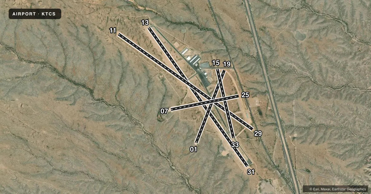
Runways & pattern
Full pagePattern entry · RWY 13
LEFT TRAFFIC| Runway | Heading (°M) | Length | Surface | Traffic |
|---|---|---|---|---|
| 13/31 | 132° / 312° | 7,202 ft | ASPH | Standard L |
| 11/29 | 112° / 292° | 6,981 ft | GRVL | Standard L |
| 01/19 | 8° / 188° | 3,302 ft | GRVL | Standard L |
| 15/33 | 154° / 334° | 3,001 ft | GRVL | Standard L |
| 07/25 | 66° / 246° | 2,933 ft | GRVL | Standard L |
Runway end performance
| End | TORA | TODA | ASDA | LDA | VGSI | Approach lights | Obstruction |
|---|---|---|---|---|---|---|---|
| 13 | — | — | — | — | PAPI 2-box left(3°) | — | — |
| 31 | — | — | — | — | PAPI 2-box left(3°) | — | — |
| 11 | — | — | — | — | — | — | 4', fence, 0' from thr, 0' R of cntrln, slope 0 |
| 29 | — | — | — | — | — | — | 6', brush, 0' from thr, 0' R of cntrln, slope 0 |
| 19 | — | — | — | — | — | — | 15', road, 90' from thr, 0' R of cntrln, slope 6 |
| 15 | — | — | — | — | — | — | 15', road, 45' from thr, 0' R of cntrln, slope 3 |
| 25 | — | — | — | — | — | — | 10', road, 0' from thr, 0' R of cntrln, slope 0 |
Declared distances in feet. TORA = takeoff run available, TODA = takeoff distance, ASDA = accelerate-stop, LDA = landing distance.
Airport sketch
Runways drawn to scale from FAA survey coordinates, rendered over satellite imagery. Not for navigation.
Approaches & charts
Services on the field
Fuel grades, oxygen, maintenance, ramp storage and lighting — as declared to the FAA by the airport operator.
Fuel & services
- Fuel
- 100LLA1+
Ramp & ground
- Transient storage
- Tie-down
- Hangar
- Landing fee
- No fee published
- Customs
- Not available
- Lighting schedule
- SEE RMK
- Beacon schedule
- SS-SR
- Beacon
- White / Green (civil land)(WG)
- Wind indicator
- Lighted
- Segmented circle
- No
Fuel & FBOs
Cheapest 100LL and Jet A on the field and nearby. Always confirm with the FBO before taxi.
Airport notes
Surface conditions, obstructions, local procedures, lighting outages and other notes published with each FAA cycle.
General notes
- ULTRALIGHT OPS WI 5 NM.
- 1 FT GRAVEL BERMS ALG EDGES OF ALL GRAVEL RYS.
- FOR CD IF UNA TO CTC ON FSS FREQ, CTC ALBUQUERQUE ARTCC AT 505-856-4561.
- FUEL AFT HR - AMGR.
Lighting notes
- DUSK-DAWN: ACTVT MIRL RWY 13/31 - CTAF.
Approach & departure obstructions
- 01SHARP DROP OFFS APCH END.
- 07SHARP DROP OFFS APCH END.
- 11CTLG OBSTN EXCEEDS 45 DEG SLOPE.
Other notes
- AVBLTY - AMGR.
VFR map & nearby airports
VFR sectional. Tap any ICAO chip to open that airport.
Key facts · KTCS
Answer card- ICAO
- KTCS
- Name
- TRUTH OR CONSEQUENCES MUNI
- Location
- TRUTH OR CONSEQUENCES, NEW MEXICO
- Elevation
- 4,861.9 ft MSL
- Traffic pattern altitude
- 5,861.9 ft MSL (1,000 AGL)
- Control tower
- Non-towered (use CTAF)
- Total runways
- 5
- Longest runway
- 13/31 · 7,202 ft
- Published ILS approaches
- 0
- Published frequencies
- 2
- Magnetic variation
- 13°
- Current flight rules
- VFR
- Current wind
- 000° at 0 kt
- Favored runway now
- –
Truth or Consequences Muni sits in Truth or Consequences, New Mexico. The field elevation is 4,861.9 ft MSL. It has five runways. The longest is runway 13/31 at 7,202 ft. There is no control tower. CTAF and UNICOM are both 122.8. No ILS approaches are published.
Pattern altitude is not published. Use a standard 1,000 ft AGL pattern for light piston operations unless the current Chart Supplement says otherwise. That puts the pattern near 5,861.9 ft MSL based on the field elevation. The on-field FBO is Truth or Consequences Municipal Airport. It carries 100LL and Jet A. Call ahead at (575) 894-6199 for current service details.
This is a high-elevation field, so performance planning matters. The published remarks also call out ultralight activity within 5 NM. Runway 13/31 has medium intensity lights that are activated by CTAF from dusk to dawn. Be careful on the gravel runways. Runway 07/25 has brush and rough areas. Runway 01 has sharp drop-offs at the approach end. Runway 07 has sharp drop-offs too. Cataloged obstacles at runway 07 exceed a 45 degree slope. Operations between runways are not visible because of brush. Check the current FAA Chart Supplement before departure for the latest runway and operational notes.