METAR & TAF KSVC
Current METAR
Observed 16:55Z
KSVC 271655Z AUTO 28004KT 10SM CLR 33/12 A3019 RMK AO2 T03280119
- Wind
- 280° @ 4 kt
- Visibility
- 10 SM
- Temp / Dew
- 33°C / 12°C
- Altimeter
- 30.19 inHg
- Clouds
- CLR
- Density alt
- 8,578 ft
- Ceiling
- Unlimited
- Rules
- VFR
Airport info & contacts
Manager on record, flight service, ARTCC, attendance schedule and pattern altitude — published by the FAA and refreshed every 28 days.
Location
- From city
- 10 NM SE
- VFR sectional
- ALBUQUERQUE
- ARTCC
- ZAB · ALBUQUERQUE
- NOTAM facility
- SVC (NOTAM-D)
Airport manager
- Name
- REBEKAH WENGER
- Phone
- 575-313-9784
- Address
- PO BOX 6 182 AIRPORT ROAD, HURLEY NM 88043
Flight service · Hours
- FSS ABQ
- ALBUQUERQUE1-800-WX-BRIEF
- Attendance
- 0600-1700
Frequencies
Tap any row to copy the frequency to your clipboard.
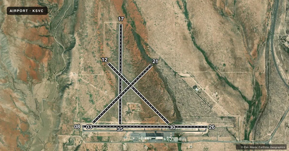
Runways & pattern
Full pagePattern entry · RWY 26
LEFT TRAFFIC| Runway | Heading (°M) | Length | Surface | Traffic |
|---|---|---|---|---|
| 08/26Favored | 82° / 262° | 6,803 ft | ASPH | Standard L |
| 17/35 | 172° / 352° | 5,473 ft | DIRT | Standard L |
| 12/30 | 127° / 307° | 4,675 ft | DIRT | Standard L |
| 03/21 | 37° / 217° | 4,537 ft | DIRT | Standard L |
Runway end performance
| End | TORA | TODA | ASDA | LDA | VGSI | Approach lights | Obstruction |
|---|---|---|---|---|---|---|---|
| 08 | — | — | — | — | PAPI 4-box left(3°) | — | — |
| 26 | — | — | — | — | PAPI 4-box left(3°) | MALS | — |
| 17 | — | — | — | — | — | — | 6', fence, 0' from thr, 0' R of cntrln, slope 0 |
| 35 | — | — | — | — | — | — | 35', pline, 1000' from thr, 0' R of cntrln, slope 28 |
| 12 | — | — | — | — | — | — | 5', fence, 100' from thr, 0' R of cntrln, slope 20 |
| 30 | — | — | — | — | — | — | 30', tower, 800' from thr, 100' R of cntrln, slope 26 |
| 03 | — | — | — | — | — | — | 35', pole, 800' from thr, 250' R of cntrln, slope 22 |
| 21 | — | — | — | — | — | — | 4', fence, 0' from thr, 0' R of cntrln, slope 0 |
Declared distances in feet. TORA = takeoff run available, TODA = takeoff distance, ASDA = accelerate-stop, LDA = landing distance.
Airport sketch
Runways drawn to scale from FAA survey coordinates, rendered over satellite imagery. Not for navigation.
Approaches & charts
ILS · 1
Services on the field
Fuel grades, oxygen, maintenance, ramp storage and lighting — as declared to the FAA by the airport operator.
Fuel & services
- Fuel
- 100LLA1
- Other services
- CHTR
Ramp & ground
- Transient storage
- Tie-down
- Landing fee
- No fee published
- Customs
- Not available
- Lighting schedule
- SEE RMK
- Beacon schedule
- SS-SR
- Beacon
- White / Green (civil land)(WG)
- Wind indicator
- Lighted
- Segmented circle
- Yes
Fuel & FBOs
Cheapest 100LL and Jet A on the field and nearby. Always confirm with the FBO before taxi.
Airport notes
Surface conditions, obstructions, local procedures, lighting outages and other notes published with each FAA cycle.
General notes
- 5621 FT CRANE NE OF ARPT 8800 FT FM RWY 26 ON CNTRLN.
- FOR CD IF UNA TO CTC ON FSS FREQ, CTC ALBUQUERQUE ARTCC AT 505-856-4561.
- TWY A2, A3 & A4 UNUSBL COCKPIT TO MAIN GEAR LEN OVR 40 FT.
Lighting notes
- ACTVT MALS RWY 26; REIL RWY 08; MIRL RWY 08/26 - CTAF.
Runway surface & condition
- 08/26PCR VALUE: 230/F/C/X/T
- 03/21DALGT VFR COND ONLY.
- 12/30DALGT VFR COND ONLY.
- 17/35DALGT VFR COND ONLY.
Approach & departure obstructions
- 17DTHR MKD BY TIRES.
- 0839 INCHES TALL LOCTD 9 FT FM THE EDGE OF TWY A5.
- 17APCH RATIO 16:1 FM DTHR.
VFR map & nearby airports
VFR sectional. Tap any ICAO chip to open that airport.
Key facts · KSVC
Answer card- ICAO
- KSVC
- Name
- GRANT COUNTY
- Location
- SILVER CITY, NEW MEXICO
- Elevation
- 5,445.6 ft MSL
- Traffic pattern altitude
- 6,445.6 ft MSL (1,000 AGL)
- Control tower
- Non-towered (use CTAF)
- Total runways
- 4
- Longest runway
- 08/26 · 6,803 ft
- Published ILS approaches
- 1
- Published frequencies
- 2
- Magnetic variation
- 8°
- Current flight rules
- VFR
- Current wind
- 280° at 4 kt
- Favored runway now
- RWY 26
Grant County Airport sits in Silver City, New Mexico. The field elevation is 5,445.6 ft MSL. It has four runways. The longest is runway 08/26 at 6,803 ft. There is no control tower, so plan on CTAF and UNICOM 122.8 for local traffic. The airport has one ILS approach to runway 26. Pattern altitude is not published, so use standard 1,000 ft AGL for light piston unless the current Chart Supplement says otherwise.
Grant County Airport is high enough that density altitude can matter on warm days. Performance planning should be part of the brief. The on-field FBO is Grant County Airport. It carries 100LL and Jet A. Call (575) 388-4554 for current service status before you go. Published remarks also note that runway 26 has medium intensity approach lighting with sequenced flashing lights. Runway 08 has runway end identifier lights. Runway lights on 08 and 26 are tied to CTAF control. A crane is published northeast of the airport on the runway 26 centerline, so keep that in mind on arrival and departure. Taxiways A2, A3 and A4 are unusable for aircraft with a cockpit to main gear length over 40 ft.