METAR & TAF KDMN
Current METAR
Observed 18:53Z
KDMN 271853Z AUTO 29003KT 10SM CLR 38/14 A3006 RMK AO2 SLP083 T03780139
- Wind
- 290° @ 3 kt
- Visibility
- 10 SM
- Temp / Dew
- 38°C / 14°C
- Altimeter
- 30.06 inHg
- Clouds
- CLR
- Density alt
- 7,936 ft
- Ceiling
- Unlimited
- Rules
- VFR
Airport info & contacts
Manager on record, flight service, ARTCC, attendance schedule and pattern altitude — published by the FAA and refreshed every 28 days.
Location
- From city
- 2 NM SE
- VFR sectional
- ALBUQUERQUE
- ARTCC
- ZAB · ALBUQUERQUE
- NOTAM facility
- DMN (NOTAM-D)
Airport manager
- Name
- AZUCENA VARGAS
- Phone
- 575-546-8848
- Address
- 1275 E. PINE ST, DEMING NM 88030
Flight service · Hours
- FSS ABQ
- ALBUQUERQUE1-800-WX-BRIEF
- Attendance
- 0700-1800
Frequencies
Tap any row to copy the frequency to your clipboard.
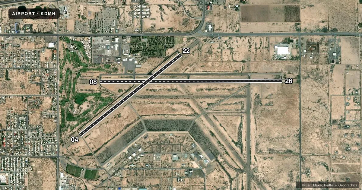
Runways & pattern
Full pagePattern entry · RWY 26
LEFT TRAFFIC| Runway | Heading (°M) | Length | Surface | Traffic |
|---|---|---|---|---|
| 08/26Favored | 80° / 260° | 8,018 ft | ASPH | Standard L |
| 04/22 | 42° / 222° | 5,675 ft | ASPH | Standard L |
Runway end performance
| End | TORA | TODA | ASDA | LDA | VGSI | Approach lights | Obstruction |
|---|---|---|---|---|---|---|---|
| 08 | — | — | — | — | PAPI 4-box left(3°) | — | 10', brush, 260' from thr, 75' R of cntrln, slope 6 |
| 26 | — | — | — | — | PAPI 4-box left(3°) | — | — |
| 04 | — | — | — | — | PAPI 2-box left(3°) | — | 8', brush, 340' from thr, 70' R of cntrln, slope 17 |
| 22 | — | — | — | — | PAPI 2-box left(3°) | — | 8', brush, 200' from thr, 75' R of cntrln, slope 0 |
Declared distances in feet. TORA = takeoff run available, TODA = takeoff distance, ASDA = accelerate-stop, LDA = landing distance.
Airport sketch
Runways drawn to scale from FAA survey coordinates, rendered over satellite imagery. Not for navigation.
Approaches & charts
Services on the field
Fuel grades, oxygen, maintenance, ramp storage and lighting — as declared to the FAA by the airport operator.
Fuel & services
- Fuel
- 100LLA1+
- Other services
- AMB
Ramp & ground
- Transient storage
- Tie-down
- Hangar
- Landing fee
- No fee published
- Customs
- Not available
- Lighting schedule
- SEE RMK
- Beacon schedule
- SS-SR
- Beacon
- White / Green (civil land)(WG)
- Wind indicator
- Lighted
- Segmented circle
- No
Fuel & FBOs
Cheapest 100LL and Jet A on the field and nearby. Always confirm with the FBO before taxi.
Airport notes
Surface conditions, obstructions, local procedures, lighting outages and other notes published with each FAA cycle.
General notes
- HEL ARR & DEP E; RMN N OF SEGMENTED CIRCLE.
- INTXN TKOF NA.
- FOR CD IF UNA TO CTC ON FSS FREQ, CTC ALBUQUERQUE ARTCC AT 505-856-4561.
Lighting notes
- ACTVT PAPI RWY 04, 08, 22, 26; MIRL RWY 08/26 - CTAF. 1730-2230 PAPI RWY 04, 08, 22, 26; MIRL RWY 08/26 PRESET LOW INTST; INCR INTST - CTAF.
Approach & departure obstructions
- 045 FT BRUSH 100-160 FT FM THR 70 FT LEFT & RIGHT OF CNTRLN.
- 083 FT TO 4 FT BRUSH 65 FT FM THR, 3 FT TO 8 FT BRUSH 80 FT FM THR 75 FT LEFT OF CNTRLN.
- 22+3-8 FT BRUSH 60-200 FT FM THR 75 FT R & L OF CNTRLN.
- 266 FT BRUSH 160 FT. FM THR, 110 FT. RIGHT OF CNTRLN.
- 04CONTROLLING OBSTN EXCEEDS A 45 DEG SLOPE.
Other notes
- 1AFT HR - 575-494-2311.
- MANAGER575-494-2311 ALTERNATE
VFR map & nearby airports
VFR sectional. Tap any ICAO chip to open that airport.
Key facts · KDMN
Answer card- ICAO
- KDMN
- Name
- DEMING MUNI
- Location
- DEMING, NEW MEXICO
- Elevation
- 4,314 ft MSL
- Traffic pattern altitude
- 5,314 ft MSL (1,000 AGL)
- Control tower
- Non-towered (use CTAF)
- Total runways
- 2
- Longest runway
- 08/26 · 8,018 ft
- Published ILS approaches
- 0
- Published frequencies
- 2
- Magnetic variation
- 10°
- Current flight rules
- VFR
- Current wind
- 290° at 3 kt
- Favored runway now
- RWY 26
Deming Muni is in Deming, New Mexico. The field elevation is 4,314 ft MSL. It has two asphalt runways. The longest is 8,018 ft on runway 08/26. There is no control tower. CTAF and UNICOM are both 122.8. No ILS approaches are published, so plan for non-precision work or visual operations as conditions allow.
Pattern altitude is not published. Use the standard 1,000 ft AGL pattern for light piston traffic unless local procedures or ATC say otherwise. Desert Aviation is on the field. It carries 100LL and Jet A. If you need current ramp or fuel details, call them at (575) 544-3660.
A few published remarks matter here. Helicopter traffic arrives and departs to the east. Stay north of the segmented circle. Runway 04 has a 5-foot brush obstruction near the threshold on the left side. Runway 22 has brush 3 to 8 feet high near the threshold on both sides of the centerline. Intersection takeoffs are not authorized. Lighting is useful after sunset. PAPI is available for runways 04, 08, 22 and 26. Medium intensity runway lights are available on 08 and 26 and are keyed on CTAF. From 1730 to 2230, the lights and PAPIs are preset to low intensity. Deming sits in open high-desert country. Expect performance to reflect the elevation.