METAR & TAF KLSB
Current METAR
Observed 19:35Z
KLSB 271935Z AUTO 30014G25KT 10SM CLR 38/12 A3007 RMK AO2
- Wind
- 300° @ 14G25 kt
- Visibility
- 10 SM
- Temp / Dew
- 38°C / 12°C
- Altimeter
- 30.07 inHg
- Clouds
- CLR
- Density alt
- 7,891 ft
- Ceiling
- Unlimited
- Rules
- VFR
Airport info & contacts
Manager on record, flight service, ARTCC, attendance schedule and pattern altitude — published by the FAA and refreshed every 28 days.
Location
- From city
- 1 NM SE
- VFR sectional
- ALBUQUERQUE
- ARTCC
- ZAB · ALBUQUERQUE
- NOTAM facility
- ABQ (NOTAM-D)
Airport manager
- Name
- FRITZ PLACENCIA
- Phone
- 575-542-3614
- Address
- 1000 AIRPORT ROAD, LORDSBURG NM 88045
Flight service · Hours
- FSS ABQ
- ALBUQUERQUE1-800-WX-BRIEF
- Attendance
- 0800-1700
Frequencies
Tap any row to copy the frequency to your clipboard.
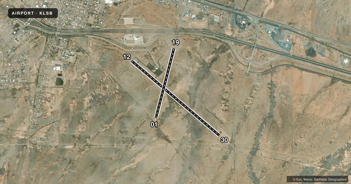
Runways & pattern
Full pagePattern entry · RWY 30
LEFT TRAFFIC| Runway | Heading (°M) | Length | Surface | Traffic |
|---|---|---|---|---|
| 12/30Favored | 119° / 299° | 5,224 ft | ASPH | Standard L |
| 01/19 | 4° / 184° | 3,251 ft | DIRT | Standard L |
Runway end performance
| End | TORA | TODA | ASDA | LDA | VGSI | Approach lights | Obstruction |
|---|---|---|---|---|---|---|---|
| 30 | — | — | — | — | — | — | 3', brush, 200' from thr, 70' R of cntrln, slope 0 |
| 01 | — | — | — | — | — | — | 3', brush, 0' from thr, 50' R of cntrln, slope 0 |
| 19 | — | — | — | — | — | — | 3', brush, 30' from thr, 55' R of cntrln, slope 10 |
Declared distances in feet. TORA = takeoff run available, TODA = takeoff distance, ASDA = accelerate-stop, LDA = landing distance.
Airport sketch
Runways drawn to scale from FAA survey coordinates, rendered over satellite imagery. Not for navigation.
Approaches & charts
Services on the field
Fuel grades, oxygen, maintenance, ramp storage and lighting — as declared to the FAA by the airport operator.
Fuel & services
- Fuel
- 100LLA1+
- Oxygen (bottled)
- Not available
- Oxygen (bulk)
- Not available
Ramp & ground
- Transient storage
- Tie-down
- Hangar
- Landing fee
- No fee published
- Customs
- Not available
- Lighting schedule
- SEE RMK
- Beacon schedule
- SS-SR
- Beacon
- White / Green (civil land)(WG)
- Wind indicator
- Lighted
- Segmented circle
- Yes
Fuel & FBOs
Cheapest 100LL and Jet A on the field and nearby. Always confirm with the FBO before taxi.
Airport notes
Surface conditions, obstructions, local procedures, lighting outages and other notes published with each FAA cycle.
General notes
- FOR CD CTC ALBUQUERQUE ARTCC AT 505-856-4861.
- RWY 01/19 THR MARKED WITH REFLECTORS & PAINTED TIRES.
- RWY 12/30, 2-4 FT BRUSH, 75-125 FT SOUTH OF CNTRLN. 2-3 FT SCATTERED BRUSH, 60-125 FT NORTH OF CNTRLN IN PRIMARY SURFACE.
Lighting notes
- ACTVT MIRL RY 12/30 - CTAF.
Fuel notes
- 100LL24 HRS SELF SERVE FUEL WITH MAJOR CREDIT CARD.
Approach & departure obstructions
- 302 FT BRUSH IN 30 FT-200 FT FM THR ACRS APCH.
- 01CONTROLLING OBSTRUCTION EXCEEDS A 45 DEGREE SLOPE
Other notes
- CALL AHEAD FOR HANGAR AVAILABILITY 575-542-3614.
- MANAGERALT. PHONE: 575-519-2356.
- 01/19RWY 1-19 ROUGH SOUTH OF RWY 12-30.
VFR map & nearby airports
VFR sectional. Tap any ICAO chip to open that airport.
Key facts · KLSB
Answer card- ICAO
- KLSB
- Name
- LORDSBURG MUNI
- Location
- LORDSBURG, NEW MEXICO
- Elevation
- 4,287.9 ft MSL
- Traffic pattern altitude
- 5,287.9 ft MSL (1,000 AGL)
- Control tower
- Non-towered (use CTAF)
- Total runways
- 2
- Longest runway
- 12/30 · 5,224 ft
- Published ILS approaches
- 0
- Published frequencies
- 2
- Magnetic variation
- 11°
- Current flight rules
- VFR
- Current wind
- 300° at 14 kt
- Favored runway now
- RWY 30
Lordsburg Muni sits in Lordsburg, New Mexico. Field elevation is 4,287.9 ft MSL. The airport has two runways. The longest is 12/30 at 5,224 ft. Runway 01/19 is 3,251 ft and dirt. This is an untowered field. CTAF and UNICOM are both 122.8. No ILS approaches are published.
The pattern altitude is not published. Use the standard 1,000 ft AGL for light piston ops unless the current Chart Supplement says otherwise. The on-field FBO is Lordsburg Municipal Airport. It carries 100LL and Jet A. Twenty-four hour self-serve 100LL is available with a major credit card. Call ahead at 575-542-3614 if you need hangar space. The airport also lists alternate manager numbers.
For a first-time arrival, pay attention to the terrain and the field elevation. Density altitude can be a factor here. Runway 12/30 has brush near the runway environment. There is also brush near the approach end of runway 30. Runway 01/19 has a marked threshold with reflectors and painted tires. Medium intensity runway lights on 12/30 are activated on CTAF. Clearance delivery is handled through Albuquerque ARTCC. Check the current Chart Supplement for any additional local procedures before you go.