METAR & TAF P33
Current METAR
Observed 12:56Z
KP33 271256Z AUTO 00000KT 10SM CLR 21/19 A3012 RMK AO2
- Wind
- 000° @ 0 kt
- Visibility
- 10 SM
- Temp / Dew
- 21°C / 19°C
- Altimeter
- 30.12 inHg
- Clouds
- CLR
- Density alt
- 5,664 ft
- Ceiling
- Unlimited
- Rules
- VFR
Airport info & contacts
Manager on record, flight service, ARTCC, attendance schedule and pattern altitude — published by the FAA and refreshed every 28 days.
Location
- From city
- 3 NM W
- VFR sectional
- PHOENIX
- ARTCC
- ZAB · ALBUQUERQUE
- NOTAM facility
- PRC (NOTAM-D)
Airport manager
- Name
- MIKE WEAR
- Phone
- (520) 384-2908
- Address
- 780 S VISTA AVE, WILCOX AZ 85643
Flight service · Hours
- FSS PRC
- PRESCOTT1-800-WX-BRIEF
- Attendance
- 0800-1700, CLSD HOLS
Frequencies
Tap any row to copy the frequency to your clipboard.
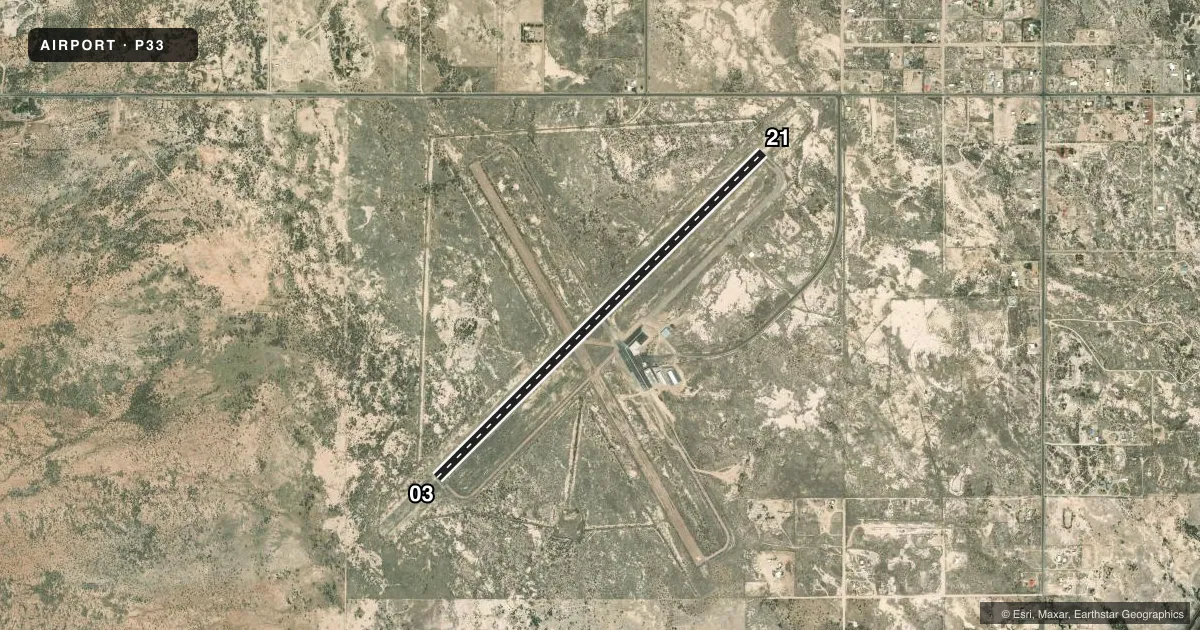
Runways & pattern
Full pagePattern entry · RWY 03
LEFT TRAFFICRunway end performance
| End | TORA | TODA | ASDA | LDA | VGSI | Approach lights | Obstruction |
|---|---|---|---|---|---|---|---|
| 03 | — | — | — | — | PAPI 4-box left(3°) | — | — |
| 21 | — | — | — | — | PAPI 4-box left(3°) | — | — |
Declared distances in feet. TORA = takeoff run available, TODA = takeoff distance, ASDA = accelerate-stop, LDA = landing distance.
Airport sketch
Runways drawn to scale from FAA survey coordinates, rendered over satellite imagery. Not for navigation.
Approaches & charts
Services on the field
Fuel grades, oxygen, maintenance, ramp storage and lighting — as declared to the FAA by the airport operator.
Fuel & services
- Fuel
- 100LLA1+
- Airframe repair
- Minor
- Power plant repair
- Minor
- Other services
- INSTR,RNTL
Ramp & ground
- Transient storage
- Tie-down
- Hangar
- Landing fee
- No fee published
- Customs
- Not available
- Lighting schedule
- SEE RMK
- Beacon schedule
- SS-SR
- Beacon
- White / Green (civil land)(WG)
- Wind indicator
- Lighted
- Segmented circle
- Yes
Fuel & FBOs
Cheapest 100LL and Jet A on the field and nearby. Always confirm with the FBO before taxi.
Airport notes
Surface conditions, obstructions, local procedures, lighting outages and other notes published with each FAA cycle.
General notes
- MIL OPS INVOF ARPT.
- S HALF OF PARL TWY CLSD.
- FOR CD CTC ALBUQUERQUE ARTCC AT 505-856-4861.
Lighting notes
- ACTVT MIRL RWY 03/21 - CTAF.
Runway surface & condition
- 03/212-6 FT BRUSH 150-250 FT FM CNTRLN N SIDE IN PRIM SFC. RWY 21 CALM WIND RWY.
Approach & departure obstructions
- 032-3 FT BRUSH 0-50 FT FM THR 90 FT FM CNTRLN.
VFR map & nearby airports
VFR sectional. Tap any ICAO chip to open that airport.
Key facts · P33
Answer card- ICAO
- P33
- Name
- COCHISE COUNTY
- Location
- WILLCOX, ARIZONA
- Elevation
- 4,187.3 ft MSL
- Traffic pattern altitude
- 5,187.3 ft MSL (1,000 AGL)
- Control tower
- Non-towered (use CTAF)
- Total runways
- 1
- Longest runway
- 03/21 · 6,095 ft
- Published ILS approaches
- 0
- Published frequencies
- 2
- Magnetic variation
- 11°
- Current flight rules
- VFR
- Current wind
- 000° at 0 kt
- Favored runway now
- –
Cochise County Airport sits near Willcox, Arizona. Field elevation is 4,187.3 ft MSL. The airport has one runway, 03/21, which is 6,095 ft long and paved. There is no control tower. No ILS approaches are published here.
Pattern altitude is not published. Use the standard 1,000 ft AGL pattern unless local procedures or the current Chart Supplement say otherwise. Runway 21 is the calm wind runway. Medium intensity runway lights for 03/21 are pilot-activated on CTAF. Military operations are in effect at the airport, so expect to stay sharp in the pattern and on the taxiway. The south half of the parallel taxiway is closed.
Willcox Aviation is on the field. It carries 100LL and Jet A. For clearance delivery, contact Albuquerque ARTCC at 505-856-4861. CTAF and UNICOM are both 122.8. If you are planning a first stop here, watch the density altitude. The field sits high enough that takeoff and climb performance can change fast on a warm day.