METAR & TAF E95
E95 does not publish a METAR.
Showing the nearest reporting station: KFHU (SIERRA VISTA MUNI-LIBBY AAF) · 24.7 NM away. Conditions at E95 may differ.
METAR · KFHU
Observed 17:55Z
KFHU 271755Z AUTO 21003KT 10SM CLR 32/17 A3021 RMK AO2 SLP143 T03210172 10322 20248 53002
- Wind
- 210° @ 3 kt
- Visibility
- 10 SM
- Temp / Dew
- 32°C / 17°C
- Altimeter
- 30.21 inHg
- Clouds
- CLR
- Density alt
- 6,431 ft
- Ceiling
- Unlimited
- Rules
- VFR
Airport info & contacts
Manager on record, flight service, ARTCC, attendance schedule and pattern altitude — published by the FAA and refreshed every 28 days.
Location
- From city
- 3 NM NW
- VFR sectional
- PHOENIX
- ARTCC
- ZAB · ALBUQUERQUE
- NOTAM facility
- PRC (NOTAM-D)
Airport manager
- Name
- DAN MOSIER
- Phone
- 520-488-3805
- Address
- CITY OF BENSON PO BOX 2223, BENSON AZ 85602
Flight service · Hours
- FSS PRC
- PRESCOTT1-800-WX-BRIEF
- Attendance
- Unattended
Frequencies
Tap any row to copy the frequency to your clipboard.
Runways & pattern
Full pagePattern entry · RWY 28
LEFT TRAFFICRunway end performance
| End | TORA | TODA | ASDA | LDA | VGSI | Approach lights | Obstruction |
|---|---|---|---|---|---|---|---|
| 10 | — | — | — | — | PAPI 2-box left(3°) | — | — |
| 28 | — | — | — | — | PAPI 2-box left(3°) | — | — |
Declared distances in feet. TORA = takeoff run available, TODA = takeoff distance, ASDA = accelerate-stop, LDA = landing distance.
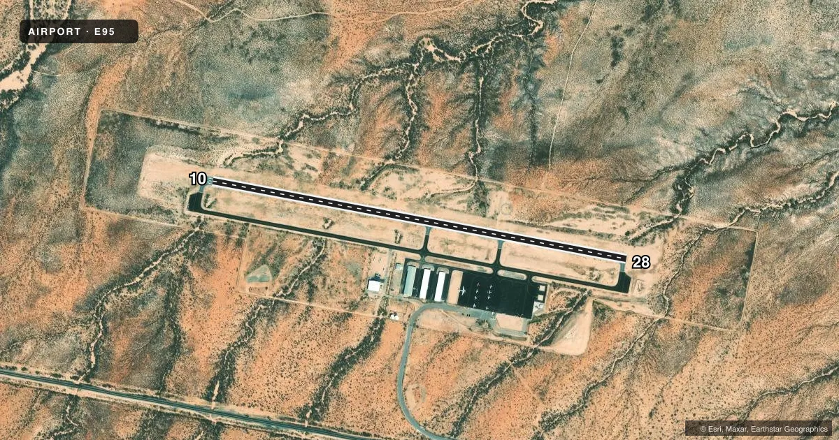
Airport sketch
Runways drawn to scale from FAA survey coordinates, rendered over satellite imagery. Not for navigation.
Approaches & charts
Services on the field
Fuel grades, oxygen, maintenance, ramp storage and lighting — as declared to the FAA by the airport operator.
Fuel & services
- Fuel
- 100LLA
- Airframe repair
- Minor
- Power plant repair
- Minor
- Other services
- INSTR,RNTL
Ramp & ground
- Transient storage
- Tie-down
- Hangar
- Lighting schedule
- SEE RMK
- Beacon schedule
- SS-SR
- Beacon
- White / Green (civil land)(WG)
- Wind indicator
- Lighted
- Segmented circle
- Yes
Fuel & FBOs
Cheapest 100LL and Jet A on the field and nearby. Always confirm with the FBO before taxi.
Airport notes
Surface conditions, obstructions, local procedures, lighting outages and other notes published with each FAA cycle.
General notes
- WILDLIFE ON & INVOF ARPT.
- FOR CD CTC TUCSON APCH AT 520-829-6121.
- FUEL H24 WITH CREDIT CARD.
Lighting notes
- ACTVT MIRL RWY 10/28 - CTAF.
Approach & departure obstructions
- 10ERRATIC WIND 0.5 NM FM THR WHEN +10 KTS. 110 FT TWY EXTDS FM THR TO THE W. FOUR 15 FT DITCHES BOTH SIDES OF RWY ENDS & W HALF OF RWY WITH HEADWALLS 130 FT S OF CNTRLN.
Other notes
- PROVIDED VFR OPNS ONLY.
- AVBLTY - AMGR.
VFR map & nearby airports
VFR sectional. Tap any ICAO chip to open that airport.
Key facts · E95
Answer card- ICAO
- E95
- Name
- BENSON MUNI/PAUL KERCHUM FLD
- Location
- BENSON, ARIZONA
- Elevation
- 3,830.9 ft MSL
- Traffic pattern altitude
- 4,830.9 ft MSL (1,000 AGL)
- Control tower
- Non-towered (use CTAF)
- Total runways
- 1
- Longest runway
- 10/28 · 4,002 ft
- Published ILS approaches
- 0
- Published frequencies
- 2
- Magnetic variation
- 12°
- Current flight rules
- VFR
- Current wind
- 210° at 3 kt
- Favored runway now
- RWY 28
Benson Muni / Paul Kerchum Fld sits in Benson, Arizona. The field elevation is 3,830.9 ft MSL. It has one runway. Runway 10/28 is 4,002 ft of asphalt, so plan performance with the elevation in mind. This is a non-towered field. CTAF and UNICOM are both 122.8. No ILS approaches are published here. Pattern altitude is not published, so use the standard 1,000 ft AGL for light piston traffic unless the current Chart Supplement says otherwise.
Southwestern Aviation is on the field. It carries 100LL. For clearance delivery, contact Tucson Approach at 520-829-6121. The published remarks also note wildlife on and near the airport. Runway 10/28 lighting is medium intensity and is activated by CTAF. The airport is for VFR operations only per the published remarks.
There are also a few local hazards to keep in mind. The remarks call out erratic wind about 0.5 NM from the threshold when wind is above 10 knots. They also note a 110-foot taxiway extending from the threshold to the west. Four 15-foot ditches are located on both sides of the runway ends and the west half of the runway. Headwalls are 130 feet south of the centerline. That makes a careful taxi and landing brief worth doing before you go.