METAR & TAF KOLS
Current METAR
Observed 15:54Z
KOLS 271554Z AUTO VRB03KT 10SM CLR 29/18 A3015 RMK AO2 SLP129 T02890183
- Wind
- VAR @ 3 kt
- Visibility
- 10 SM
- Temp / Dew
- 29°C / 18°C
- Altimeter
- 30.15 inHg
- Clouds
- CLR
- Density alt
- 6,299 ft
- Ceiling
- Unlimited
- Rules
- VFR
Airport info & contacts
Manager on record, flight service, ARTCC, attendance schedule and pattern altitude — published by the FAA and refreshed every 28 days.
Location
- From city
- 7 NM NE
- VFR sectional
- PHOENIX
- ARTCC
- ZAB · ALBUQUERQUE
- NOTAM facility
- OLS (NOTAM-D)
Airport manager
- Name
- SETH MILLER
- Phone
- 520-287-9120
- Address
- NOGALES INTL, 11 ACCESS WAY, NOGALES AZ 85621
Flight service · Hours
- FSS PRC
- PRESCOTT1-800-WX-BRIEF
- Attendance
- 0700-1900
Frequencies
Tap any row to copy the frequency to your clipboard.
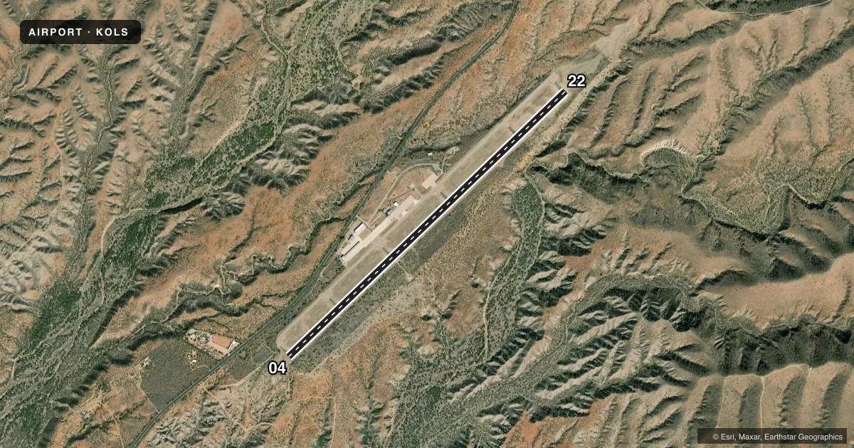
Runways & pattern
Full pagePattern entry · RWY 04
LEFT TRAFFICRunway end performance
| End | TORA | TODA | ASDA | LDA | VGSI | Approach lights | Obstruction |
|---|---|---|---|---|---|---|---|
| 04 | — | — | — | — | PAPI 4-box left(3°) | — | — |
| 22 | — | — | — | — | PAPI 4-box left(4°) | — | — |
Declared distances in feet. TORA = takeoff run available, TODA = takeoff distance, ASDA = accelerate-stop, LDA = landing distance.
Airport sketch
Runways drawn to scale from FAA survey coordinates, rendered over satellite imagery. Not for navigation.
Approaches & charts
Services on the field
Fuel grades, oxygen, maintenance, ramp storage and lighting — as declared to the FAA by the airport operator.
Fuel & services
- Fuel
- 100LLA
- Airframe repair
- Major
- Power plant repair
- Major
- Other services
- CHTR,INSTR,RNTL,SALES
Ramp & ground
- Transient storage
- Tie-down
- Hangar
- Landing fee
- No fee published
- Customs
- Available
- Lighting schedule
- SEE RMK
- Beacon schedule
- SS-SR
- Beacon
- White / Green (civil land)(WG)
- Wind indicator
- Lighted
- Segmented circle
- Yes
Fuel & FBOs
Cheapest 100LL and Jet A on the field and nearby. Always confirm with the FBO before taxi.
Airport notes
Surface conditions, obstructions, local procedures, lighting outages and other notes published with each FAA cycle.
General notes
- CLOSE FP - PRESCOTT RADIO 122.4.
- WILDLIFE ON OR INVOF ARPT.
- FOR CD CTC TUCSON APCH AT 520-829-6121.
Lighting notes
- ACTVT MIRL RWY 04/22 - CTAF.
Runway surface & condition
- 04/22CNTR 90 FT S-21; RMNG WIDTH S-7.
- 04/22RWY 22 CALM WIND RWY. SI NOT RCMDD.
Approach & departure obstructions
- 04TGL NA.
- 22PAPI UNUSBL BYD 5 DEGS LEFT OF CNTRLN. PAPI DOES NOT PRVD OBSTN CLNC BYD 5.0 NM FM THR.
- 22APCH SLOPE 20:1 TO DTHR.
VFR map & nearby airports
VFR sectional. Tap any ICAO chip to open that airport.
Key facts · KOLS
Answer card- ICAO
- KOLS
- Name
- NOGALES INTL
- Location
- NOGALES, ARIZONA
- Elevation
- 3,955.3 ft MSL
- Traffic pattern altitude
- 4,955.3 ft MSL (1,000 AGL)
- Control tower
- Non-towered (use CTAF)
- Total runways
- 1
- Longest runway
- 04/22 · 7,200 ft
- Published ILS approaches
- 0
- Published frequencies
- 4
- Magnetic variation
- 9°
- Current flight rules
- VFR
- Current wind
- 000° at 3 kt
- Favored runway now
- RWY 04
Nogales Intl is in Nogales, Arizona near the Mexico border. Field elevation is 3,955.3 ft MSL. The airport has one runway, 04/22, which is 7,200 ft long. There is no control tower. Approach and departure services are handled by Tucson Approach on 118.75 or 269.55 MHz.
No ILS approaches are published here. Pattern altitude is not published, so use the standard 1,000 ft AGL for light piston operations unless the current Chart Supplement says otherwise. Copper Mountain Air is on the field. It carries 100LL, Jet A and Jet A Prist. Call them at (520) 287-9120 for current service details.
A few remarks matter before you go. Wildlife is reported on or near the airport. Runway 22 is the calm wind runway. Straight-in approaches are not recommended. The PAPI on 22 is limited left of centerline. It does not give obstruction clearance beyond 5.0 NM from the threshold. Runway 04 has a note against touch-and-go landings. The runway lights are activated by CTAF. At this elevation, expect higher density altitude on warm days. Check performance carefully before departure.