METAR & TAF P04
P04 does not publish a METAR.
Showing the nearest reporting station: KDUG (BISBEE DOUGLAS INTL) · 15.5 NM away. Conditions at P04 may differ.
METAR · KDUG
Observed 11:56Z
KDUG 271156Z AUTO 35007KT 10SM CLR 23/17 A3009 RMK AO2 SLP108 T02280167 10283 20228 56001 TSNO
- Wind
- 350° @ 7 kt
- Visibility
- 10 SM
- Temp / Dew
- 23°C / 17°C
- Altimeter
- 30.09 inHg
- Clouds
- CLR
- Density alt
- 6,689 ft
- Ceiling
- Unlimited
- Rules
- VFR
Airport info & contacts
Manager on record, flight service, ARTCC, attendance schedule and pattern altitude — published by the FAA and refreshed every 28 days.
Location
- From city
- 5 NM SE
- VFR sectional
- PHOENIX
- ARTCC
- ZAB · ALBUQUERQUE
- NOTAM facility
- PRC (NOTAM-D)
Airport manager
- Name
- CITY OF BISBEE
- Phone
- 520-346-1099
- Address
- 118 ARIZONA ST, BISBEE AZ 85603
Flight service · Hours
- FSS PRC
- PRESCOTT1-800-WX-BRIEF
- Attendance
- ALL
Frequencies
Tap any row to copy the frequency to your clipboard.
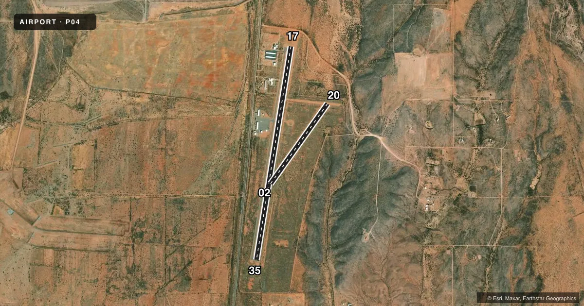
Runways & pattern
Full pagePattern entry · RWY 35
LEFT TRAFFIC| Runway | Heading (°M) | Length | Surface | Traffic |
|---|---|---|---|---|
| 17/35Favored | 177° / 357° | 5,929 ft | ASPH | Standard L |
| 02/20 | 23° / 203° | 2,700 ft | DIRT | Standard L |
Runway end performance
| End | TORA | TODA | ASDA | LDA | VGSI | Approach lights | Obstruction |
|---|---|---|---|---|---|---|---|
| 20 | — | — | — | — | — | — | 6', brush, 0' from thr, 60' R of cntrln, slope 0 |
Declared distances in feet. TORA = takeoff run available, TODA = takeoff distance, ASDA = accelerate-stop, LDA = landing distance.
Airport sketch
Runways drawn to scale from FAA survey coordinates, rendered over satellite imagery. Not for navigation.
Approaches & charts
Services on the field
Fuel grades, oxygen, maintenance, ramp storage and lighting — as declared to the FAA by the airport operator.
Fuel & services
- Fuel
- 100LL
- Other services
- INSTR
Ramp & ground
- Transient storage
- Tie-down
- Landing fee
- No fee published
- Customs
- Not available
- Lighting schedule
- SS-SR
- Beacon schedule
- SS-SR
- Beacon
- White / Green (civil land)(WG)
- Wind indicator
- Lighted
- Segmented circle
- Yes
Fuel & FBOs
Cheapest 100LL and Jet A on the field and nearby. Always confirm with the FBO before taxi.
Airport notes
Surface conditions, obstructions, local procedures, lighting outages and other notes published with each FAA cycle.
General notes
- GATES & LOUNGE CODE - CTAF.
- WILDLIFE ON OR INVOF ARPT.
- FOR CD IF UNA TO CTC ON FSS FREQ, CTC ALBUQUERQUE ARTCC AT 505-856-4561.
Fuel notes
- 100LLSELF SVC H24 WITH CREDIT CARD.
Runway surface & condition
- 17/35NSTD: EDGE LGT MOUNTED ALG BOTH SIDES RWY SFC.
Approach & departure obstructions
- 354-5 FT BRUSH 25-200 FT FM THR 65-125 FT R & 80-125 FT L OF CNTRLN.
- 02CTLG OBSTN EXCEEDS 45 DEG SLP.
VFR map & nearby airports
VFR sectional. Tap any ICAO chip to open that airport.
Key facts · P04
Answer card- ICAO
- P04
- Name
- BISBEE MUNI
- Location
- BISBEE, ARIZONA
- Elevation
- 4,790 ft MSL
- Traffic pattern altitude
- 5,790 ft MSL (1,000 AGL)
- Control tower
- Non-towered (use CTAF)
- Total runways
- 2
- Longest runway
- 17/35 · 5,929 ft
- Published ILS approaches
- 0
- Published frequencies
- 2
- Magnetic variation
- 12°
- Current flight rules
- VFR
- Current wind
- 350° at 7 kt
- Favored runway now
- RWY 35
Bisbee Muni sits in Bisbee, Arizona at 4,790 ft MSL. It has two runways. The longest is 17/35 at 5,929 ft. The shorter runway is 02/20 at 2,700 ft and it is dirt. There is no control tower. CTAF and UNICOM are both 122.8. No ILS approaches are published.
Pattern altitude is not published. Use 5,790 ft MSL for the standard 1,000 ft AGL pattern unless the current Chart Supplement says otherwise. The field is high enough that density altitude will matter on warm days. Plan performance with that in mind.
Bisbee Municipal Airport is on the field. It carries 100LL. Self-serve 100LL is available 24 hours with a credit card. Published remarks also note wildlife on or near the airport. Runway 17/35 has nonstandard edge lighting mounted along both sides of the runway surface. There are brush and obstruction notes near both ends of runway 17/35. That makes a careful look at the runway environment smart on first arrival.
If you need clearance delivery and cannot raise Flight Service, the remarks say to contact Albuquerque ARTCC. Gates and lounge code is the CTAF frequency. For anything current on procedures, noise, or field conditions, check the current FAA Chart Supplement or call the airport operator or FBO directly by phone before departure.