METAR & TAF KDUG
Current METAR
Observed 19:56Z
KDUG 271956Z AUTO 27010G19KT 10SM CLR 36/16 A3008 RMK AO2 SLP097 T03610156 TSNO
- Wind
- 270° @ 10G19 kt
- Visibility
- 10 SM
- Temp / Dew
- 36°C / 16°C
- Altimeter
- 30.08 inHg
- Clouds
- CLR
- Density alt
- 7,468 ft
- Ceiling
- Unlimited
- Rules
- VFR
Airport info & contacts
Manager on record, flight service, ARTCC, attendance schedule and pattern altitude — published by the FAA and refreshed every 28 days.
Location
- From city
- 8 NM NW
- VFR sectional
- PHOENIX
- ARTCC
- ZAB · ALBUQUERQUE
- NOTAM facility
- DUG (NOTAM-D)
Airport manager
- Name
- DARRELL CROWLEY
- Phone
- 520-432-9742
- Address
- 1415 W. MELODY LANE BLDG F, BISBEE AZ 85603
Flight service · Hours
- FSS PRC
- PRESCOTT1-800-WX-BRIEF
- Attendance
- MON-FRI · 0700-1500
Frequencies
Tap any row to copy the frequency to your clipboard.
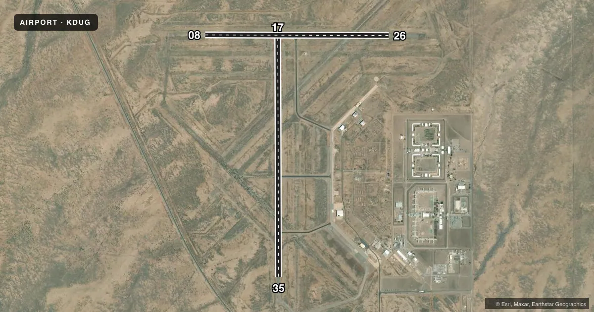
Runways & pattern
Full pagePattern entry · RWY 26
LEFT TRAFFIC| Runway | Heading (°M) | Length | Surface | Traffic |
|---|---|---|---|---|
| 17/35 | 168° / 348° | 6,430 ft | ASPH | Standard L |
| 08/26Favored | 78° / 258° | 4,966 ft | ASPH | Standard L |
Runway end performance
| End | TORA | TODA | ASDA | LDA | VGSI | Approach lights | Obstruction |
|---|---|---|---|---|---|---|---|
| 17 | — | — | — | — | VASI 2-box left(3.25°) | — | — |
| 08 | — | — | — | — | — | — | 8', brush, 264' from thr, 44' R of cntrln, slope 8 |
| 26 | — | — | — | — | — | — | 5', brush, 201' from thr, 70' R of cntrln, slope 0 |
Declared distances in feet. TORA = takeoff run available, TODA = takeoff distance, ASDA = accelerate-stop, LDA = landing distance.
Airport sketch
Runways drawn to scale from FAA survey coordinates, rendered over satellite imagery. Not for navigation.
Approaches & charts
Services on the field
Fuel grades, oxygen, maintenance, ramp storage and lighting — as declared to the FAA by the airport operator.
Fuel & services
- Fuel
- 100LLA1+
Ramp & ground
- Transient storage
- Tie-down
- Landing fee
- No fee published
- Customs
- Available
- Lighting schedule
- SEE RMK
- Beacon schedule
- SS-SR
- Beacon
- White / Green (civil land)(WG)
- Wind indicator
- Lighted
- Segmented circle
- Yes
Fuel & FBOs
Cheapest 100LL and Jet A on the field and nearby. Always confirm with the FBO before taxi.
Airport notes
Surface conditions, obstructions, local procedures, lighting outages and other notes published with each FAA cycle.
General notes
- WILDLIFE ON OR INVOF ARPT.
- FOR CD IF UNA TO CTC ON FSS FREQ, CTC ALBUQUERQUE ARTCC AT 505-856-4561.
Lighting notes
- ACTVT VASI RWY 17; MIRL RWY 17/35 - CTAF.
Fuel notes
- 100LLSELF SVC - AMGR.
Runway surface & condition
- 08/26DALGT VFR OPS ONLY.
Approach & departure obstructions
- 083- 10 FT BRUSH 0-200 FT FM THR 40-125 FT R OF CNTRLN.
- 1720 FT ACFT TAIL HEIGHT RWY 08/26 AT 55 FT TO CNTRLN; APCH SLOPE 04:1 AT THR.
- 264-6 FT BRUSH 20-200 FT FM THR 75 FT BOTH SIDES OF CNTRLN.
- 08CTLG OBSTN EXCEEDS 45 DEG SLOPE.
Other notes
- MANAGEREMERG - 520-559-8708.
- 17/35RFSC 100 FT WIDE.
VFR map & nearby airports
VFR sectional. Tap any ICAO chip to open that airport.
Key facts · KDUG
Answer card- ICAO
- KDUG
- Name
- BISBEE DOUGLAS INTL
- Location
- DOUGLAS BISBEE, ARIZONA
- Elevation
- 4,150.2 ft MSL
- Traffic pattern altitude
- 5,150.2 ft MSL (1,000 AGL)
- Control tower
- Non-towered (use CTAF)
- Total runways
- 2
- Longest runway
- 17/35 · 6,430 ft
- Published ILS approaches
- 0
- Published frequencies
- 2
- Magnetic variation
- 12°
- Current flight rules
- VFR
- Current wind
- 270° at 10 kt
- Favored runway now
- RWY 26
Bisbee Douglas Intl is in Douglas Bisbee, Arizona. Field elevation is 4,150.2 ft MSL. The airport has two asphalt runways. The longest is 17/35 at 6,430 ft. There is no control tower. CTAF and UNICOM are both 123.0. No ILS approaches are published here.
Pattern altitude is not published. Use the standard 1,000 ft AGL pattern for light piston traffic unless the current Chart Supplement says otherwise. The on-field FBO is Bisbee Douglas International Airport. It carries 100LL and Jet A Prist. Self-serve 100LL is available with the airport manager. Runway 17/35 has a rubberized friction surface coating and is 100 ft wide. Medium intensity runway lights are on runway 17/35. They are controlled by CTAF. A visual approach slope indicator is active for runway 17.
This is a high-elevation field, so performance planning matters. Published remarks also note wildlife on or near the airport. Runway 08/26 is daylight VFR only. There are published obstructions near multiple runway ends. Check the current Chart Supplement before you go. If you need clearance delivery and cannot raise Flight Service, contact Albuquerque ARTCC at 505-856-4561.