METAR & TAF KFHU
Current METAR
Observed 16:55Z
KFHU 271655Z AUTO 32007KT 10SM CLR 31/18 A3020 RMK AO2 SLP140 T03120178
- Wind
- 320° @ 7 kt
- Visibility
- 10 SM
- Temp / Dew
- 31°C / 18°C
- Altimeter
- 30.20 inHg
- Clouds
- CLR
- Density alt
- 7,424 ft
- Ceiling
- Unlimited
- Rules
- VFR
Airport info & contacts
Manager on record, flight service, ARTCC, attendance schedule and pattern altitude — published by the FAA and refreshed every 28 days.
Location
- From city
- 3 NM N
- VFR sectional
- PHOENIX
- ARTCC
- ZAB · ALBUQUERQUE
- NOTAM facility
- FHU (NOTAM-D)
Airport manager
- Name
- SHARON FLISSAR
- Phone
- 520-458-5775
- Address
- 401 GIULIO CESARE AVE, SIERRA VISTA AZ 85635
Flight service · Hours
- FSS PRC
- PRESCOTT1-800-WX-BRIEF
- Attendance
- MON-FRI · 1400-2230Z
Frequencies
Tap any row to copy the frequency to your clipboard.
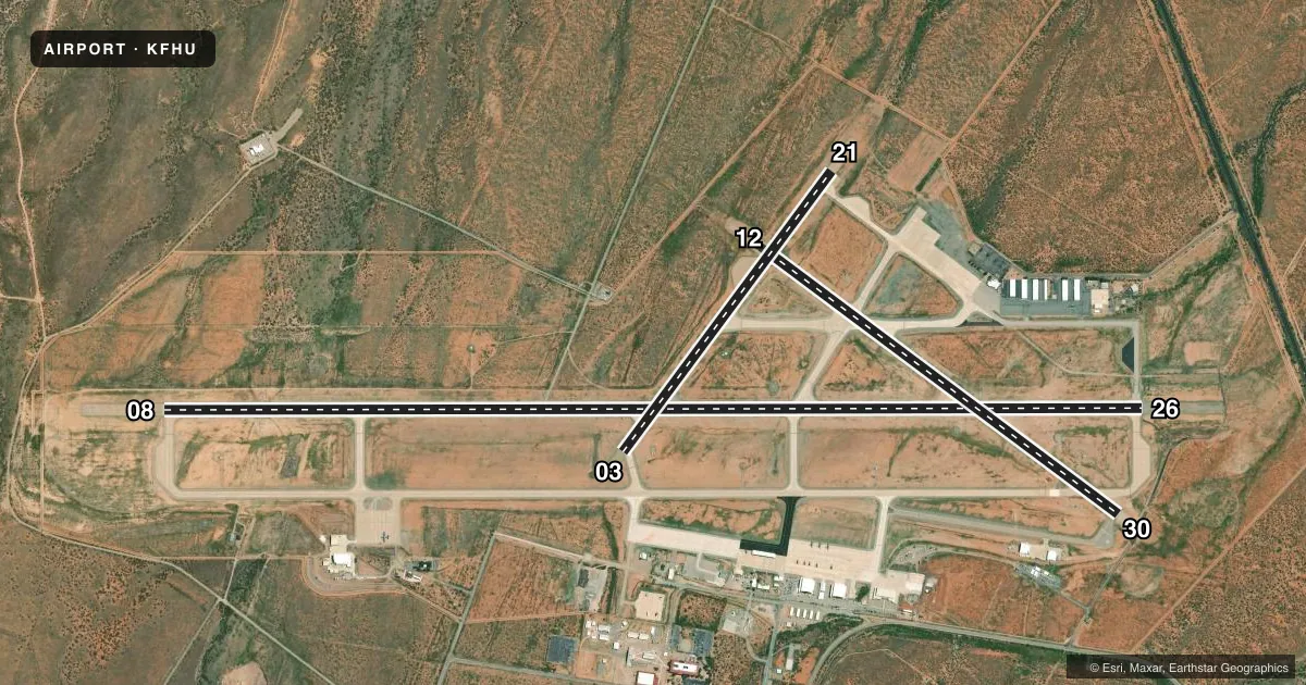
Runways & pattern
Full pagePattern entry · RWY 30
RIGHT TRAFFIC| Runway | Heading (°M) | Length | Surface | Traffic |
|---|---|---|---|---|
| 08/26 | 80° / 260° | 12,001 ft | CONC | 26 R |
| 12/30Favored | 117° / 297° | 5,367 ft | ASPH-CONC | 30 R |
| 03/21 | 27° / 207° | 4,286 ft | ASPH-CONC | 21 R |
Runway end performance
| End | TORA | TODA | ASDA | LDA | VGSI | Approach lights | Obstruction |
|---|---|---|---|---|---|---|---|
| 08 | 12,001' | 12,001' | 12,001' | 12,001' | PAPI 4-box left(3°) | — | — |
| 26 | 12,001' | 12,001' | 12,001' | 12,001' | PAPI 4-box left(3°) | — | — |
| 12 | 5,367' | 5,367' | 5,367' | 5,367' | PAPI 4-box left(3°) | — | — |
| 30 | 5,367' | 5,367' | 5,367' | 5,367' | PAPI 4-box right(3°) | — | — |
| 03 | 4,286' | 4,286' | 4,286' | 3,033' | — | — | — |
| 21 | 4,286' | 4,286' | 4,286' | 4,286' | — | — | — |
Declared distances in feet. TORA = takeoff run available, TODA = takeoff distance, ASDA = accelerate-stop, LDA = landing distance.
Airport sketch
Runways drawn to scale from FAA survey coordinates, rendered over satellite imagery. Not for navigation.
Approaches & charts
ILS · 1
Services on the field
Fuel grades, oxygen, maintenance, ramp storage and lighting — as declared to the FAA by the airport operator.
Fuel & services
- Fuel
- 100A
Ramp & ground
- Transient storage
- Tie-down
- Landing fee
- No fee published
- Customs
- Not available
- Lighting schedule
- SEE RMK
- Beacon schedule
- SS-SR
- Beacon
- White / Green (civil land)(WG)
- Wind indicator
- Lighted
- Segmented circle
- No
Fuel & FBOs
Cheapest 100LL and Jet A on the field and nearby. Always confirm with the FBO before taxi.
Airport notes
Surface conditions, obstructions, local procedures, lighting outages and other notes published with each FAA cycle.
General notes
- PRKG MIL TSNT SIGN IN AT BASE OPS PRIOR TO LV FLT LINE.
- TFC PAT: FIXED WING NORTH; ROTARY WING SOUTH; ALT FIXED WING RECIPROCATING 5700 FT; ROTOR WING 5500 FT; FIXED WING TURBOPROP/JET 6200 FT.
- WHEN CLASS D ASP IN EFCT UNMANNED AERIAL VEHICLES OPR SFC - 7000 FT MSL.
- USAF WX FCST AVBL 0500-2000 FM DAVIS MONTHAN AFB.
- TWY G & J LMTD TO SW ACFT MAX 33000 LB; TWY K LMTD TO SW ACFT MAX 50000 LB; TWY D & ACFT APRON ON NW SIDE LMTD TO DW ACFT MAX 100000 LB.
- CRCG S OF RWY 08 & 30 NA.
- MIL JET OPS WKDAYS; BIRD HAZ INVOF RWYS ON TKOF & APCH; DEER ON & INVOF ARPT SPCLY AT NIGHT.
- MIL POL 1530-2230Z MON-FRI; EXC HOL; OTR TIMES 24 HR PRIOR NOTICE - D879-2860/2862. POL SVC RQR CREW ATND TO SPECIFY FUEL/OIL RQMNTS; FUEL LMTD TO 6000 GAL; JET A AVBL 1400-2230Z DLY; OTR TIMES C520-234-3552; SVC FEE.
- TRAN ALERT: TSNT CTC BAOPS TO COORD PRKG.
- CSTMS/AG/IMG: AVBL WITH 72 HR PN FOR US MIL OR DOD CONTR ACFT ONLY.
- MISC: TSNT & RON ACFT USING MIL SIDE SIGN IN AT BAOPS PRIOR TO DEPG FLT LINE. ASSAULT STRIP 5 NM NE 72 HR PPR. NONSKED ARR RQRG ASST - EOC 533-2291.
- MILITARY USE: OPR 0600-0600Z SUN-SAT; EXC HOL. OTR TIME 72 HR PPR - D879-2860/2862/C520-538-2860/2862. SEE FLIP AP/1 SUPPLEMENTARY ARPT RMK.
- MISC: WX OBSN/FCST 0600-0600Z SUN-FRI; EXC HOL. OTR TIMES ASOS. LIBBY WX AVBL - 122.95 D879-3798/2865/C520-538-3798/2865.
- RSTD: 24 HR PPR FOR TSNT MIL.
- CTN: EXP WS ALL RWYS; ARPT SW WIND MAY NOT REP WIND ON FNA.
- MISC: REMOTE BRIEFING SVC AVBL 25 OWS DAVIS-MONTHAN AFB D228-6598/6599/6588/C520-228-6598/6599/6588 OR HTTPS://25OWS.US.AF.MIL.
- MISC: LIBBY BAOPS 0600-0600Z MON-SAT; EXC HOL. TR TIME 72 HR PPR. D879-2860/2862/C520-538-2860/2862.
- RSTD: TWY G LMTD TO S33; TWY K LMTD TO S50.
- ASP CLASS D SFC AREA LMTD TO DEP & FSL DURG NGT UNMANNED ACFT OPS; EXP DELAYS. MANNED & UNMANNED ACFT NOT AUTH IN SAME TFC PAT. MANNED ARR MAY FLW UNMANNED ACFT ON FNA.
- CIVIL TFC PAT UNAVBL DURG DALGT UNMANNED ACFT TFC PAT OPS; DEP & FSL AUTH.
- TPA: 981 FT AGL FIXED WING UNMANNED ACFT.
- TPA: DO NOT EXCEED 5700 FT UNTIL DER.
- CTN: RWY 08/26 & 12/30 OVRNS UNAVBL; BLW 25 PAVEMENT COND INDEX.
- TWY P & S EDGE LGT N/A.
Lighting notes
- ACTVT PAPI RWY 08, 26, 12 & 30; HIRL RWY 08/26; MIRL RWY 03/21 & 12/30; PERIMETER LGT H1 - CTAF.
Fuel notes
- AWO ICING INHIBITOR.
Other notes
- FORT HUACHUCA
- PER JOINT USE AGREEMENT.
- WHEN ATCT CLSD 121.5 MNTD FOR EMERG.
- MANAGERMIL CAROL THOMPSON - 520-538-2861
- OWNERAPRON, TRML & NE END OWNED BY CITY OF SIERRA VISTA.
VFR map & nearby airports
VFR sectional. Tap any ICAO chip to open that airport.
Key facts · KFHU
Answer card- ICAO
- KFHU
- Name
- SIERRA VISTA MUNI-LIBBY AAF
- Location
- FORT HUACHUCA SIERRA VISTA, ARIZONA
- Elevation
- 4,718.8 ft MSL
- Traffic pattern altitude
- 5,718.8 ft MSL (1,000 AGL)
- Control tower
- Towered · 0600Z MON-0600Z SAT; EXCP HOL, OTHER TIMES BY NOTAM.
- Total runways
- 3
- Longest runway
- 08/26 · 12,001 ft
- Published ILS approaches
- 1
- Published frequencies
- 13
- Magnetic variation
- 10°
- Current flight rules
- VFR
- Current wind
- 320° at 7 kt
- Favored runway now
- RWY 30
Sierra Vista Muni-Libby AAF sits at Fort Huachuca near Sierra Vista, Arizona. Field elevation is 4,718.8 ft MSL. The airport has three runways. The longest is 08/26 at 12,001 ft. The tower is open 0600Z Monday through 0600Z Saturday except holidays. Other times are by NOTAM. One ILS approach is published for runway 26.
Pattern altitude is not published for normal fixed-wing traffic in the facts provided. For fixed-wing unmanned operations, the published traffic pattern altitude is 981 ft AGL. The field is a joint-use military airport. Expect coordination needs that are not typical at a civilian strip. Published remarks say parking is military transient. Sign in at base operations before leaving the flight line. Transient aircraft should contact base operations to coordinate parking.
On-field fuel is available from Sierra Vista Municipal Airport. It carries 100LL, Jet A and Jet A Prist. The airport remarks also call out wind shear on all runways. The southwest wind at the field may not match what you see on final. That matters here because the airport sits at high elevation in southern Arizona. Check the current FAA Chart Supplement and coordinate with the airport operator or base operations before arrival if you need parking, access, or after-hours details.