METAR & TAF KTUS
Current METAR
Observed 15:53Z
KTUS 271553Z AUTO 00000KT 10SM CLR 33/18 A3005 RMK AO2 SLP118 T03280178
- Wind
- 000° @ 0 kt
- Visibility
- 10 SM
- Temp / Dew
- 33°C / 18°C
- Altimeter
- 30.05 inHg
- Clouds
- CLR
- Density alt
- 5,276 ft
- Ceiling
- Unlimited
- Rules
- VFR
Airport info & contacts
Manager on record, flight service, ARTCC, attendance schedule and pattern altitude — published by the FAA and refreshed every 28 days.
Location
- From city
- 6 NM S
- VFR sectional
- PHOENIX
- Pattern altitude
- 800 ft AGL · 3,443 ft MSL
- ARTCC
- ZAB · ALBUQUERQUE
- NOTAM facility
- TUS (NOTAM-D)
Airport manager
- Name
- DANETTE BEWLEY
- Phone
- 520-573-4820
- Address
- TUCSON APT AUTH 7250 S TUCSON BLVD, SUITE 300, TUCSON AZ 85756
Flight service · Hours
- FSS PRC
- PRESCOTT1-800-WX-BRIEF
- Attendance
- ALL
Frequencies
Tap any row to copy the frequency to your clipboard.
Runways & pattern
Full pagePattern entry · RWY 12
LEFT TRAFFIC| Runway | Heading (°M) | Length | Surface | Traffic |
|---|---|---|---|---|
| 12/30 | 126° / 306° | 10,996 ft | ASPH | 30 R |
| 04/22 | 36° / 216° | 7,000 ft | ASPH | 22 R |
Runway end performance
| End | TORA | TODA | ASDA | LDA | VGSI | Approach lights | Obstruction |
|---|---|---|---|---|---|---|---|
| 12 | 10,996' | 10,996' | 10,996' | 10,996' | PAPI 4-box left(3°) | MALSR | — |
| 30 | 10,996' | 10,996' | 10,996' | 10,996' | PAPI 4-box left(3°) | — | 8', gnd, 400' from thr, 500' R of cntrln, slope 25 |
| 04 | 7,000' | 7,000' | 7,000' | 6,150' | — | — | 21', rr, 270' from thr, 250' R of cntrln, slope 3 |
| 22 | 6,000' | 7,000' | 6,000' | 6,000' | PAPI 4-box left(3°) | — | — |
Declared distances in feet. TORA = takeoff run available, TODA = takeoff distance, ASDA = accelerate-stop, LDA = landing distance.
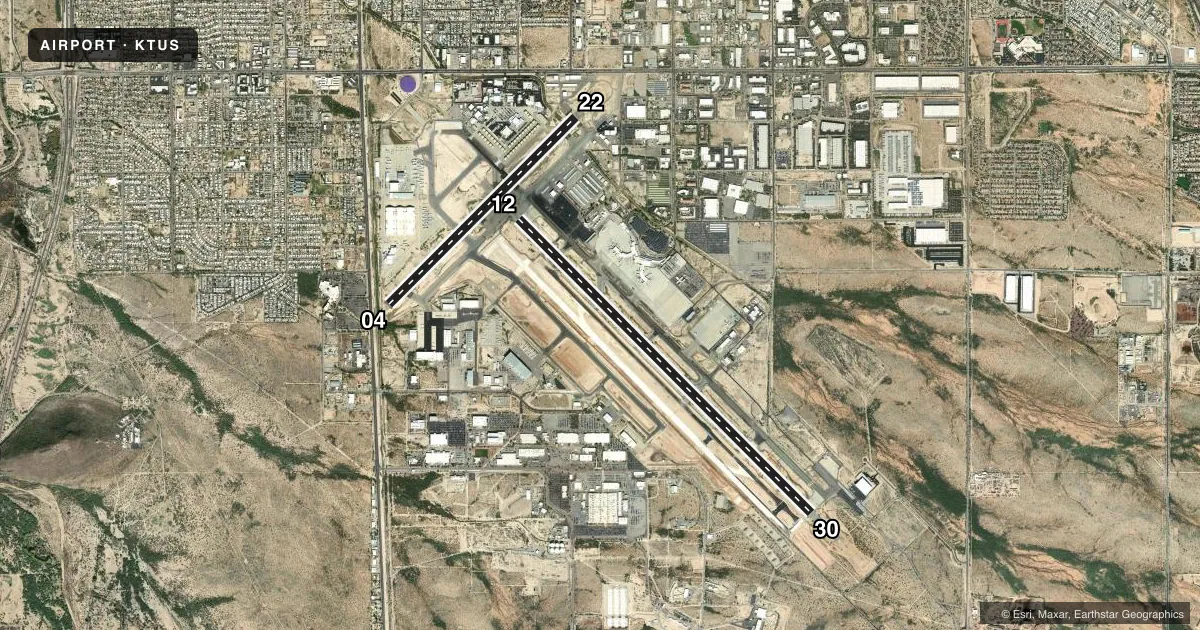
Airport sketch
Runways drawn to scale from FAA survey coordinates, rendered over satellite imagery. Not for navigation.
Approaches & charts
ILS · 1
Services on the field
Fuel grades, oxygen, maintenance, ramp storage and lighting — as declared to the FAA by the airport operator.
Fuel & services
- Fuel
- 100LLAA++
- Oxygen (bottled)
- HIGH/LOW
- Oxygen (bulk)
- HIGH/LOW
- Airframe repair
- Major
- Power plant repair
- Major
- Other services
- AFRT,AMB,AVNCS,CARGO,CHTR,INSTR,RNTL,SALES,SURV
Ramp & ground
- Transient storage
- Tie-down
- Landing fee
- No fee published
- Customs
- Available
- Lighting schedule
- SS-SR
- Beacon schedule
- SS-SR
- Beacon
- White / Green (civil land)(WG)
- Wind indicator
- Lighted
- Segmented circle
- No
Fuel & FBOs
Cheapest 100LL and Jet A on the field and nearby. Always confirm with the FBO before taxi.
Airport notes
Surface conditions, obstructions, local procedures, lighting outages and other notes published with each FAA cycle.
General notes
- CTN: NW ARR & DEP DO NOT MISTAKE TWY A FOR LNDG SFC; TWY A N & PARL TO RWY 30.
- PTNS TWY D NOT VIS FM ATCT.
- FLT TRNG 2200-0600 NA EXC PPR - 520-573-8190.
- GROUP V TAX WITH INBOARD ENG ONLY. TRML RAMP CLSD TO ADG IV & ABV WO PPR.
- A GEAR - BAK-14 BAK-12B APCH END RWY 12, BAK-14 BAK-12B APCH END RWY 30 & BAK-14 BAK-12B APCH END RWY 22 AVBL DURG ANG DUTY HR: 5 MIN PN.
- TWY A5 LTD 70000 LB OR LESS.
- MIL: ANG OFFL BUS ONLY; 72 HR PPR - D844-6731/C520-295-6731; FAX EXTN 6732. BASE OPS 1300Z-2230Z MON-FRI & DRILL WKEND 1300Z-2130Z; CLSD OTR WKENDS, HOL & SKED OFF DAYS. TRAN ALERT MAINT NA. TSNT SI FSL ONLY. CONTR FUEL NA.
- USE UPPER ANT UNTIL AIRBORNE.
- CHARTER, SPORT TEAM, CARGO & MIL PPR - FBO. LNDG & PRKG FEE 12500 LBS & UP.
- MIL/COMM/BASE OPS ARR CTC TITAN OR PUMA - ANG BASE OPS/COMD POST FREQ.
- MIL: BIRD ACT PHASE II IN EFCT 1 JUL-31 AUG.
- USCBP INSP RAMP RFLG NA EXC MED EMERG.
- GEN INFO - 520-573-8182.
- CTN: REVIEW ARPT DIAGRAM HOT SPOT INFO.
- OPR PARROT ALL SFCS, PUSHBACK & GATE ARR.
- N RAMP CLSD TO WINGSPAN GTR THAN 79 FT.
- TXL K CLSD TO WINGSPAN GTR THAN 104 FT.
- TWY C CLSD TO WINGSPAN GTR THAN 118 FT & TAIL HGT GTR THAN 45 FT.
Runway surface & condition
- 04/22PCR VALUE: 470/F/A/X/T
- 12/30PCR VALUE: 650/R/A/W/T
- 12/30FIXED WING JET VSTOL/VTOL OPS NA. DSTC RMNG MKRS NE SIDE.
- 12/30EXCEEDS 200 FT SPACING AT TWY INTXN ON N & S SIDE OF RWY.
Approach & departure obstructions
- 30CTN: ENSURE DEP RWY; DO NOT MISTAKE FOR DEMOL RWY.
Arresting gear
- 04_BAK-12BBAK-14 BAK-12B(B) (1500).
- 12_BAK-14BAK-14 BAK-12B(B) (1000).
- 30_BAK-12BBAK-14 BAK-12(B) (1215) HOOK BAK 12B(B) (128 OVRN).
Other notes
- TPA 800 FT AGL SMALL ACFT; 1400 FT AGL LARGE/HEAVY TURBOJET ACFT.
- MANAGERADAM MERRILL 520-573-5112.
VFR map & nearby airports
VFR sectional. Tap any ICAO chip to open that airport.
Key facts · KTUS
Answer card- ICAO
- KTUS
- Name
- TUCSON INTL
- Location
- TUCSON, ARIZONA
- Elevation
- 2,643 ft MSL
- Traffic pattern altitude
- 3,443 ft MSL (800 AGL)
- Control tower
- Towered · 24
- Total runways
- 2
- Longest runway
- 12/30 · 10,996 ft
- Published ILS approaches
- 1
- Published frequencies
- 30
- Magnetic variation
- 9°
- Current flight rules
- VFR
- Current wind
- 000° at 0 kt
- Favored runway now
- –
Tucson Intl is in Tucson, Arizona. The field elevation is 2,643 ft MSL. It has two asphalt runways. The longest is runway 12/30 at 10,996 ft. The tower is open 24 hours. One ILS is published for runway 12. Pattern altitude is 800 ft AGL, which is 3,443 ft MSL.
On the field, Atlantic Aviation carries 100LL and Jet A. Tucson Jet Center carries 100LL, Jet A and Jet A Prist. Million Air carries 100LL, Jet A and Jet A Prist. Executive Air carries 100LL, Jet A and Jet A Prist. For a first-time arrival, this is a busy Class C airport in a large metro area. Expect controlled traffic flow and plan to get the current ATIS before calling approach or tower. The published remarks also matter here. Flight training is not authorized from 2200 to 0600 without prior permission. The north ramp is closed to wingspans greater than 79 feet. Some military and ramp access items are restricted. Check the current Chart Supplement and coordinate with the airport operator or the FBO directly by phone if your operation is anything out of the ordinary.