METAR & TAF KAVQ
Current METAR
Observed 16:15Z
KAVQ 271615Z AUTO 00000KT 10SM CLR 35/17 A2999 RMK AO2
- Wind
- 000° @ 0 kt
- Visibility
- 10 SM
- Temp / Dew
- 35°C / 17°C
- Altimeter
- 29.99 inHg
- Clouds
- CLR
- Density alt
- 4,832 ft
- Ceiling
- Unlimited
- Rules
- VFR
Airport info & contacts
Manager on record, flight service, ARTCC, attendance schedule and pattern altitude — published by the FAA and refreshed every 28 days.
Location
- From city
- 15 NM NW
- VFR sectional
- PHOENIX
- ARTCC
- ZAB · ALBUQUERQUE
- NOTAM facility
- PRC (NOTAM-D)
Airport manager
- Name
- GALEN BEEM
- Phone
- 520-382-8053
- Address
- 11700 W. AVRA VALLEY RD, #91, TOWN OF MARANA, MARANA AZ 85653
Flight service · Hours
- FSS PRC
- PRESCOTT1-800-WX-BRIEF
- Attendance
- 0700-1730
Frequencies
Tap any row to copy the frequency to your clipboard.
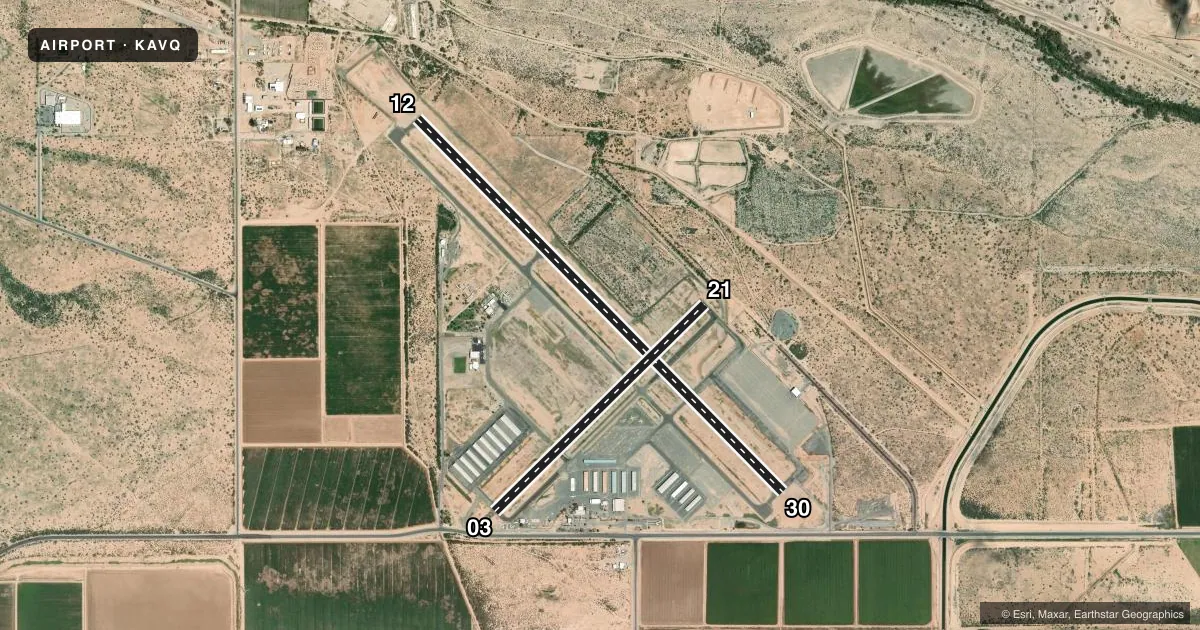
Runways & pattern
Full pagePattern entry · RWY 12
LEFT TRAFFIC| Runway | Heading (°M) | Length | Surface | Traffic |
|---|---|---|---|---|
| 12/30 | 123° / 303° | 6,901 ft | ASPH | 30 R |
| 03/21 | 33° / 213° | 3,892 ft | ASPH | 03 R |
Runway end performance
| End | TORA | TODA | ASDA | LDA | VGSI | Approach lights | Obstruction |
|---|---|---|---|---|---|---|---|
| 12 | — | — | — | — | PAPI 4-box left(3.06°) | — | — |
| 30 | — | — | — | — | PAPI 4-box left(3.41°) | — | — |
| 03 | — | — | — | — | PAPI 2-box left(2.91°) | — | 15', road, 200' from thr, 250' R of cntrln, slope 0 |
| 21 | — | — | — | — | PAPI 2-box left(2.91°) | — | 13', brush, 225' from thr, 150' R of cntrln, slope 1 |
Declared distances in feet. TORA = takeoff run available, TODA = takeoff distance, ASDA = accelerate-stop, LDA = landing distance.
Airport sketch
Runways drawn to scale from FAA survey coordinates, rendered over satellite imagery. Not for navigation.
Approaches & charts
Services on the field
Fuel grades, oxygen, maintenance, ramp storage and lighting — as declared to the FAA by the airport operator.
Fuel & services
- Fuel
- 100LLA++
- Oxygen (bottled)
- High pressure
- Airframe repair
- Major
- Power plant repair
- Minor
- Other services
- INSTR,PAJA,RNTL
Ramp & ground
- Transient storage
- Tie-down
- Hangar
- Landing fee
- No fee published
- Customs
- Not available
- Lighting schedule
- SEE RMK
- Beacon schedule
- SS-SR
- Beacon
- White / Green (civil land)(WG)
- Wind indicator
- Lighted
- Segmented circle
- Yes
Fuel & FBOs
Cheapest 100LL and Jet A on the field and nearby. Always confirm with the FBO before taxi.
Airport notes
Surface conditions, obstructions, local procedures, lighting outages and other notes published with each FAA cycle.
General notes
- AEROBATIC ACT 2 MI SE SFC-7000 FT MSL; HIGH & LOW LEVEL PRCHT TRNG NW QUAD.
- HEL LND SE HELIPAD ONLY; FUEL & TERM RAMP LNDG NA.
- FOR CD CTC TUCSON APCH AT 520-829-6121.
- PREF TFC PAT ALT 3000 FT MSL, LIGHT ACFT; 3500 FT MSL, HEAVY ACFT.
- FRMN FLT PPR WI 5 NM - AMGR.
- SELF SVC CREDIT CARD FUEL H24. AFT HR CALL OUT FEE - 520-730-4318.
- HOT AIR BALLON OPS NA.
Lighting notes
- ACTVT REIL RWY 12 & 30; MIRL RWY 03/21 & 12/30 - CTAF. PAPI RWY 03, 12, 21 & 30 ON CONSLY.
Runway surface & condition
- 12/30RWY 12 CALM WIND RWY.
Approach & departure obstructions
- 21PAPI UNUSBL BYD 7.0 NM DUE TO TRRN.
- 30PAPI UNUSBL BYD 3.5 NM DUE TO TRRN.
- 03APCH RATIO 50:1 TO DTHR.
Other notes
- FOR AVBLTY - 520-682-2999.
- MANAGER520-382-2607
VFR map & nearby airports
VFR sectional. Tap any ICAO chip to open that airport.
Key facts · KAVQ
Answer card- ICAO
- KAVQ
- Name
- MARANA RGNL
- Location
- MARANA, ARIZONA
- Elevation
- 2,031.5 ft MSL
- Traffic pattern altitude
- 3,031.5 ft MSL (1,000 AGL)
- Control tower
- Non-towered (use CTAF)
- Total runways
- 2
- Longest runway
- 12/30 · 6,901 ft
- Published ILS approaches
- 0
- Published frequencies
- 4
- Magnetic variation
- 12°
- Current flight rules
- VFR
- Current wind
- 000° at 0 kt
- Favored runway now
- –
Marana Rgnl sits in Marana, Arizona, northwest of Tucson. Field elevation is 2,031.5 ft MSL. The airport has 2 asphalt runways. The longest is 6,901 ft on runway 12/30. There is no control tower. No ILS approaches are published here. Pattern altitude is not published. The Chart Supplement lists a preferred traffic pattern altitude of 3,000 ft MSL for light aircraft. Heavy aircraft use 3,500 ft MSL.
Tucson Aeroservice Center is the on-field FBO. It carries 100LL, Jet A and Jet A Prist. Self-serve credit card fuel is available 24 hours a day. If you need after-hours fuel, call the number in the Chart Supplement before you go. The field also has a few operational points worth planning around. Runway 12 is the calm wind runway. PAPI on runway 21 is unusable beyond 7 NM because of terrain. PAPI on runway 30 is unusable beyond 3.5 NM because of terrain. Runway 03 has a 50:1 slope to the displaced threshold. The airport also has published activity nearby from aerobatics, parachute training and balloon operations are not authorized.
For a first-time arrival, treat this as a high-desert airport with a busy mix of local activity. File a flight plan and get prior permission within 5 NM of the airport manager. Check the current FAA Chart Supplement for any noise or curfew restrictions before flying into the field.