METAR & TAF A39
Current METAR
Observed 08:35Z
KA39 270835Z AUTO 28010KT 10SM CLR 34/20 A2989 RMK AO2
- Wind
- 280° @ 10 kt
- Visibility
- 10 SM
- Temp / Dew
- 34°C / 20°C
- Altimeter
- 29.89 inHg
- Clouds
- CLR
- Density alt
- 3,938 ft
- Ceiling
- Unlimited
- Rules
- VFR
Airport info & contacts
Manager on record, flight service, ARTCC, attendance schedule and pattern altitude — published by the FAA and refreshed every 28 days.
Location
- From city
- 5 NM ESE
- VFR sectional
- PHOENIX
- ARTCC
- ZAB · ALBUQUERQUE
- NOTAM facility
- PRC (NOTAM-D)
Airport manager
- Name
- RENE SASPE
- Phone
- 520-568-1684
- Address
- 32514 W. BUD RD, MARICOPA AZ 85138
Flight service · Hours
- FSS PRC
- PRESCOTT1-800-WX-BRIEF
- Attendance
- MON-FRI · 0730-1500
Frequencies
Tap any row to copy the frequency to your clipboard.
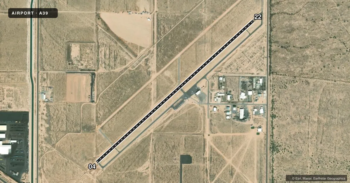
Runways & pattern
Full pagePattern entry · RWY 22
LEFT TRAFFICRunway end performance
| End | TORA | TODA | ASDA | LDA | VGSI | Approach lights | Obstruction |
|---|---|---|---|---|---|---|---|
| 04 | 4,751' | 4,751' | 4,751' | 4,751' | — | — | — |
| 22 | 4,751' | 4,751' | 4,751' | 4,461' | — | — | 8', fence, 240' from thr, 128' R of cntrln, slope 5 |
Declared distances in feet. TORA = takeoff run available, TODA = takeoff distance, ASDA = accelerate-stop, LDA = landing distance.
Airport sketch
Runways drawn to scale from FAA survey coordinates, rendered over satellite imagery. Not for navigation.
Approaches & charts
Services on the field
Fuel grades, oxygen, maintenance, ramp storage and lighting — as declared to the FAA by the airport operator.
Fuel & services
- Fuel
- 100LL
- Other services
- INSTR,RNTL
Ramp & ground
- Transient storage
- Tie-down
- Lighting schedule
- SEE RMK
- Beacon schedule
- SS-SR
- Beacon
- White / Green (civil land)(WG)
- Wind indicator
- Yes
- Segmented circle
- Yes
Fuel & FBOs
Cheapest 100LL and Jet A on the field and nearby. Always confirm with the FBO before taxi.
Airport notes
Surface conditions, obstructions, local procedures, lighting outages and other notes published with each FAA cycle.
General notes
- +300 FT ANT 3 MI WNW FM AK-CHIN RGNL ARPT W BDRY.
- 45 FT PWR LINE 2 MI SSW & 2 MI NE.
- ULTRALIGHT ACT INVOF ARPT.
- FOR CD CTC ALBUQUERQUE ARTCC AT 505-856-4861.
Lighting notes
- ACTVT MIRL RWY 4/22 - CTAF.
Fuel notes
- 100LLH24 CREDIT CARD SVC AVBL; AMERICAN EXPRESS NA.
Approach & departure obstructions
- 22+8 FT FENCE 116 FT FM RWY END. HWY 166 FT FM RWY END.
- 2237:1 CLNC SLP TO DTHR; 15 FT ROAD 565 FT FM DTHR 175 FT L OF CNTRLN.
Other notes
- SEE AIRSPACE CASE 98-AWP-35-NRA
- MANAGER520-840-4066.
VFR map & nearby airports
VFR sectional. Tap any ICAO chip to open that airport.
Key facts · A39
Answer card- ICAO
- A39
- Name
- AK-CHIN RGNL
- Location
- MARICOPA, ARIZONA
- Elevation
- 1,307 ft MSL
- Traffic pattern altitude
- 2,307 ft MSL (1,000 AGL)
- Control tower
- Non-towered (use CTAF)
- Total runways
- 1
- Longest runway
- 04/22 · 4,751 ft
- Published ILS approaches
- 0
- Published frequencies
- 1
- Magnetic variation
- 12°
- Current flight rules
- VFR
- Current wind
- 280° at 10 kt
- Favored runway now
- RWY 22
AK-CHIN RGNL sits in Maricopa, Arizona. Field elevation is 1,307 ft MSL. The airport has one runway, 04/22, which is 4,751 ft long. There is no control tower. CTAF is 122.9. No ILS approaches are published here.
Pattern altitude is not published. Use 1,000 ft AGL for light piston operations unless the current Chart Supplement says otherwise. The on-field FBO is Ak-Chin Indian Community. It carries AVGAS 100LL. Twenty-four-hour credit card fuel service is published. American Express is not accepted.
This is a non-towered field, so self-announce early and keep a sharp scan for local traffic. Ultralight activity is published in the area. Medium intensity runway lights on 04/22 are activated by CTAF. There is also a 300-foot antenna 3 miles west-northwest of the west boundary. A 45-foot power line is published 2 miles south-southwest and 2 miles northeast. For clearance delivery, contact Albuquerque ARTCC. Check the current Chart Supplement for any published noise or curfew restrictions before flying into the field. The airport manager can be reached by phone if you need current field information.