METAR & TAF E68
E68 does not publish a METAR.
Showing the nearest reporting station: KCHD (CHANDLER MUNI) · 20.8 NM away. Conditions at E68 may differ.
METAR · KCHD
Observed 02:47Z
KCHD 270247Z 27005KT 10SM FEW150 41/16 A2982
- Wind
- 270° @ 5 kt
- Visibility
- 10 SM
- Temp / Dew
- 41°C / 16°C
- Altimeter
- 29.82 inHg
- Clouds
- FEW
- Density alt
- 4,823 ft
- Ceiling
- Unlimited
- Rules
- VFR
Airport info & contacts
Manager on record, flight service, ARTCC, attendance schedule and pattern altitude — published by the FAA and refreshed every 28 days.
Location
- From city
- 6 NM W
- VFR sectional
- PHOENIX
- ARTCC
- ZAB · ALBUQUERQUE
- NOTAM facility
- PRC (NOTAM-D)
Airport manager
- Name
- JASON STEPHENS
- Phone
- 520-568-2318
- Address
- PO BOX 858, MARICOPA AZ 85239
Flight service · Hours
- FSS PRC
- PRESCOTT1-800-WX-BRIEF
- Attendance
- 0900-1700
Frequencies
Tap any row to copy the frequency to your clipboard.
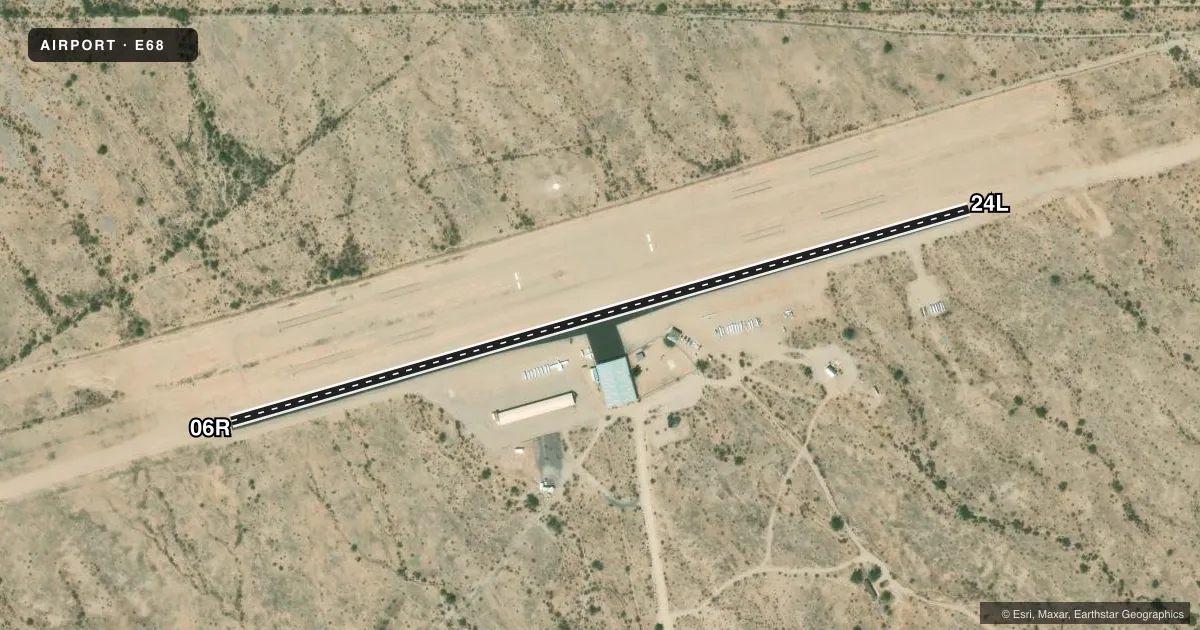
Runways & pattern
Full pagePattern entry · RWY 24L
LEFT TRAFFICAirport sketch
Runways drawn to scale from FAA survey coordinates, rendered over satellite imagery. Not for navigation.
Approaches & charts
Services on the field
Fuel grades, oxygen, maintenance, ramp storage and lighting — as declared to the FAA by the airport operator.
Fuel & services
- Fuel
- Not available
- Other services
- INSTR,RNTL,TOW
Ramp & ground
- Transient storage
- Tie-down
- Landing fee
- No fee published
- Customs
- Not available
- Wind indicator
- Yes
- Segmented circle
- Yes
Fuel & FBOs
Cheapest 100LL and Jet A on the field and nearby. Always confirm with the FBO before taxi.
Airport notes
Surface conditions, obstructions, local procedures, lighting outages and other notes published with each FAA cycle.
General notes
- OBSTRNS MTNS SW, N & NW. 1 FT BERM & 1 FT DITCH 30 FT NORTH OF RWY 06L/24R.
- PWR ACFT PAT S OF RWYS; GLIDER PAT N OF RWYS.
- PWR OPS USE RWY NOT IN USE BY GLIDERS.
- AEROBATIC BOX ACTV 0900-1800; ONE SQUARE MI ARND PXR194023.
- HVY NO RADIO ACT.
- TKOFF PAVED RWY ONLY.
- ALERT: HVY GLIDER TFC OPS WO COM WI 5 NM.
- ALL OPS PPR DUE TO GLIDER ACT - AMGR.
- ARPT CLSD AT NIGHT.
- FOR CD CTC PHOENIX APCH AT 602-306-2565.
- GLIDERS NOT EQUIPPED WITH ADS-B
Approach & departure obstructions
- 06R4 FT BRUSH 117 FT L AT RWY END.
- 24L5 FT BRUSH 40 FT L & 0-20 FT RWY END.
- 07CLSD INDEFLY.
Other notes
- 123.3 AVBL FOR COMM BTN GLIDER & TOW ACFT.
- INSTRGLIDER SVC ONLY.
VFR map & nearby airports
VFR sectional. Tap any ICAO chip to open that airport.
Key facts · E68
Answer card- ICAO
- E68
- Name
- ESTRELLA SAILPORT
- Location
- MARICOPA, ARIZONA
- Elevation
- 1,273 ft MSL
- Traffic pattern altitude
- 2,273 ft MSL (1,000 AGL)
- Control tower
- Non-towered (use CTAF)
- Total runways
- 1
- Longest runway
- 06R/24L · 2,520 ft
- Published ILS approaches
- 0
- Published frequencies
- 0
- Magnetic variation
- 13°
- Current flight rules
- VFR
- Current wind
- 270° at 5 kt
- Favored runway now
- RWY 24L
Estrella Sailport (E68) sits in Maricopa, Arizona at 1,273 ft MSL. The field has one paved runway, 06R/24L, which is 2,520 ft long. There is no control tower. No ILS approaches are published. Pattern altitude is not published, so use standard traffic pattern planning unless the current Chart Supplement says otherwise.
This is a glider-focused field. All operations require prior permission because of glider activity. The published remarks also say glider service only. Powered aircraft use runways not in use by gliders. Takeoff is permitted from paved runways only. There is no on-field FBO listed, so contact the airport manager before you go. For clearance delivery, Phoenix Approach is listed at 602-306-2565.
There are a few operational items to watch. Runway 07 is closed indefinitely. There is brush near the ends of 06R and 24L. Mountains are noted southwest, north and northwest of the field. An aerobatic box is active from 0900 to 1800 around PXR194023. Gliders are not equipped with ADS-B. If you are planning a first visit, verify current procedures with the airport manager. Expect to coordinate closely with glider traffic.