METAR & TAF E63
E63 does not publish a METAR.
Showing the nearest reporting station: KBXK (BUCKEYE MUNI) · 27.8 NM away. Conditions at E63 may differ.
METAR · KBXK
Observed 13:35Z
KBXK 271335Z AUTO 24004KT 6SM HZ CLR 32/18 A2989 RMK AO2
- Wind
- 240° @ 4 kt
- Visibility
- 6 SM
- Temp / Dew
- 32°C / 18°C
- Altimeter
- 29.89 inHg
- Clouds
- CLR
- Density alt
- 3,055 ft
- Ceiling
- Unlimited
- Rules
- VFR
Airport info & contacts
Manager on record, flight service, ARTCC, attendance schedule and pattern altitude — published by the FAA and refreshed every 28 days.
Location
- From city
- 2 NM E
- VFR sectional
- PHOENIX
- Pattern altitude
- 800 ft AGL · 1,589 ft MSL
- ARTCC
- ZAB · ALBUQUERQUE
- NOTAM facility
- PRC (NOTAM-D)
Airport manager
- Name
- COREY DRURY
- Phone
- 623-810-4662
- Address
- TOWN OF GILA BEND, DEPT. OF PUB WKS P.O. BOX A, GILA BEND AZ 85337
Flight service · Hours
- FSS PRC
- PRESCOTT1-800-WX-BRIEF
- Attendance
- Unattended
Frequencies
Tap any row to copy the frequency to your clipboard.
Runways & pattern
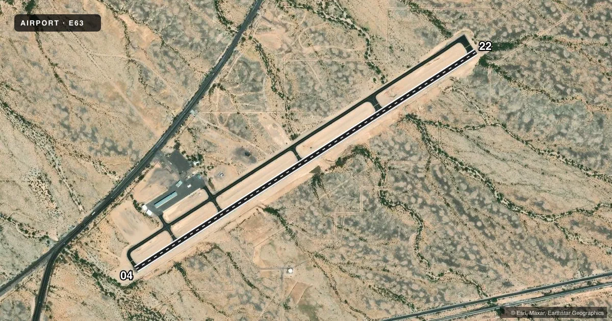
Full pagePattern entry · RWY 22
LEFT TRAFFICRunway end performance
| End | TORA | TODA | ASDA | LDA | VGSI | Approach lights | Obstruction |
|---|---|---|---|---|---|---|---|
| 04 | — | — | — | — | PAPI 2-box left(3°) | — | 20', tree, 266' from thr, 30' R of cntrln, slope 3 |
| 22 | — | — | — | — | PAPI 2-box left(3°) | — | 16', tree, 202' from thr, 50' R of cntrln, slope 0 |
Declared distances in feet. TORA = takeoff run available, TODA = takeoff distance, ASDA = accelerate-stop, LDA = landing distance.
Airport sketch
Runways drawn to scale from FAA survey coordinates, rendered over satellite imagery. Not for navigation.
Approaches & charts
Services on the field
Fuel grades, oxygen, maintenance, ramp storage and lighting — as declared to the FAA by the airport operator.
Fuel & services
- Fuel
- 100LL
Ramp & ground
- Transient storage
- Tie-down
- Landing fee
- No fee published
- Customs
- Not available
- Lighting schedule
- SEE RMK
- Beacon schedule
- SS-SR
- Beacon
- White / Green (civil land)(WG)
- Wind indicator
- Lighted
- Segmented circle
- Yes
Fuel & FBOs
Cheapest 100LL and Jet A on the field and nearby. Always confirm with the FBO before taxi.
Airport notes
Surface conditions, obstructions, local procedures, lighting outages and other notes published with each FAA cycle.
General notes
- FOR CD CTC LUKE APCH AT 623-856-7361. IF UNA CTC ALBUQUERQUE ARTCC AT 505-856-4861.
- AREA ALG RWY NRWS TO 30 FT AT CULVERT.
- TWY LGT OTS INDEFLY.
Lighting notes
- ACTVT MIRL RWY 04/22 - CTAF.
Fuel notes
- 100LLSELF SVC H24 WITH CREDIT CARD.
Runway surface & condition
- 04/22PRIMARY SFC +5-20 FT BRUSH & TREES 100-125 FT S OF CNTRLN.
- 04/22OTS INDEFLY.
Approach & departure obstructions
- 223-15 FT BRUSH 0-200 FT FM THR 65-125 FT L OF CNTRLN.
- 04CTLG OBSTN EXCEEDS 45 DEG SLOPE.
Other notes
- OTS INDEFLY.
VFR map & nearby airports
VFR sectional. Tap any ICAO chip to open that airport.
Key facts · E63
Answer card- ICAO
- E63
- Name
- GILA BEND MUNI
- Location
- GILA BEND, ARIZONA
- Elevation
- 788.7 ft MSL
- Traffic pattern altitude
- 1,588.7 ft MSL (800 AGL)
- Control tower
- Non-towered (use CTAF)
- Total runways
- 1
- Longest runway
- 04/22 · 5,200 ft
- Published ILS approaches
- 0
- Published frequencies
- 2
- Magnetic variation
- 13°
- Current flight rules
- VFR
- Current wind
- 240° at 4 kt
- Favored runway now
- RWY 22
Gila Bend Muni sits in Gila Bend, Arizona. The field elevation is 788.7 ft MSL. It has one runway. Runway 04/22 is 5,200 ft long, so that is the longest runway here too. The airport is non-towered. CTAF and UNICOM are both 122.8. Pattern altitude is 800 ft AGL, which is 1,588.7 ft MSL.
There are no ILS approaches published. Imperial Flying Service is on the field. It carries AVGAS 100LL. Self-serve 100LL is available 24 hours with a credit card. That is useful if you are planning an early arrival or a stop after normal business hours.
This is a field where the published remarks matter. Runway lighting on 04/22 is out of service indefinitely. The CTAF lighting is also out of service indefinitely. Taxiway lighting is out of service indefinitely. The beacon and lens color are out of service indefinitely. There are also brush, trees and berms near both runway ends. The runway narrows to 30 feet at the culvert. Check the current FAA Chart Supplement before you go. If you need clearance delivery, the published contact is Luke Approach. For a first visit, expect a simple non-towered environment with limited lighting and some obstacle awareness on the ends.