METAR & TAF KBXK
Current METAR
Observed 11:35Z
KBXK 271135Z AUTO 28004KT 10SM CLR 32/17 A2986 RMK AO2
- Wind
- 280° @ 4 kt
- Visibility
- 10 SM
- Temp / Dew
- 32°C / 17°C
- Altimeter
- 29.86 inHg
- Clouds
- CLR
- Density alt
- 3,395 ft
- Ceiling
- Unlimited
- Rules
- VFR
Airport info & contacts
Manager on record, flight service, ARTCC, attendance schedule and pattern altitude — published by the FAA and refreshed every 28 days.
Location
- From city
- 6 NM NW
- VFR sectional
- PHOENIX
- Pattern altitude
- 976 ft AGL · 2,009 ft MSL
- ARTCC
- ZAB · ALBUQUERQUE
- NOTAM facility
- PRC (NOTAM-D)
Airport manager
- Name
- DANIEL WEIMER
- Phone
- 623-349-6880
- Address
- 3000 S. PALO VERDE ROAD, BUCKEYE AZ 85326
Flight service · Hours
- FSS PRC
- PRESCOTT1-800-WX-BRIEF
- Attendance
- Unattended
Frequencies
Tap any row to copy the frequency to your clipboard.
Runways & pattern
Full pagePattern entry · RWY 35
LEFT TRAFFICRunway end performance
| End | TORA | TODA | ASDA | LDA | VGSI | Approach lights | Obstruction |
|---|---|---|---|---|---|---|---|
| 17 | — | — | — | — | PAPI 2-box left(3.13°) | — | — |
| 35 | — | — | — | — | PAPI 4-box left(3°) | — | — |
Declared distances in feet. TORA = takeoff run available, TODA = takeoff distance, ASDA = accelerate-stop, LDA = landing distance.
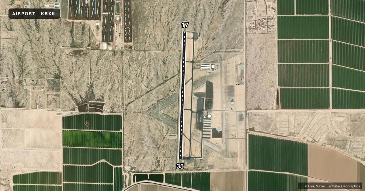
Airport sketch
Runways drawn to scale from FAA survey coordinates, rendered over satellite imagery. Not for navigation.
Approaches & charts
Services on the field
Fuel grades, oxygen, maintenance, ramp storage and lighting — as declared to the FAA by the airport operator.
Fuel & services
- Fuel
- 100LLA1
- Airframe repair
- Major
- Power plant repair
- Major
- Other services
- GLD,PAJA
Ramp & ground
- Transient storage
- Tie-down
- Landing fee
- No fee published
- Customs
- Not available
- Lighting schedule
- SEE RMK
- Beacon schedule
- SS-SR
- Beacon
- White / Green (civil land)(WG)
- Wind indicator
- Lighted
- Segmented circle
- Yes
Fuel & FBOs
Cheapest 100LL and Jet A on the field and nearby. Always confirm with the FBO before taxi.
Airport notes
Surface conditions, obstructions, local procedures, lighting outages and other notes published with each FAA cycle.
General notes
- LOW LEVEL JET TFC, PAJA & WILDLIFE ON & INVOF ARPT.
- FOR CD CTC LUKE APCH AT 623-856-7361. IF UNABLE, CTC PHOENIX APCH AT 602-306-2565.
- PAJA DROP ZONE E OF RWY; APCH FM W; OVERFLIGHT OF ARPT OR E OF RWY NA.
- TSNT PRKG N OF TWY C. TENANT PRKG S OF TWY C.
Lighting notes
- ACTVT MIRL RWY 17/35 - CTAF. PAPI RWY 17 & 35 OPR CONSLY.
Fuel notes
- 100LLFUEL SVC AVBL H24 VIA CREDIT CARD.
- A1PPR - 623-295-9776.
Runway surface & condition
- 17/35RWY 17 CALM WIND RWY.
VFR map & nearby airports
VFR sectional. Tap any ICAO chip to open that airport.
Key facts · KBXK
Answer card- ICAO
- KBXK
- Name
- BUCKEYE MUNI
- Location
- BUCKEYE, ARIZONA
- Elevation
- 1,033 ft MSL
- Traffic pattern altitude
- 2,009 ft MSL (976 AGL)
- Control tower
- Non-towered (use CTAF)
- Total runways
- 1
- Longest runway
- 17/35 · 5,500 ft
- Published ILS approaches
- 0
- Published frequencies
- 10
- Magnetic variation
- 13°
- Current flight rules
- VFR
- Current wind
- 280° at 4 kt
- Favored runway now
- RWY 35
Buckeye Muni sits in Buckeye, Arizona. The field elevation is 1,033 ft MSL. It has one runway, 17/35, which is 5,500 ft of asphalt. There is no control tower. Pattern altitude is 976 ft AGL, which is 2,009 ft MSL. No ILS approaches are published here.
The on-field FBO is Buckeye Municipal Airport. It carries AVGAS 100LL. Published remarks say 100LL is available 24 hours a day by credit card. Jet A requires prior permission, so call ahead if you need turbine fuel. Runway 17 is the calm wind runway. The runway lights are activated by CTAF. The PAPI on 17 and 35 operates continuously.
This is a field where the local notes matter. Low level jet traffic, PAJA and wildlife are reported in the area. The PAJA drop zone is east of the runway. Approach from the west. Overflight of the airport or east of the runway is not authorized. For clearances, contact Luke Approach first. If needed, Phoenix Approach is the backup. Pilots should also check the current FAA Chart Supplement for any updated operating notes before flying in.