METAR & TAF E25
E25 does not publish a METAR.
Showing the nearest reporting station: KBXK (BUCKEYE MUNI) · 33.4 NM away. Conditions at E25 may differ.
METAR · KBXK
Observed 11:35Z
KBXK 271135Z AUTO 28004KT 10SM CLR 32/17 A2986 RMK AO2
- Wind
- 280° @ 4 kt
- Visibility
- 10 SM
- Temp / Dew
- 32°C / 17°C
- Altimeter
- 29.86 inHg
- Clouds
- CLR
- Density alt
- 5,064 ft
- Ceiling
- Unlimited
- Rules
- VFR
Airport info & contacts
Manager on record, flight service, ARTCC, attendance schedule and pattern altitude — published by the FAA and refreshed every 28 days.
Location
- From city
- 3 NM W
- VFR sectional
- PHOENIX
- ARTCC
- ZAB · ALBUQUERQUE
- NOTAM facility
- PRC (NOTAM-D)
Airport manager
- Name
- CASON CHAMBERS
- Phone
- 928-668-0564
- Address
- 155 NORTH TEGNER ST SUITE A, WICKENBURG AZ 85390
Flight service · Hours
- FSS PRC
- PRESCOTT1-800-WX-BRIEF
- Attendance
- TUE-SAT · 0700-1600
Frequencies
Tap any row to copy the frequency to your clipboard.
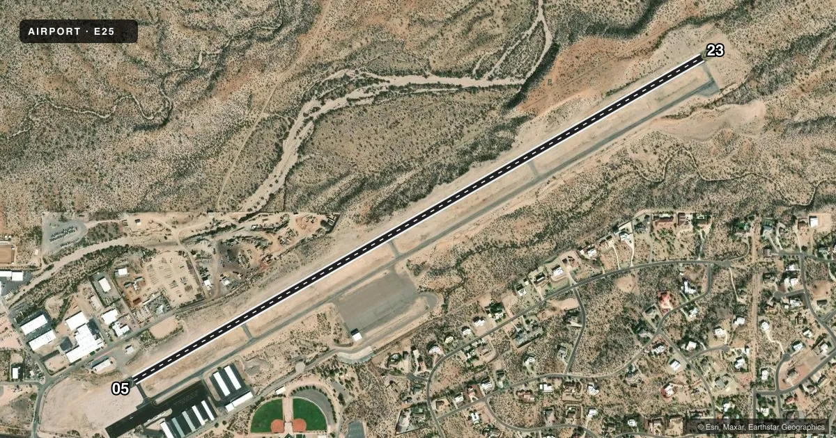
Runways & pattern
Full pagePattern entry · RWY 23
RIGHT TRAFFICRunway end performance
| End | TORA | TODA | ASDA | LDA | VGSI | Approach lights | Obstruction |
|---|---|---|---|---|---|---|---|
| 05 | — | — | — | — | PAPI 4-box left(3°) | — | 3', gnd, 201' from thr, 100' R of cntrln, slope 0 |
| 23 | — | — | — | — | PAPI 4-box left(3°) | — | — |
Declared distances in feet. TORA = takeoff run available, TODA = takeoff distance, ASDA = accelerate-stop, LDA = landing distance.
Airport sketch
Runways drawn to scale from FAA survey coordinates, rendered over satellite imagery. Not for navigation.
Approaches & charts
Services on the field
Fuel grades, oxygen, maintenance, ramp storage and lighting — as declared to the FAA by the airport operator.
Fuel & services
- Fuel
- 100LLA1+
- Airframe repair
- Minor
- Power plant repair
- Minor
Ramp & ground
- Transient storage
- Tie-down
- Landing fee
- No fee published
- Customs
- Not available
- Lighting schedule
- SEE RMK
- Beacon schedule
- SS-SR
- Beacon
- White / Green (civil land)(WG)
- Wind indicator
- Lighted
- Segmented circle
- Yes
Fuel & FBOs
Cheapest 100LL and Jet A on the field and nearby. Always confirm with the FBO before taxi.
Airport notes
Surface conditions, obstructions, local procedures, lighting outages and other notes published with each FAA cycle.
General notes
- WILDLIFE ON OR INVOF ARPT.
- FOR CD CTC LUKE APCH AT 623-856-7361. IF UNA CTC ALBUQUERQUE ARTCC AT 505-856-4861.
- SELF SVC FUEL H24 WITH CREDIT CARD. JET A CALL OUT FEE AFT 1600 & SUN & MON.
Lighting notes
- ACTVT REIL RWY 05 & 23; PAPI RWY 05 & 23; MIRL RWY 05/23; TWY LGTS - CTAF. DAWN-DUSK: PAPI RWY 05 & 23 OPR CONSLY.
Approach & departure obstructions
- 051-3 FT BRUSH 50-190 FT FM THR 40 FT L & R OF CNTRLN.
- 231-3 FT BRUSH 0-200 FT FM THR 50-70 FT R OF CNTRLN.
- 05150 FT BLAST PAD.
- 23150 FT BLAST PAD.
Other notes
- 1AFT HR - 928-232-0397.
VFR map & nearby airports
VFR sectional. Tap any ICAO chip to open that airport.
Key facts · E25
Answer card- ICAO
- E25
- Name
- WICKENBURG MUNI
- Location
- WICKENBURG, ARIZONA
- Elevation
- 2,378.6 ft MSL
- Traffic pattern altitude
- 3,378.6 ft MSL (1,000 AGL)
- Control tower
- Non-towered (use CTAF)
- Total runways
- 1
- Longest runway
- 05/23 · 6,101 ft
- Published ILS approaches
- 0
- Published frequencies
- 2
- Magnetic variation
- 13°
- Current flight rules
- VFR
- Current wind
- 280° at 4 kt
- Favored runway now
- RWY 23
Wickenburg Muni (E25) sits in Wickenburg, Arizona at 2,378.6 ft MSL. The field has one runway. Runway 05/23 is 6,101 ft long, which gives you room for most light GA traffic. There is no control tower, so plan for CTAF and UNICOM self-announce work. CTAF and UNICOM are both 123.0. No ILS approaches are published here. Check the current charting for the approach picture before you go.
Pattern altitude is not published. Use 1,000 ft AGL for light piston operations unless the current FAA Chart Supplement says otherwise. The on-field FBO is Wickenburg Municipal Airport. It carries 100LL and Jet A Prist. Self-serve fuel is available 24 hours a day with a credit card. Jet A needs a call-out fee after 1600 and on Sunday and Monday. Published remarks also note wildlife on or near the airport.
Runway lighting is installed on 05/23. REILs and PAPI are on both ends. Taxiway lights are controlled by CTAF. Runway 05 has a 150-foot blast pad. Runway 23 has a 150-foot blast pad. There is brush near both thresholds, so give the runway ends a close look on final. For clearance delivery, contact Luke Approach. If that does not work, use Albuquerque ARTCC. This is a non-towered field in a high-desert setting. Density altitude, wildlife and runway-end obstructions are the main things a first-time pilot should brief.