METAR & TAF E51
E51 does not publish a METAR.
Showing the nearest reporting station: KPRC (PRESCOTT RGNL/ERNEST A LOVE FLD) · 37.4 NM away. Conditions at E51 may differ.
METAR · KPRC
Observed 02:00Z
KPRC 250200Z 28007KT 10SM FEW001 33/11 A3013 RMK AO2 T03330106
- Wind
- 280° @ 7 kt
- Visibility
- 10 SM
- Temp / Dew
- 33°C / 11°C
- Altimeter
- 30.13 inHg
- Clouds
- FEW
- Density alt
- 7,102 ft
- Ceiling
- Unlimited
- Rules
- VFR
Airport info & contacts
Manager on record, flight service, ARTCC, attendance schedule and pattern altitude — published by the FAA and refreshed every 28 days.
Location
- From city
- 2 NM NE
- VFR sectional
- PHOENIX
- ARTCC
- ZAB · ALBUQUERQUE
- NOTAM facility
- PRC (NOTAM-D)
Airport manager
- Name
- MIKE ECKEL
- Phone
- 928-771-3183
- Address
- 1100 COMMERCE DRIVE, PRESCOTT AZ 86305
Flight service · Hours
- FSS PRC
- PRESCOTT1-800-WX-BRIEF
- Attendance
- Unattended
Frequencies
Tap any row to copy the frequency to your clipboard.
Runways & pattern
Full pagePattern entry · RWY 23
LEFT TRAFFICRunway end performance
| End | TORA | TODA | ASDA | LDA | VGSI | Approach lights | Obstruction |
|---|---|---|---|---|---|---|---|
| 23 | — | — | — | — | — | — | 2', fence, 240' from thr, 125' R of cntrln, slope 20 |
Declared distances in feet. TORA = takeoff run available, TODA = takeoff distance, ASDA = accelerate-stop, LDA = landing distance.
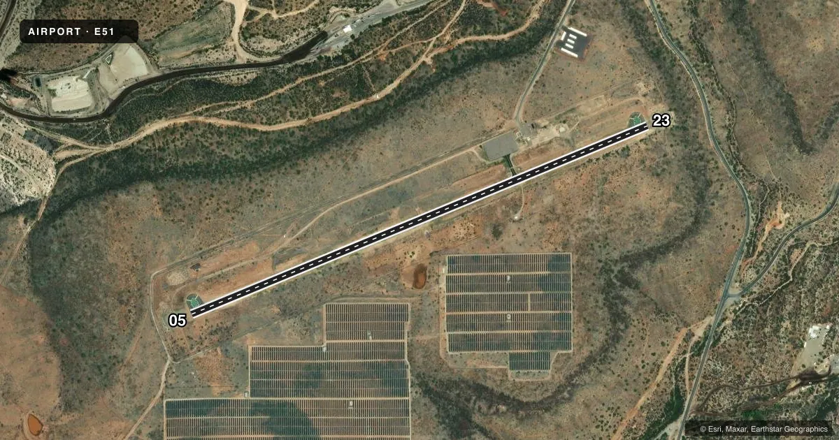
Airport sketch
Runways drawn to scale from FAA survey coordinates, rendered over satellite imagery. Not for navigation.
Approaches & charts
Services on the field
Fuel grades, oxygen, maintenance, ramp storage and lighting — as declared to the FAA by the airport operator.
Fuel & services
- Fuel
- Not available
Ramp & ground
- Transient storage
- Tie-down
- Landing fee
- No fee published
- Customs
- Not available
- Wind indicator
- Yes
- Segmented circle
- No
Fuel & FBOs
Cheapest 100LL and Jet A on the field and nearby. Always confirm with the FBO before taxi.
Airport notes
Surface conditions, obstructions, local procedures, lighting outages and other notes published with each FAA cycle.
General notes
- UNUSBL AIR CURRENT INVOF APRT; SPCLY RWY 23 APCH END.
- MTS E, NE, NW ABV PART 77 CONICAL SFDC.
- LCTD ON MESA.
Approach & departure obstructions
- 23+2-4 FT BRUSH 90-200 FT FM THR 60-125 FT R OF CNTRLN. +4-8 FT BRUSH 0-200 FT FM THR 60-125 FT L OF CNTRLN.
Other notes
- MANAGEREMERG - SHERIFF 928-771-3260.
VFR map & nearby airports
VFR sectional. Tap any ICAO chip to open that airport.
Key facts · E51
Answer card- ICAO
- E51
- Name
- BAGDAD
- Location
- BAGDAD, ARIZONA
- Elevation
- 4,195.7 ft MSL
- Traffic pattern altitude
- 5,195.7 ft MSL (1,000 AGL)
- Control tower
- Non-towered (use CTAF)
- Total runways
- 1
- Longest runway
- 05/23 · 4,552 ft
- Published ILS approaches
- 0
- Published frequencies
- 1
- Magnetic variation
- 13°
- Current flight rules
- VFR
- Current wind
- 280° at 7 kt
- Favored runway now
- RWY 23
Bagdad Airport sits in Bagdad, Arizona. The field elevation is 4,195.7 ft MSL. It has one runway, 05/23, which is 4,552 ft of asphalt. There is no control tower. CTAF is 122.9. No ILS approaches are published here.
Pattern altitude is not published. Use the standard 1,000 ft AGL pattern for light piston operations unless local guidance says otherwise. The airport sits on a mesa. Mountains are east, northeast and northwest above the Part 77 conical surface. That matters for climb planning. It also matters for staying alert on departure and arrival.
Published remarks also call out brush near the runway 23 end. The brush sits close to the threshold on both sides of the centerline. The field also has unusable air currents in the area, especially near the runway 23 approach end. Expect that to affect your final and your go-around planning. No on-field FBOs are listed. If you need fuel or ground support, contact the airport operator or the field directly before arrival. The published remarks also list a sheriff emergency contact at 928-771-3260.