METAR & TAF P52
Current METAR
Observed 16:35Z
KP52 261635Z AUTO 00000KT 10SM CLR 31/15 A3011 RMK AO2
- Wind
- 000° @ 0 kt
- Visibility
- 10 SM
- Temp / Dew
- 31°C / 15°C
- Altimeter
- 30.11 inHg
- Clouds
- CLR
- Density alt
- 6,099 ft
- Ceiling
- Unlimited
- Rules
- VFR
Airport info & contacts
Manager on record, flight service, ARTCC, attendance schedule and pattern altitude — published by the FAA and refreshed every 28 days.
Location
- From city
- 1 NM SW
- VFR sectional
- PHOENIX
- Pattern altitude
- 800 ft AGL · 4,360 ft MSL
- ARTCC
- ZAB · ALBUQUERQUE
- NOTAM facility
- PRC (NOTAM-D)
Airport manager
- Name
- ROD PROPST
- Phone
- 928-340-2722
- Address
- 1001 W MINGUS AVE, COTTONWOOD MUNICIPAL AIRPORT, COTTONWOOD AZ 86326
Flight service · Hours
- FSS PRC
- PRESCOTT1-800-WX-BRIEF
- Attendance
- MON-FRI · 0800-1700
Frequencies
Tap any row to copy the frequency to your clipboard.
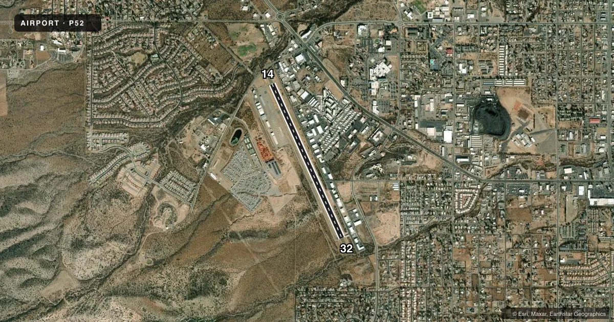
Runways & pattern
Full pagePattern entry · RWY 14
LEFT TRAFFICRunway end performance
| End | TORA | TODA | ASDA | LDA | VGSI | Approach lights | Obstruction |
|---|---|---|---|---|---|---|---|
| 14 | — | — | — | — | PAPI 2-box left(3°) | — | — |
| 32 | — | — | — | — | PAPI 2-box left(3.6°) | — | 8', brush, 201' from thr, 144' R of cntrln, slope 0 |
Declared distances in feet. TORA = takeoff run available, TODA = takeoff distance, ASDA = accelerate-stop, LDA = landing distance.
Airport sketch
Runways drawn to scale from FAA survey coordinates, rendered over satellite imagery. Not for navigation.
Approaches & charts
Services on the field
Fuel grades, oxygen, maintenance, ramp storage and lighting — as declared to the FAA by the airport operator.
Fuel & services
- Fuel
- 100LL
- Other services
- AMB
Ramp & ground
- Transient storage
- Tie-down
- Landing fee
- No fee published
- Customs
- Not available
- Lighting schedule
- SEE RMK
- Beacon schedule
- SS-SR
- Beacon
- White / Green (civil land)(WG)
- Wind indicator
- Lighted
- Segmented circle
- Yes
Fuel & FBOs
Cheapest 100LL and Jet A on the field and nearby. Always confirm with the FBO before taxi.
Airport notes
Surface conditions, obstructions, local procedures, lighting outages and other notes published with each FAA cycle.
General notes
- GLIDERS & WILDLIFE INVOF ARPT.
- FOR CD CTC PHOENIX APCH AT 602-306-2565.
- TGL OPS NA 1800-0800 WKDAY & 1800-0900 WKEND & HOL. MORE THAN THREE ACFT CONDUCTING TGL OPS IN PAT NA.
Lighting notes
- ACTVT REIL RWY 14 & 32; PAPI RWY 14 & 32; MIRL RWY 14/32 - CTAF.
Fuel notes
- 100LLH24 WITH CREDIT CARD.
Runway surface & condition
- 14/32RWY 32 CALM WIND RWY.
- 14/32300 FT PAVED STWY BOTH ENDS.
Approach & departure obstructions
- 3212 FT BRUSH 50-200 FT FM THR 120-175 FT R OF CNTRLN; 15 FT BRUSH 0-200 FT FM THR 60-250 FT L OF CNTRLN; 4 FT BERM 30-200 FT FM THR 125-250 FT L OF CNTRLN.
Other notes
- TPA: 800 FT AGL SINGLE ENG.
- CALL AHEAD FOR AVBL.
- MANAGEREMERG - POLICE 928-634-4246.
VFR map & nearby airports
VFR sectional. Tap any ICAO chip to open that airport.
Key facts · P52
Answer card- ICAO
- P52
- Name
- COTTONWOOD
- Location
- COTTONWOOD, ARIZONA
- Elevation
- 3,560.3 ft MSL
- Traffic pattern altitude
- 4,360.3 ft MSL (800 AGL)
- Control tower
- Non-towered (use CTAF)
- Total runways
- 1
- Longest runway
- 14/32 · 4,250 ft
- Published ILS approaches
- 0
- Published frequencies
- 4
- Magnetic variation
- 11°
- Current flight rules
- VFR
- Current wind
- 000° at 0 kt
- Favored runway now
- –
Cottonwood Airport (P52) sits in Cottonwood, Arizona at 3,560.3 ft MSL. It has one runway, 14/32, which is 4,250 ft long. There is no control tower. CTAF and UNICOM are both 122.7. Phoenix Approach handles clearance delivery and approach or departure services on 126.375 and 236.775. No ILS approaches are published here.
The published pattern altitude is not standard in the FAA data for this field. Use the current Chart Supplement before you go. The remarks do publish helicopter, single-engine, multi-engine and turbine pattern altitudes. For single-engine aircraft, the published pattern altitude is 4,350 ft MSL or 800 ft AGL. Runway 32 is the calm wind runway. Rwy 14 and 32 have REILs, PAPI and medium intensity runway lights controlled by CTAF. There is also a 300 ft paved stopway at both ends.
Cottonwood Airport has one on-field FBO, Cottonwood Airport. It carries 100LL. 100LL is available 24 hours with credit card. The remarks also note gliders and wildlife in the vicinity. There is brush and a small berm near the 32 threshold. Use very low airspeeds until 1,000 ft. Repetitive flight training is restricted during late evening and overnight periods on weekdays. It is also restricted on weekends and holidays. Call ahead for availability before you launch.