METAR & TAF KSEZ
Current METAR
Observed 12:55Z
KSEZ 271255Z AUTO 04008KT 10SM CLR 23/14 A3017 RMK AO2
- Wind
- 040° @ 8 kt
- Visibility
- 10 SM
- Temp / Dew
- 23°C / 14°C
- Altimeter
- 30.17 inHg
- Clouds
- CLR
- Density alt
- 6,640 ft
- Ceiling
- Unlimited
- Rules
- VFR
Airport info & contacts
Manager on record, flight service, ARTCC, attendance schedule and pattern altitude — published by the FAA and refreshed every 28 days.
Location
- From city
- 2 NM SW
- VFR sectional
- PHOENIX
- ARTCC
- ZAB · ALBUQUERQUE
- NOTAM facility
- SEZ (NOTAM-D)
Airport manager
- Name
- EDWARD A. ROSE
- Phone
- 928-282-4487
- Address
- 235 AIR TERMINAL DRIVE, SEDONA AZ 86336
Flight service · Hours
- FSS PRC
- PRESCOTT1-800-WX-BRIEF
- Attendance
- MAY-SEP · 0700-1800
- OCT-APR · 0700-2000
Frequencies
Tap any row to copy the frequency to your clipboard.
Runways & pattern
Full pagePattern entry · RWY 03
LEFT TRAFFICRunway end performance
| End | TORA | TODA | ASDA | LDA | VGSI | Approach lights | Obstruction |
|---|---|---|---|---|---|---|---|
| 03 | — | — | — | — | PAPI 4-box left(3°) | — | — |
| 21 | — | — | — | — | PAPI 4-box left(3.5°) | — | 8', fence, 201' from thr, 70' R of cntrln, slope 0 |
Declared distances in feet. TORA = takeoff run available, TODA = takeoff distance, ASDA = accelerate-stop, LDA = landing distance.
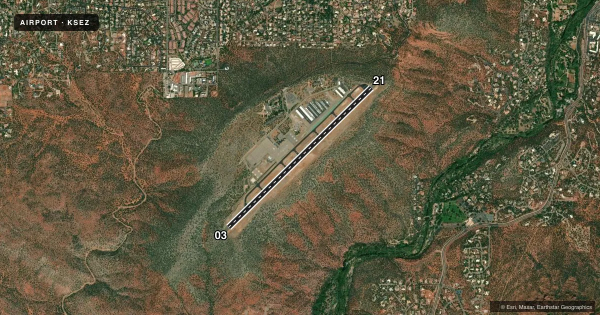
Airport sketch
Runways drawn to scale from FAA survey coordinates, rendered over satellite imagery. Not for navigation.
Approaches & charts
Services on the field
Fuel grades, oxygen, maintenance, ramp storage and lighting — as declared to the FAA by the airport operator.
Fuel & services
- Fuel
- 100LLAA+
- Airframe repair
- Minor
- Power plant repair
- Minor
- Other services
- CHTR,INSTR
Ramp & ground
- Transient storage
- Tie-down
- Landing fee
- Yes
- Customs
- Not available
- Lighting schedule
- SEE RMK
- Beacon schedule
- SS-SR
- Beacon
- White / Green (civil land)(WG)
- Wind indicator
- Lighted
- Segmented circle
- Yes
Fuel & FBOs
Cheapest 100LL and Jet A on the field and nearby. Always confirm with the FBO before taxi.
Airport notes
Surface conditions, obstructions, local procedures, lighting outages and other notes published with each FAA cycle.
General notes
- ARPT ON 500 FT MESA; WS, TURB, UP & DOWN DRAFTS NEAR MESA EDGE.
- OVNGT TSNT FEE.
- HOP FM HELI S & W OF RWY; HOP RSTRD TO HELI ADJ TO TWY INTXN A7 SW MAIN TRML BLDG.
- NOISE ABATEMENT PROC IN EFCT; SCENIC FLT BLW 6500 FT MSL NA.
- BIRDS & WILDLIFE ON & INVOF ARPT.
- FOR CD CTC PHOENIX APCH AT 602-306-2565.
Lighting notes
- ACTVT REIL RWY 03 & 21; PAPI RWY 03 & 21; MIRL RWY 03/21 - CTAF.
Fuel notes
- 100LLAFT HR CALL OUT FEE.
- A10 PCT SHF.
Runway surface & condition
- 03/21RWY 03 CALM WIND RWY FOR LNDG; RWY 21 FOR TKOFF.
Approach & departure obstructions
- 031 FT FENCE POST 125 FT FM THR 75 FT L OF CNTRLN LGTD SS-SR.
- 218 FT FENCE 100-200 FT FM THR 90-125 FT L OF CNTRLN LGTD SS-SR.
- 21PAPI UNUSBL BYD 2.0 NM.
Other notes
- TPA FOR PROPELLER ACFT 1173 AGL, JET ACFT 2173 AGL.
- MANAGEREMERG 928-300-3304.
VFR map & nearby airports
VFR sectional. Tap any ICAO chip to open that airport.
Key facts · KSEZ
Answer card- ICAO
- KSEZ
- Name
- SEDONA
- Location
- SEDONA, ARIZONA
- Elevation
- 4,830.5 ft MSL
- Traffic pattern altitude
- 5,830.5 ft MSL (1,000 AGL)
- Control tower
- Non-towered (use CTAF)
- Total runways
- 1
- Longest runway
- 03/21 · 5,132 ft
- Published ILS approaches
- 0
- Published frequencies
- 4
- Magnetic variation
- 13°
- Current flight rules
- VFR
- Current wind
- 040° at 8 kt
- Favored runway now
- RWY 03
Sedona Airport (KSEZ) sits in Sedona, Arizona. The field elevation is 4,830.5 ft MSL. It has one runway, 03/21, which is 5,132 ft long. There is no control tower. Approach and departure service is handled by Phoenix Approach on the published frequencies. No ILS approaches are published.
The traffic pattern altitude is 1,173 ft AGL for propeller aircraft. Jet pattern altitude is 2,173 ft AGL. Red Rock Aviation is on the field. It carries 100LL, Jet A and Jet A Prist. Call the FBO directly at (928) 282-1046 for current service details.
This is a mesa airport. Expect wind shear, turbulence, updrafts and downdrafts near the mesa edge. The Chart Supplement also notes noise abatement procedures. Scenic flight below 6,500 ft MSL is not authorized. Runway 03 is the calm wind landing runway. Runway 21 is for takeoff. There is also a lighted fence post near the threshold of Runway 03. Birds and wildlife are reported on and near the airport. If you are planning a first trip here, review the current Chart Supplement and brief the mesa environment before arrival.